
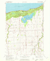
1970 Map of Port Austin West
USGS Topo · Published 1973About this map
The northern tip of Michigan's Thumb is captured here in 1970, where the waters of Lake Huron meet Saginaw Bay. This coastal landscape is defined by its recreation and Cold War infrastructure, notably the Port Austin Air Force Station situated near the eastern edge. Along the shoreline, the treacherous nature of the lake bottom is revealed by the extensive Flat Rock Point Reef and Hat Point Reef, which extend significantly from the coast. The map provides a detailed view of the Port Crescent State Park and the historic Port Crescent area, where the Pinnebog R winds toward the bay. Interior roads like Knoblock Road and Ahearn Road service the farmland behind the coastal bluffs, while local history is preserved at the Port Crescent Cem.
Find a feature on this map
29 named features on this map. Tap any name to fly to it.
Don’t see what you’re looking for? This feature index may not catch every label — zoom into the map to look around manually.
Map Details
Editions of this 1970 Port Austin West Map
This is the sole edition of this map. No revisions or reprints were ever made.
Other maps of this area

1954 · Flint
USGS Topo · 1:250,000

1954 · Tawas City
USGS Topo · 1:250,000

1958 · Flint
USGS Topo · 1:250,000

1958 · Tawas City
USGS Topo · 1:250,000
1970 · Rush Lake
USGS Topo · 1:24,000

1970 · Port Austin East
USGS Topo · 1:24,000

1970 · Kinde East
USGS Topo · 1:24,000

1970 · Kinde West
USGS Topo · 1:24,000

1984 · Harbor Beach
USGS Topo · 1:100,000
1984 · Pointe Aux Barques
USGS Topo · 1:100,000