Old Maps of Kiernan, Mansfield Township for Hiking & Exploration
Hike through history with 14 historic maps of Kiernan. Explore old trails, ghost towns, and forgotten backroads — perfect for outdoor adventurers and local explorers.
- Rediscover forgotten places: Map out old mining camps, roads, and footpaths that no longer exist on modern maps.
- Layer with modern tools: Combine with LiDAR or satellite views to plan hikes through historical terrain.
- Made for exploration: Popular among hikers, overlanders, and local history lovers.
Use these maps to find adventure and explore the hidden past of Kiernan.
Kiernan, Mansfield Township maps
(14)- 1899 Map of Sagola
 1899 Sagola1899 Print · USGSIron and Dickinson counties were defined by the expansion of the rail-and-river economy in the late nineteenth century. Genealogists and historians can trace the early layouts of Channing, Sagola, and Mansfield alongside the winding Michigamme River.3 unique versions available
 - 1947 Map of Kiernan
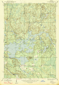 1947 Kiernan1947 Print · USGSIron County’s timber and water landscapes are captured here shortly after the war, showing the newly formed Michigamme Reservoir. Genealogists and historians can trace the rail corridor of the Chicago Milwaukee St Paul and Pacific and the small settlement at Kiernan.2 unique versions available
 - 1956 Map of Kiernan, 1957 Print
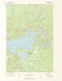 1956 Kiernan1957 Print · USGSThe Iron Range State Forest area in the mid-1950s is defined by the massive Michigamme Reservoir and its surrounding timberlands. Researchers can trace the path of the Chicago Milwaukee St Paul and Pacific railroad through Kiernan and locate early sites like McMillan Camp and Way Dam.4 unique versions available
 - 1956 Map of Sagola, 1957 Print
 1956 Sagola1957 Print · USGSUpper Peninsula timber and rail history converge in the mid-fifties at the junction of the Chicago and North Western Railway. Trace the footprints of logging and mining settlements at Channing, Mansfield Location, and the McMillan Camp.
 - 1958 Map of Iron River, 1968 Print
 1958 Iron River1968 Print · USGSThe Upper Peninsula in the late fifties is captured here as a landscape of timber, iron, and rail. Genealogists and historians can trace rail stops like Mass Station or explore the coastlines of Lake Gogebic and Keweenaw Bay.3 unique versions available
 - 1960 Map of Iron River
 1960 Iron River1960 Print · USGSThe Upper Peninsula’s western reaches are shown in the late fifties, featuring the industrial infrastructure of the Copper Country and the vast Ottawa National Forest. Researchers can trace the rail lines of the Milwaukee Road through settlements like Bruce Crossing and the White Pine Mine.
 - 1961 Map of Iron River
 1961 Iron River1961 Print · USGSThe Upper Peninsula and northern Wisconsin are shown here in the early 1960s, a landscape defined by the iron range and vast timberlands. Researchers can trace the legacy of mining and rail transport through Caspian, the Lac Du Flambeau Indian Reservation, and the Milwaukee Road.
 - 1967 Map of Iron River, 1968 Print
 1967 Iron River1968 Print · USGSThe Upper Peninsula and northern Wisconsin borderlands are shown here in the late sixties, a landscape of deep woods and iron-country rail lines. Genealogists and historians can trace the lakeside settlements of L'Anse and Ontonagon or follow the Soo Line through towns like Michigamme and Nestoria.
 - 1989 Map of Iron River, 1990 Print
 1989 Iron River1990 Print · USGSUpper Peninsula mining and timber lands are documented here in the late 1980s, showcasing the region's industrial and natural interface. Researchers can trace the iron heritage through the Monongahela Mine and local junctions like Kelso Junction and Amasa.
 - 2011 Map of Kiernan, 2011 Print
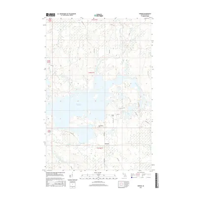
 2011 Kiernan2011 Print · USGSCovers Kiernan, including Mansfield Township, Crystal Falls Township, and other nearby areas
 - 2014 Map of Kiernan, 2014 Print
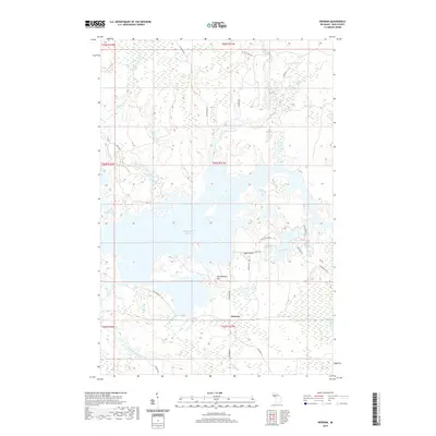
 2014 Kiernan2014 Print · USGSCovers Kiernan, including Mansfield Township, Crystal Falls Township, and other nearby areas
 - 2017 Map of Kiernan, 2017 Print
 2017 Kiernan2017 Print · USGSCovers Kiernan, including Mansfield Township, Crystal Falls Township, and other nearby areas
 - 2019 Map of Kiernan, 2019 Print
 2019 Kiernan2019 Print · USGSCovers Kiernan, including Mansfield Township, Crystal Falls Township, and other nearby areas
 - 2023 Map of Kiernan, 2023 Print
 2023 Kiernan2023 Print · USGSIron County's northern forests and waterways appear in contemporary detail, centered on the small settlement of Kiernan and the expansive Michigamme Reservoir. Researchers can trace the winding paths of the Fence River, locate Huber Airport, and find family-named routes like Phelan Rd.
End of results
Showing maps 1-14 of 14
Top cities near Kiernan
- Crystal Falls historical maps
- Sagola historical maps
- Mastodon historical maps
- Florence historical maps
- Mansfield historical maps
- Alpha historical maps
Frequently asked questions
- What are the different types of historical maps available for Kiernan?
- What is the oldest map of Kiernan?
- Where can I purchase historical maps of Kiernan for my home or office?
- Where can I download high-res historical maps of Kiernan?
- Are there historical topographic maps available for Kiernan?
- Is there historical aerial imagery available for Kiernan?
- Where are historical maps of Kiernan sourced from?