2020s Maps of Stambaugh Township, Michigan
Explore 12 historic maps of Stambaugh Township from the 2020s. These maps offer a rare glimpse into what life looked like during the 2020s — showing old roads, neighborhoods, homes, and landmarks that have changed or disappeared over time.
Whether you're researching your family's past, planning a metal detecting trip, or studying how Stambaugh Township's landscape evolved across the 2020s, these high-resolution maps are a powerful tool for exploring the history of this region.
- Focus on a specific era: All maps on this page are from the 2020s, giving you a focused view of this time period.
- See what’s changed: Compare century-old streets, trails, and buildings to today's modern landscape using overlays and satellite layers.
- Research with precision: Use these maps for genealogy, historical research, land use analysis, or educational projects.
- View, download, or print: Maps are fully viewable online in high resolution, and can be downloaded or printed for your own records.
Start exploring Stambaugh Township's history through authentic maps from the 2020s. This is your window into the past.
Stambaugh Township, MI maps
(12)- 2022 Map of Long Lake NE, 2022 Print
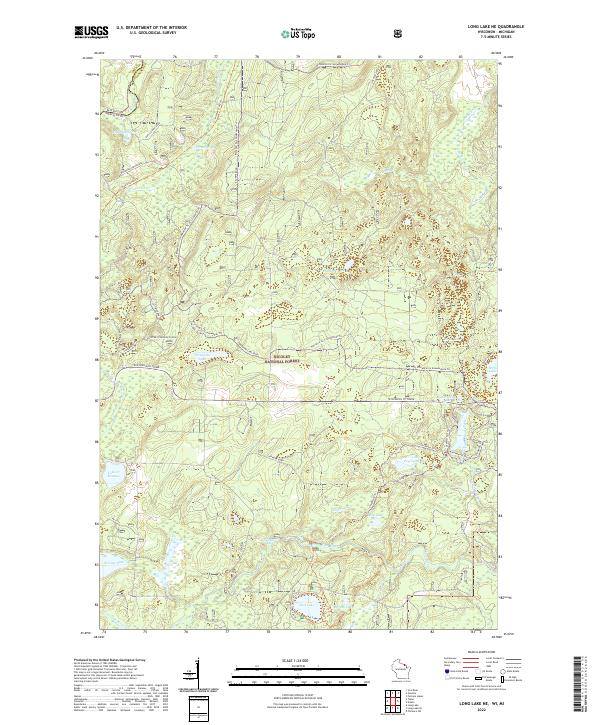 2022 Long Lake NE2022 Print · USGSThe Wisconsin-Michigan borderlands come into focus in this recent survey of the Florence County wilderness. Genealogists and outdoor historians can trace the legacy of Northwoods recreation and industry through landmarks like Chipmunk Rapids, the Nicolet State Trl, and Lake of Dreams.
 - 2022 Map of Tipler, 2022 Print
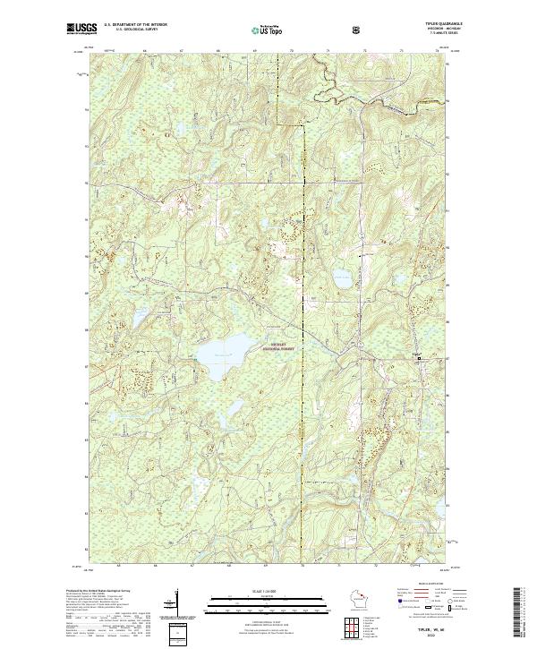 2022 Tipler2022 Print · USGSThe Northwoods of Wisconsin and Michigan's Upper Peninsula meet in this 2022 study of the Nicolet National Forest. Genealogists and historians can trace the community of Tipler, identifying locations like Tipler Cem and Martin Cem.
 - 2023 Map of Gaastra, 2023 Print
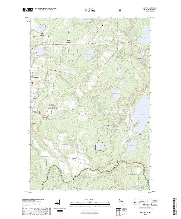 2023 Gaastra2023 Print · USGSUpper Peninsula mining and forest life converge in this study of the Iron River area in the early twenty-first century. Researchers can trace the layout of Gaastra, Stambaugh, and Palatka or locate local landmarks like the Bates Cem and Indian Burial Ground.
 - 2023 Map of Hagerman Lake, 2023 Print
 2023 Hagerman Lake2023 Print · USGSThe borderlands of Iron County and Wisconsin come alive in this recent survey of the deep northwoods. Researchers can trace the winding Brule River through Nelma or locate specific lakeside properties along Hagerman Lake and Brule Lake.
 - 2023 Map of Naults, 2023 Print
 2023 Naults2023 Print · USGSThe Michigan-Wisconsin borderlands are shown here in the 2020s, dominated by the timber and water of the Whisker Lake Wilderness. You can trace old routes near the settlement of Naults or locate remote water bodies like Camp Thirteen Lake and Boot Lake.
 - 2023 Map of Iron River, 2023 Print
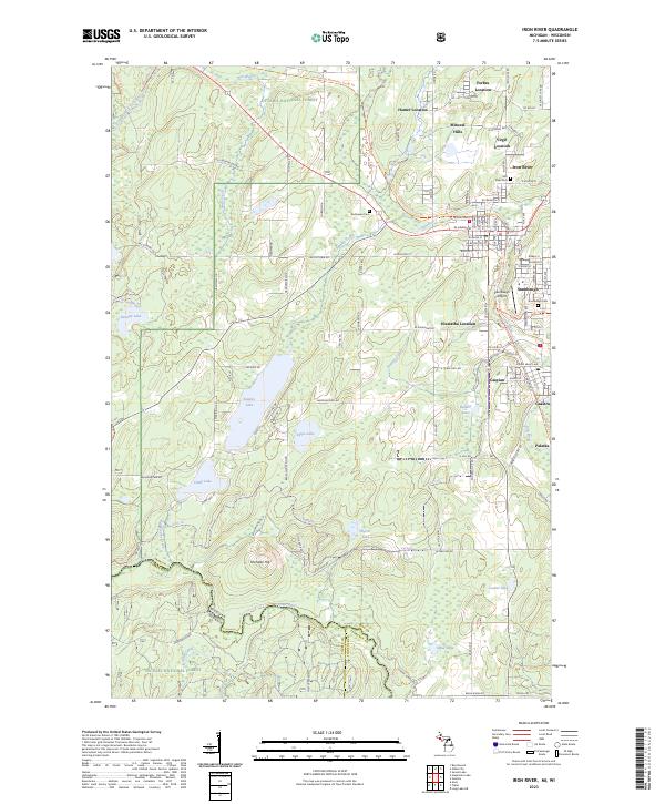 2023 Iron River2023 Print · USGSIron County's mining heritage is preserved in this detailed study of the Upper Peninsula at the border of Wisconsin. Researchers can trace the layout of legacy communities like Mineral Hills and Gaastra, or locate family sites at River Cem and Stambaugh Cem.
 - 2023 Map of Smoky Lake, 2023 Print
 2023 Smoky Lake2023 Print · USGSThe Michigan and Wisconsin state line bisects this lake-strewn forest landscape during the early 2020s. Genealogists and local historians can trace old access routes like Mail Route Road or locate quiet landmarks like Elvoy Springs and Ishkote Lake.
 - 2023 Map of Winslow Lake, 2023 Print
 2023 Winslow Lake2023 Print · USGSUpper Peninsula timberlands and river corridors are charted here in the twenty-first century, centered on the Paint Wild and Scenic River. Researchers can trace remote waterways and forest access points like Big Spring Hole, Winslow Lake, and Gibbs City Rd.
 - 2023 Map of Lake Mitigwaki, 2023 Print
 2023 Lake Mitigwaki2023 Print · USGSThe northern Michigan wilderness at the junction of Iron, Ontonagon, and Gogebic counties remains a landscape defined by water and timber. Foresters and hikers can trace the remote access roads and primitive trails leading to secluded waters like Lake Mitigwaki, Whisper Lake, and Paint Lake.
 - 2023 Map of Golden Lake, 2023 Print
 2023 Golden Lake2023 Print · USGSIron County's timbered heartland is documented here in the early twenty-first century. Researchers can trace the water network from James Lake to the South Branch Paint River and locate the settlement of Elmwood.
 - 2023 Map of Beechwood, 2023 Print
 2023 Beechwood2023 Print · USGSIron County’s Upper Peninsula timberlands are documented in this recent survey of the Ottawa National Forest. Researchers can locate the settlement of Basswood, trace the Paint Wild and Scenic River, or find family records at Rosehill Cem.
 - 2023 Map of Fortune Lakes, 2023 Print
 2023 Fortune Lakes2023 Print · USGSIron County's lake-studded landscape is captured in this contemporary survey of the Michigan-Wisconsin borderlands. Researchers can trace historical mining outposts like New Bristol Location and Dunn Location alongside the waters of Fortune Lakes.
End of results
Showing maps 1-12 of 12
Top cities near Stambaugh Township
- Iron River historical maps
- Phelps historical maps
- Stambaugh historical maps
- Caspian historical maps
- Florence historical maps
- Hiles historical maps
See more
Top neighborhoods of Stambaugh Township
- Elmwood historical maps
- Scott Lake historical maps
- Pentoga historical maps
- Palatka historical maps
- Bates Junction historical maps
Frequently asked questions
- What are the different types of historical maps available for Stambaugh Township?
- What is the oldest map of Stambaugh Township?
- Where can I purchase historical maps of Stambaugh Township for my home or office?
- Where can I download high-res historical maps of Stambaugh Township?
- Are there historical topographic maps available for Stambaugh Township?
- Is there historical aerial imagery available for Stambaugh Township?
- Where are historical maps of Stambaugh Township sourced from?