1970s Maps of Hanover Township, Michigan
Explore 2 historic maps of Hanover Township from the 1970s. These maps offer a rare glimpse into what life looked like during the 1970s — showing old roads, neighborhoods, homes, and landmarks that have changed or disappeared over time.
Whether you're researching your family's past, planning a metal detecting trip, or studying how Hanover Township's landscape evolved across the 1970s, these high-resolution maps are a powerful tool for exploring the history of this region.
- Focus on a specific era: All maps on this page are from the 1970s, giving you a focused view of this time period.
- See what’s changed: Compare century-old streets, trails, and buildings to today's modern landscape using overlays and satellite layers.
- Research with precision: Use these maps for genealogy, historical research, land use analysis, or educational projects.
- View, download, or print: Maps are fully viewable online in high resolution, and can be downloaded or printed for your own records.
Start exploring Hanover Township's history through authentic maps from the 1970s. This is your window into the past.
Hanover Township, MI maps
(2)- 1971 Map of Somerset Center, 1973 Print
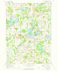 1971 Somerset Center1973 Print · USGSThe Jackson and Hillsdale county line in the early 1970s shows a landscape of small settlements and interconnected glacial lakes. Genealogists and local historians can locate Patch Cemetery, trace the Old Railroad Grade, and explore the village of Jerome.2 unique versions available
 - 1971 Map of Jackson South, 1973 Print
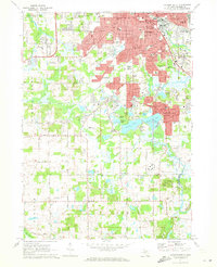 1971 Jackson South1973 Print · USGSJackson and its southern suburbs were expanding during the early 1970s as new campus facilities and parks reshaped the landscape. Researchers can trace local heritage at St Johns Cemetery, Jackson Community College, and the old rail corridor of the Penn Central.3 unique versions available
End of results
Showing maps 1-2 of 2
Top cities near Hanover Township
- Jackson historical maps
- Albion historical maps
- Spring Arbor Township historical maps
- Hillsdale historical maps
- Vandercook Lake historical maps
- Somerset historical maps
See more
Top neighborhoods of Hanover Township
- Stoney Point historical maps
- Horton historical maps
- Hanover historical maps
- Clearwater Subdivision historical maps
- Lake Marie Subdivision historical maps
Frequently asked questions
- What are the different types of historical maps available for Hanover Township?
- What is the oldest map of Hanover Township?
- Where can I purchase historical maps of Hanover Township for my home or office?
- Where can I download high-res historical maps of Hanover Township?
- Are there historical topographic maps available for Hanover Township?
- Is there historical aerial imagery available for Hanover Township?
- Where are historical maps of Hanover Township sourced from?