1940s Maps of Kent County, Michigan
Explore 4 historic maps of Kent County from the 1940s. These maps offer a rare glimpse into what life looked like during the 1940s — showing old roads, neighborhoods, homes, and landmarks that have changed or disappeared over time.
Whether you're researching your family's past, planning a metal detecting trip, or studying how Kent County's landscape evolved across the 1940s, these high-resolution maps are a powerful tool for exploring the history of this region.
- Focus on a specific era: All maps on this page are from the 1940s, giving you a focused view of this time period.
- See what’s changed: Compare century-old streets, trails, and buildings to today's modern landscape using overlays and satellite layers.
- Research with precision: Use these maps for genealogy, historical research, land use analysis, or educational projects.
- View, download, or print: Maps are fully viewable online in high resolution, and can be downloaded or printed for your own records.
Start exploring Kent County's history through authentic maps from the 1940s. This is your window into the past.
Kent County, MI maps
(4)- 1943 Map of Cedar Springs
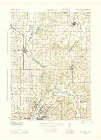 1943 Cedar Springs1943 Print · USGSKent County during the early 1940s reveals a thriving network of rail-side towns and rural school districts before postwar expansion changed the landscape. Genealogists and historians can trace family locations near Christian Hill Sch, Childsdale, and the numerous family-named landmarks like Johnston Corners.
 - 1943 Map of Grand Rapids
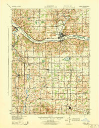
 1943 Grand Rapids1943 Print · USGSGrand Rapids and its surrounding Kent County townships are captured here in the early 1940s, showing a landscape defined by river industry and rail expansion. Genealogists can trace family roots through dozens of named rural schools like Sodom Sch, the County Farm, and early settlements like Byron Center.
 - 1943 Map of Lowell, 1944 Print
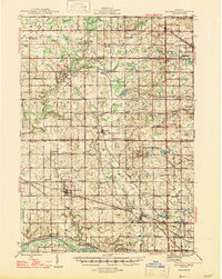
 1943 Lowell1944 Print · USGSCentral Michigan river valleys and rural townships are captured here during the early 1940s. Genealogists can locate numerous namesake schoolhouses like Yerkes Sch and Cooke Sch, or trace the rail lines through Alto and Fallassburg.
 - 1945 Map of Ravenna, 1947 Print
 1945 Ravenna1947 Print · USGSNear the close of the war years, this area north of the Grand River was a bustling network of small farming towns and rural school districts. Genealogists and local historians can trace the foundations of Coopersville, Ravenna, and Conklin, or locate family sites near McNitt Cem and Hoogstraat Sch.3 unique versions available
End of results
Showing maps 1-4 of 4
Top cities of Kent County
- Grand Rapids historical maps
- Wyoming historical maps
- Kentwood historical maps
- Plainfield Charter Township historical maps
- Gaines Charter Township historical maps
- Byron Township historical maps
See more
Frequently asked questions
- What are the different types of historical maps available for Kent County?
- What is the oldest map of Kent County?
- Where can I purchase historical maps of Kent County for my home or office?
- Where can I download high-res historical maps of Kent County?
- Are there historical topographic maps available for Kent County?
- Is there historical aerial imagery available for Kent County?
- Where are historical maps of Kent County sourced from?