1960s Maps of Kent County, Michigan
Explore 11 historic maps of Kent County from the 1960s. These maps offer a rare glimpse into what life looked like during the 1960s — showing old roads, neighborhoods, homes, and landmarks that have changed or disappeared over time.
Whether you're researching your family's past, planning a metal detecting trip, or studying how Kent County's landscape evolved across the 1960s, these high-resolution maps are a powerful tool for exploring the history of this region.
- Focus on a specific era: All maps on this page are from the 1960s, giving you a focused view of this time period.
- See what’s changed: Compare century-old streets, trails, and buildings to today's modern landscape using overlays and satellite layers.
- Research with precision: Use these maps for genealogy, historical research, land use analysis, or educational projects.
- View, download, or print: Maps are fully viewable online in high resolution, and can be downloaded or printed for your own records.
Start exploring Kent County's history through authentic maps from the 1960s. This is your window into the past.
Kent County, MI maps
(11)- 1961 Map of Grand Rapids
 1961 Grand Rapids1961 Print · USGSSouthern Michigan at the dawn of the 1960s reveals a region shaped by major river systems and a robust rail network. Trace mid-century industrial growth and land use from Grand Rapids to the Fort Custer Military Reservation and Gun Lake.
 - 1962 Map of Grand Rapids
 1962 Grand Rapids1962 Print · USGSMid-century Southern Michigan is mapped here at a time of massive growth, showing the expanding urban footprints of Grand Rapids and Lansing. Researchers can trace the legacy of the Grand Trunk Western RR, find historic boundaries of the Fort Custer Military Reservation, or locate sporting camps around Gun Lake.2 unique versions available
 - 1966 Map of Midland
 1966 Midland1966 Print · USGSCentral Michigan in the mid-1960s shows a landscape of growing manufacturing hubs and active resource extraction. Genealogists and historians can trace the rail corridors of the Grand Trunk Western or locate family-named landmarks near Oil wells and the Muskegon River.
 - 1967 Map of Sparta, 1969 Print
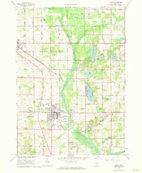 1967 Sparta1969 Print · USGSKent County during the late sixties shows a landscape of small farms and lakeside communities connected by the Chesapeake and Ohio Railroad. Trace local history through Idlewild Cem, Christian Hill Sch, and the Sparta Airport.2 unique versions available
 - 1967 Map of Grand Rapids West, 1969 Print
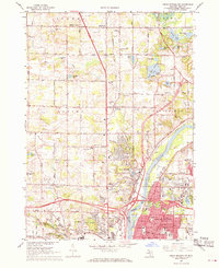
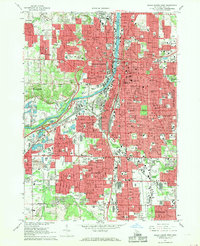 1967 Grand Rapids West1969 Print · USGSThe Grand Rapids metropolitan area comes alive in the late sixties, showing the dense growth of Wyoming and Walker along the Grand River. Researchers can trace parish histories at St Andrews Cemetery or locate old industrial landmarks like the Kent Industrial Center.4 unique versions available
 - 1967 Map of Grand Rapids East, 1969 Print
 1967 Grand Rapids East1969 Print · USGSEastern Kent County during the late sixties shows a landscape in transition as suburbs press toward the Thornapple River. Genealogists and historians can trace institutional roots at Calvin Knollerest College, Woodlawn Cemetery, and the Kent County Airport.4 unique versions available
 - 1967 Map of Cedar Springs, 1969 Print
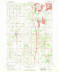
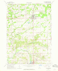 1967 Cedar Springs1969 Print · USGSNorthern Kent County in the late sixties reveals a network of railroad towns and farming townships connected by a strict section-line grid. Researchers can trace the Penn Central line through Cedar Springs, locate family plots at Punches Cem, and find old school sites like Algoma Sch.2 unique versions available
 - 1967 Map of Cedar Springs SW, 1969 Print
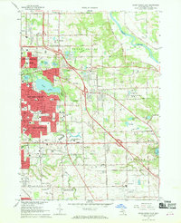
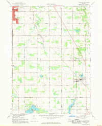
 1967 Cedar Springs SW1969 Print · USGSThe northern edges of Grand Rapids meet the countryside in the late sixties, showing the suburban expansion into Walker and Alpine. Genealogists and historians can trace family plots at Holy Trinity Cem or locate former schoolhouses like Koon Sch and Wheeler Sch.3 unique versions available
 - 1967 Map of Cutlerville, 1969 Print
 1967 Cutlerville1969 Print · USGSThe southern suburbs of Grand Rapids transition into Kent County farmland during the late sixties. Researchers can trace the development of Cutlerville and Byron Center alongside historic sites like Winchester Cem and Pine Hill.3 unique versions available
 - 1967 Map of Rockford, 1969 Print
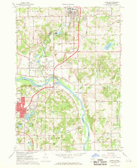 1967 Rockford1969 Print · USGSThe Rogue and Grand Rivers meet in this 1960s portrait of Kent County as it transitioned from rural townships to growing suburbs. Trace local roots at Rockford Cem, Childsdale, and the old Egypt Valley Sch.3 unique versions available
 - 1967 Map of Caledonia, 1969 Print
 1967 Caledonia1969 Print · USGSThe area around Caledonia and Dutton is documented in the late 1960s as suburban growth begins to meet the rural landscape. Trace the Penn Central rail line and locate community landmarks like Holy Corners, Gaines Sch, and Hanna Lake.3 unique versions available
End of results
Showing maps 1-11 of 11
Top cities of Kent County
- Grand Rapids historical maps
- Wyoming historical maps
- Kentwood historical maps
- Plainfield Charter Township historical maps
- Gaines Charter Township historical maps
- Byron Township historical maps
See more
Frequently asked questions
- What are the different types of historical maps available for Kent County?
- What is the oldest map of Kent County?
- Where can I purchase historical maps of Kent County for my home or office?
- Where can I download high-res historical maps of Kent County?
- Are there historical topographic maps available for Kent County?
- Is there historical aerial imagery available for Kent County?
- Where are historical maps of Kent County sourced from?