Old Maps of Grant Township, Michigan for Metal Detecting
Plan your next treasure hunt with 62 historic maps of Grant Township. Find old homesites, ghost towns, trails, and gathering spots that may be lost to time — perfect for identifying promising metal detecting locations.
- Locate forgotten sites: Uncover places like long-lost settlements, abandoned rail lines, or gathering spots.
- Plan better hunts: Use map overlays combined with LiDAR or satellite views to narrow in on historically rich areas.
- Made for detectorists: Thousands of hobbyists use these maps to discover relics, coins, and hidden history.
Use these historic maps to boost your research and find new opportunities beneath the surface of Grant Township.
Grant Township, MI maps
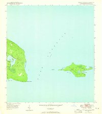
(62)- 1927 Map of Point Isabelle
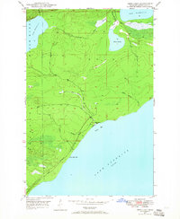
 1927 Point Isabelle1927 Print · USGSThe southern coast of the Keweenaw Peninsula is captured here in the late 1930s, documenting the remote shoreline before major modern changes. Trace the maritime history of Mendota through landmarks like the Mendota L H and the Mendota Canal.
 - 1938 Map of Delaware
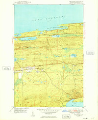
 1938 Delaware1938 Print · USGSThe Keweenaw Peninsula in the late 1930s shows a landscape of mining-era remnants and early coastal tourism. Genealogists and historians can trace the small settlements of Delaware and Mandan, or follow the Old Railroad Grade past Lac La Belle.
 - 1939 Map of Deer Lake
 1939 Deer Lake1939 Print · USGSThe Keweenaw Peninsula shore in the late thirties shows a landscape of remote schools and winding river systems. Trace early landmarks like the Betsy River Sch, the waters of Lac La Belle, and the rocky shoreline at Black Rock Pt.
 - 1939 Map of Delaware
 1939 Delaware1939 Print · USGSKeweenaw's copper country is shown in the late thirties, featuring the inland settlements and dramatic shoreline ridges. Trace the industrial landscape through the old Railroad Grade at Delaware and the scenic Brockway Mountain Drive.
 - 1940 Map of Deer Lake
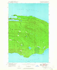
 1940 Deer Lake1940 Print · USGSThe Keweenaw Peninsula shoreline comes alive in the late 1930s as aerial photography reveals the remote coastal reaches of Lake Superior. Researchers can trace the drainage of the Big Betsy River or locate the site of the Betsy River Sch and Black Rock Pt.
 - 1940 Map of Manitou Island
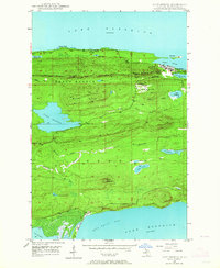
 1940 Manitou Island1940 Print · USGSThe tip of Michigan's Keweenaw Peninsula and the outlying Manitou Island are shown in 1940 just before the war. Marine historians and local researchers can locate navigation landmarks like the Manitou Island L H and Gull Rock L H.
 - 1940 Map of Fort Wilkins
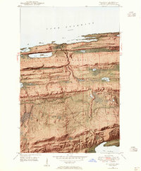
 1940 Fort Wilkins1940 Print · USGSThe northern tip of the Keweenaw Peninsula is captured here in the late 1930s as the region's wilderness and maritime history began to be preserved. Researchers can trace the layout of Fort Wilkins State Park and locate landmarks like the Copper Harbor L H and Keystone Pt.2 unique versions available
 - 1940 Map of Lake Medora
 1940 Lake Medora1940 Print · USGSKeweenaw's rugged northern tip is captured in the 1940s as a landscape of mining history and new tourism. Trace the early routes of Brockway Mountain Drive and find the site of Aetna near Lake Manganese.
 - 1948 Map of Delaware, 1955 Print
 1948 Delaware1955 Print · USGSKeweenaw County’s rugged northern tip appears in the late 1940s, from the rocky harbor at Agate Point down to the settlement at Delaware. You can trace the complex geography of the Montreal River valley and find early mining-era sites like Mandan and Lac La Belle.8 unique versions available
 - 1948 Map of Lake Medora, 1964 Print
 1948 Lake Medora1964 Print · USGSThe Keweenaw Peninsula's northern coast appears here in the late 1940s, balancing its mining history with emerging tourism. Researchers can trace the winding Brockway Mountain Drive and find landmarks like Ft Wilkins State Park and Mount Houghton.3 unique versions available
 - 1948 Map of Fort Wilkins, 1964 Print
 1948 Fort Wilkins1964 Print · USGSThe tip of the Keweenaw Peninsula in the late 1940s reflects a landscape shaped by military history and the waning copper industry. Researchers can locate Old Fort Wilkins, the Copper Harbor Lighthouse, and a Copper Mine (Abandoned).3 unique versions available
 - 1948 Map of Manitou Island, 1965 Print
 1948 Manitou Island1965 Print · USGSKeweenaw Peninsula's easternmost reaches appear here in the late 1940s, highlighting the isolated lighthouse outposts in Lake Superior. Maritime researchers can trace the vital navigation points at Manitou Island Lighthouse and Gull Rock Lighthouse.4 unique versions available
 - 1948 Map of Deer Lake, 1965 Print
 1948 Deer Lake1965 Print · USGSKeweenaw's rugged shoreline and interior waterways are captured here in the late 1940s as a new coastal road was first being carved. Researchers can trace the early path of the road UNDER CONSTRUCTION near Black Rock Point or locate the site of the Betsy River School.3 unique versions available
 - 1948 Map of Point Isabelle, 1968 Print
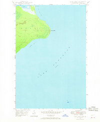 1948 Point Isabelle1968 Print · USGSThe Keweenaw Peninsula coast is captured here just after the war, showing the vital maritime link between the Great Lakes and inland waters. Researchers can trace the navigation route through the Mendota Canal and locate the Mendota Light House.2 unique versions available
 - 1949 Map of Manitou Island
 1949 Manitou Island1949 Print · USGSThe northernmost tip of Michigan's Keweenaw Peninsula is captured here in the late 1940s, highlighting the lonely outposts of Lake Superior navigation. Genealogists and maritime historians can trace the remote Gull Rock Lighthouse and the vital Manitou Island L H at the edge of Fishermans Bay.
 - 1949 Map of Fort Wilkins
 1949 Fort Wilkins1949 Print · USGSThe northern tip of Michigan's Keweenaw Peninsula is shown here in the late 1940s, featuring the historic outpost of Old Fort Wilkins. Researchers can locate the Copper Harbor Lighthouse and trace the shorelines of Lake Fanny Hooe and Keystone Bay.2 unique versions available
 - 1949 Map of Deer Lake
 1949 Deer Lake1949 Print · USGSKeweenaw Peninsula wilderness meets the coast of Lake Superior in the late 1940s. Genealogists and researchers can locate the Betsy River Sch and trace the early development of roads under construction near Black Rock Point.
 - 1949 Map of Lake Medora
 1949 Lake Medora1949 Print · USGSThe tip of Michigan's Keweenaw Peninsula comes alive in this late 1940s survey of the northern copper country. Trace the historic grounds of Ft Wilkins State Park, the heights of Mount Houghton, and the remote coastal settlement at Bete Grise.
 - 1949 Map of Delaware
 1949 Delaware1949 Print · USGSThe Keweenaw Peninsula’s rugged northern coast and interior ridges are captured here just after the war. Genealogists and local historians can locate the early settlements of Delaware and Mandan or trace the winding Montreal River toward Lac La Belle.4 unique versions available
 - 1949 Map of Point Isabelle
 1949 Point Isabelle1949 Print · USGSThe Keweenaw Peninsula shoreline comes into focus in the late 1940s, highlighting the remote maritime landscape of Lake Superior. Researchers can trace the navigation route through the Mendota Canal past the Mendota Light House and around the landmark of Point Isabelle.
 - 1958 Map of Hancock, 1967 Print
 1958 Hancock1967 Print · USGSThe Keweenaw Peninsula and Isle Royale are seen here during the mid-twentieth century as mining and maritime hubs. Trace the dense town layouts of Hancock and Calumet, or locate remote coastal markers like the Eagle Harbor Lighthouse and Rock of Ages Light.2 unique versions available
 - 1960 Map of Hancock
 1960 Hancock1960 Print · USGSThe Keweenaw Peninsula and Isle Royale are captured in detail during the late 1950s. Researchers can trace copper-mining era settlements like Calumet and Laurium, or locate remote maritime landmarks such as the Isle Royale Lighthouse.
 - 1961 Map of Hancock
 1961 Hancock1961 Print · USGSThe Keweenaw Peninsula and Isle Royale are shown here at the start of the 1960s, featuring the region's historic copper mining and maritime infrastructure. Genealogists and researchers can trace local families through settlements like Atlantic Mine and Painesdale, or locate remote landmarks including Rock of Ages Light and Eagle Harbor.
 - 1966 Map of Hancock, 1987 Print
 1966 Hancock1987 Print · USGSThe Keweenaw Peninsula and Isle Royale are captured in the mid-1960s during a pivotal era for Michigan’s Copper Country. Trace the industrial footprint of the SOO LINE through Calumet or locate historic maritime landmarks like Fort Wilkins and Rock of Ages Light.
 - 1985 Map of Copper Harbor
 1985 Copper Harbor1985 Print · USGSThe northern tip of the Keweenaw Peninsula is captured in the mid-eighties, showing the rugged shoreline from Bete Grise to Keweenaw Point. Local historians can trace landmarks like Ft Wilkins State Park, Mount Houghton, and the isolated Manitou Island lighthouse.2 unique versions available
Showing maps 1-25 of 62
Top neighborhoods of Grant Township
- Bete Grise historical maps
- Betsy historical maps
- Delaware historical maps
- Little Betsy historical maps
- Mandan historical maps
- South Point historical maps
See more
Frequently asked questions
- What are the different types of historical maps available for Grant Township?
- What is the oldest map of Grant Township?
- Where can I purchase historical maps of Grant Township for my home or office?
- Where can I download high-res historical maps of Grant Township?
- Are there historical topographic maps available for Grant Township?
- Is there historical aerial imagery available for Grant Township?
- Where are historical maps of Grant Township sourced from?