1940s Maps of Houghton Township, Michigan
Explore 10 historic maps of Houghton Township from the 1940s. These maps offer a rare glimpse into what life looked like during the 1940s — showing old roads, neighborhoods, homes, and landmarks that have changed or disappeared over time.
Whether you're researching your family's past, planning a metal detecting trip, or studying how Houghton Township's landscape evolved across the 1940s, these high-resolution maps are a powerful tool for exploring the history of this region.
- Focus on a specific era: All maps on this page are from the 1940s, giving you a focused view of this time period.
- See what’s changed: Compare century-old streets, trails, and buildings to today's modern landscape using overlays and satellite layers.
- Research with precision: Use these maps for genealogy, historical research, land use analysis, or educational projects.
- View, download, or print: Maps are fully viewable online in high resolution, and can be downloaded or printed for your own records.
Start exploring Houghton Township's history through authentic maps from the 1940s. This is your window into the past.
Houghton Township, MI maps
(10)- 1940 Map of Central
 1940 Central1940 Print · USGSKeweenaw Peninsula's rugged copper country comes into focus in this pre-war survey of the Lake Superior coastline. Genealogists and historians can trace the legacy of mining at Central and Copper Falls or locate the historic Eagle Harbor L H and the local Central Fire Tower.
 - 1941 Map of Mohawk
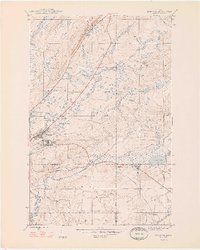
 1941 Mohawk1941 Print · USGSThe Keweenaw Peninsula's copper country comes into focus just before World War II, showing a landscape shaped by mining and rail. Researchers can trace the industrial corridor from Mohawk to Hebards via the Keweenaw Central Railroad and find the Gratiot Mine.
 - 1946 Map of Phoenix, 1965 Print
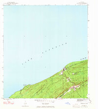 1946 Phoenix1965 Print · USGSThe Keweenaw Peninsula’s northern shore in the 1940s reveals a mix of maritime infrastructure and copper-era transport. Researchers can trace the path of the Keweenaw Central Railroad or locate the Eagle River Cem and the coastal Sand Hills Lighthouse Coast Guard Sta.4 unique versions available
 - 1946 Map of Bruneau Creek, 1967 Print
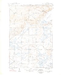
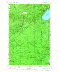 1946 Bruneau Creek1967 Print · USGSThe Keweenaw Peninsula interior comes into focus during the mid-forties, showing the wild drainage basins between Houghton and Sherman. Trace the intricate water networks of Lake Gratiot, the slopes of Mt Horace Greeley, and the headwaters of the Tobacco River.3 unique versions available
 - 1946 Map of Mohawk, 1967 Print
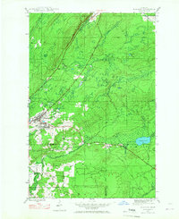 1946 Mohawk1967 Print · USGSThe copper country of the Keweenaw Peninsula is captured here in the mid-1940s as mining and rail operations defined the local economy. Genealogists and industrial historians can trace the footprint of the Gratiot Mine, the Calumet and Hecla RR, and company towns like Mohawk and Fulton.3 unique versions available
 - 1946 Map of Eagle Harbor, 1968 Print
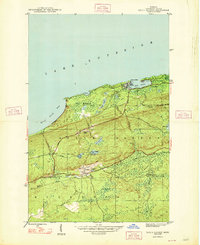
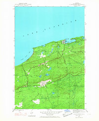 1946 Eagle Harbor1968 Print · USGSThe Keweenaw Peninsula coastline in the mid-1940s reveals a landscape defined by maritime safety and the aging infrastructure of the copper boom. Researchers can locate the Eagle Harbor L H, trace the Old Railroad Grade, and find inland mining-era sites like Copper Falls and Central.3 unique versions available
 - 1947 Map of Phoenix
 1947 Phoenix1947 Print · USGSKeweenaw copper country meets the Lake Superior shore in the mid-1940s, showing the early post-war industrial landscape. Genealogists and historians can trace family ties at Eagle River Cem, locate the Coast Guard Sta, or follow the Old Railroad Grade past Phoenix.
 - 1948 Map of Mohawk
 1948 Mohawk1948 Print · USGSCopper mining and rail transport dominate the Keweenaw Peninsula in the late 1940s as industry follows the mineral-rich ridges. Genealogists and historians can trace the street grids of Mohawk and Fulton or locate industrial sites like the Gratiot Mine and the Hecla and Torch Lake RR.2 unique versions available
 - 1948 Map of Eagle Harbor
 1948 Eagle Harbor1948 Print · USGSThe Keweenaw Peninsula's rugged mining and maritime culture is on full display in the late 1940s. Genealogists and historians can trace the foundations of Central and Copper Falls, or locate family sites near Pine Grove Cem and the Coast Guard Sta.2 unique versions available
 - 1948 Map of Bruneau Creek
 1948 Bruneau Creek1948 Print · USGSKeweenaw's rugged northern interior and Lake Superior shoreline are captured here in the late 1940s. Researchers can trace the winding paths of Bruneau Creek and the Tobacco River or locate the summit of Mt Horace Greeley.2 unique versions available
End of results
Showing maps 1-10 of 10
Top neighborhoods of Houghton Township
Frequently asked questions
- What are the different types of historical maps available for Houghton Township?
- What is the oldest map of Houghton Township?
- Where can I purchase historical maps of Houghton Township for my home or office?
- Where can I download high-res historical maps of Houghton Township?
- Are there historical topographic maps available for Houghton Township?
- Is there historical aerial imagery available for Houghton Township?
- Where are historical maps of Houghton Township sourced from?