1960s Maps of Burlington Township, Michigan
Explore 4 historic maps of Burlington Township from the 1960s. These maps offer a rare glimpse into what life looked like during the 1960s — showing old roads, neighborhoods, homes, and landmarks that have changed or disappeared over time.
Whether you're researching your family's past, planning a metal detecting trip, or studying how Burlington Township's landscape evolved across the 1960s, these high-resolution maps are a powerful tool for exploring the history of this region.
- Focus on a specific era: All maps on this page are from the 1960s, giving you a focused view of this time period.
- See what’s changed: Compare century-old streets, trails, and buildings to today's modern landscape using overlays and satellite layers.
- Research with precision: Use these maps for genealogy, historical research, land use analysis, or educational projects.
- View, download, or print: Maps are fully viewable online in high resolution, and can be downloaded or printed for your own records.
Start exploring Burlington Township's history through authentic maps from the 1960s. This is your window into the past.
Burlington Township, MI maps
(4)- 1963 Map of Clifford, 1964 Print
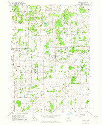 1963 Clifford1964 Print · USGSLife on the Tuscola and Lapeer county line in the early sixties centered on rail-connected villages and a network of rural schools. Genealogists and historians can trace the foundations of Silverwood, Clifford, and landmarks like St Patricks Cem or the Maple Grove Sch.
 - 1963 Map of Marlette, 1964 Print
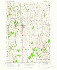 1963 Marlette1964 Print · USGSMarlette and the surrounding farm country are captured here in the early sixties as the regional rail and drainage networks were fully matured. Genealogists and local historians can trace rural school districts like Brown School and Montgomery Sch or locate family sites near French Line Presbyterian Ch.2 unique versions available
 - 1963 Map of North Branch, 1964 Print
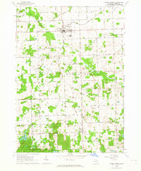 1963 North Branch1964 Print · USGSLapeer County agriculture and rural life are captured here in the early sixties, centered on the village of North Branch. Genealogists can trace family names through landmarks like SS Peter and Paul Cem, Kings Mill, and the Five Lakes Sch.2 unique versions available
 - 1963 Map of Burnside, 1964 Print
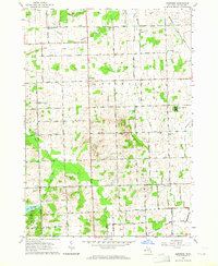 1963 Burnside1964 Print · USGSLapeer County's rural townships are documented in the early sixties, showing the agricultural network of Burnside and Goodland. Local historians can trace family-named schools and cemeteries like Abbott Sch, Fox Cem, and the mid-century Drive-in Theater.2 unique versions available
End of results
Showing maps 1-4 of 4
Top cities near Burlington Township
- Lapeer historical maps
- Caro historical maps
- Burnside historical maps
- Marlette historical maps
- Dayton historical maps
- Goodland historical maps
See more
Top neighborhoods of Burlington Township
Frequently asked questions
- What are the different types of historical maps available for Burlington Township?
- What is the oldest map of Burlington Township?
- Where can I purchase historical maps of Burlington Township for my home or office?
- Where can I download high-res historical maps of Burlington Township?
- Are there historical topographic maps available for Burlington Township?
- Is there historical aerial imagery available for Burlington Township?
- Where are historical maps of Burlington Township sourced from?