1960s Maps of Mayfield Township, Michigan
Explore 4 historic maps of Mayfield Township from the 1960s. These maps offer a rare glimpse into what life looked like during the 1960s — showing old roads, neighborhoods, homes, and landmarks that have changed or disappeared over time.
Whether you're researching your family's past, planning a metal detecting trip, or studying how Mayfield Township's landscape evolved across the 1960s, these high-resolution maps are a powerful tool for exploring the history of this region.
- Focus on a specific era: All maps on this page are from the 1960s, giving you a focused view of this time period.
- See what’s changed: Compare century-old streets, trails, and buildings to today's modern landscape using overlays and satellite layers.
- Research with precision: Use these maps for genealogy, historical research, land use analysis, or educational projects.
- View, download, or print: Maps are fully viewable online in high resolution, and can be downloaded or printed for your own records.
Start exploring Mayfield Township's history through authentic maps from the 1960s. This is your window into the past.
Mayfield Township, MI maps
(4)- 1963 Map of Attica, 1964 Print
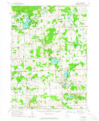 1963 Attica1964 Print · USGSLapeer County's rural landscape is captured here in the early sixties, showing a transition between agricultural tradition and local recreation. Genealogists and historians can trace family roots through several district schoolhouses like Fish Lake Sch and the small settlements of Lum and Attica.2 unique versions available
 - 1963 Map of North Branch, 1964 Print
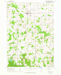 1963 North Branch1964 Print · USGSLapeer County agriculture and rural life are captured here in the early sixties, centered on the village of North Branch. Genealogists can trace family names through landmarks like SS Peter and Paul Cem, Kings Mill, and the Five Lakes Sch.2 unique versions available
 - 1963 Map of Barnes Lake, 1964 Print
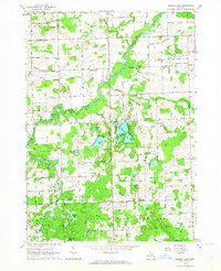 1963 Barnes Lake1964 Print · USGSThe Lapeer and Tuscola county line area is captured here during the early sixties, a landscape of extensive state game lands and winding river branches. Local historians can trace family roots at West Deerfield Ch or locate mid-century landmarks like Sweet Sch and Millers Lake.2 unique versions available
 - 1963 Map of Lapeer, 1964 Print
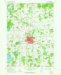 1963 Lapeer1964 Print · USGSLapeer and its surrounding townships are shown here in the early sixties as a center for regional institutions and rural education. Genealogists can locate family landmarks like Mt Loretto Cem and numerous district schools such as Valentine Sch and Irwin Sch.2 unique versions available
End of results
Showing maps 1-4 of 4
Top cities near Mayfield Township
- Oxford Charter Township historical maps
- Lapeer historical maps
- Addison Township historical maps
- Elba historical maps
- Davison historical maps
- Attica historical maps
See more
Frequently asked questions
- What are the different types of historical maps available for Mayfield Township?
- What is the oldest map of Mayfield Township?
- Where can I purchase historical maps of Mayfield Township for my home or office?
- Where can I download high-res historical maps of Mayfield Township?
- Are there historical topographic maps available for Mayfield Township?
- Is there historical aerial imagery available for Mayfield Township?
- Where are historical maps of Mayfield Township sourced from?