1960s Maps of Seneca Township, Michigan
Explore 4 historic maps of Seneca Township from the 1960s. These maps offer a rare glimpse into what life looked like during the 1960s — showing old roads, neighborhoods, homes, and landmarks that have changed or disappeared over time.
Whether you're researching your family's past, planning a metal detecting trip, or studying how Seneca Township's landscape evolved across the 1960s, these high-resolution maps are a powerful tool for exploring the history of this region.
- Focus on a specific era: All maps on this page are from the 1960s, giving you a focused view of this time period.
- See what’s changed: Compare century-old streets, trails, and buildings to today's modern landscape using overlays and satellite layers.
- Research with precision: Use these maps for genealogy, historical research, land use analysis, or educational projects.
- View, download, or print: Maps are fully viewable online in high resolution, and can be downloaded or printed for your own records.
Start exploring Seneca Township's history through authentic maps from the 1960s. This is your window into the past.
Seneca Township, MI maps
(4)- 1960 Map of Morenci, 1961 Print
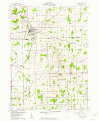 1960 Morenci1961 Print · USGSMorenci and the surrounding borderlands of Michigan and Ohio are shown here in the early sixties, as rail lines and rural townships defined the local economy. Genealogists can trace family names through Oak Grove Cemetery, East Chesterfield Ch, and the crossroads at Oakshade.3 unique versions available
 - 1960 Map of Lyons, 1961 Print
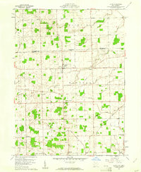 1960 Lyons1961 Print · USGSNorthwest Ohio's borderlands are mapped here in the early sixties, showing the rural landscape around Lyons and Winameg. Researchers can trace old family sites and transit routes including the Detroit Toledo and Ironton railroad, Rose Hill Cem, and Tubbs Sch.3 unique versions available
 - 1962 Map of Clayton, 1963 Print
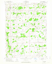 1962 Clayton1963 Print · USGSLenawee County’s rural townships are captured here in the early sixties, showing a landscape defined by rail lines and reclaimed farmland. Family historians can locate specific sites like South Dover Cem, Dover Center Ch, and the Grange Hall.3 unique versions available
 - 1962 Map of Jasper, 1963 Print
 1962 Jasper1963 Print · USGSSouthern Michigan's farm country near the Ohio line comes into focus in this early sixties survey. Genealogists can trace family names along Hoadley Dr and Anderson Dr, while exploring local hubs like Weston and Jasper along the New York Central Railroad.2 unique versions available
End of results
Showing maps 1-4 of 4
Top cities near Seneca Township
- Adrian historical maps
- Wauseon historical maps
- Archbold historical maps
- Rollin Township historical maps
- Rollin historical maps
- Delta historical maps
See more
Top neighborhoods of Seneca Township
Frequently asked questions
- What are the different types of historical maps available for Seneca Township?
- What is the oldest map of Seneca Township?
- Where can I purchase historical maps of Seneca Township for my home or office?
- Where can I download high-res historical maps of Seneca Township?
- Are there historical topographic maps available for Seneca Township?
- Is there historical aerial imagery available for Seneca Township?
- Where are historical maps of Seneca Township sourced from?