1960s Maps of Tecumseh Township, Michigan
Explore 7 historic maps of Tecumseh Township from the 1960s. These maps offer a rare glimpse into what life looked like during the 1960s — showing old roads, neighborhoods, homes, and landmarks that have changed or disappeared over time.
Whether you're researching your family's past, planning a metal detecting trip, or studying how Tecumseh Township's landscape evolved across the 1960s, these high-resolution maps are a powerful tool for exploring the history of this region.
- Focus on a specific era: All maps on this page are from the 1960s, giving you a focused view of this time period.
- See what’s changed: Compare century-old streets, trails, and buildings to today's modern landscape using overlays and satellite layers.
- Research with precision: Use these maps for genealogy, historical research, land use analysis, or educational projects.
- View, download, or print: Maps are fully viewable online in high resolution, and can be downloaded or printed for your own records.
Start exploring Tecumseh Township's history through authentic maps from the 1960s. This is your window into the past.
Tecumseh Township, MI maps
(7)- 1961 Map of Grand Rapids
 1961 Grand Rapids1961 Print · USGSSouthern Michigan at the dawn of the 1960s reveals a region shaped by major river systems and a robust rail network. Trace mid-century industrial growth and land use from Grand Rapids to the Fort Custer Military Reservation and Gun Lake.
 - 1961 Map of Toledo
 1961 Toledo1961 Print · USGSThe western basin of Lake Erie and the industrial heart of Northern Ohio are captured here during the post-war era. Researchers can trace historical rail lines like the New York Central or locate landmarks like the Erie Ordnance Depot and Pelee Island.
 - 1961 Map of Detroit, 1973 Print
 1961 Detroit1973 Print · USGSThe international border between Michigan and Ontario was a bustling industrial corridor in the early sixties. Researchers can trace the transit networks and riverfront infrastructure connecting Detroit to Windsor via the Detroit-Windsor Tunnel and major air hubs like Willow Run Airport.2 unique versions available
 - 1962 Map of Grand Rapids
 1962 Grand Rapids1962 Print · USGSMid-century Southern Michigan is mapped here at a time of massive growth, showing the expanding urban footprints of Grand Rapids and Lansing. Researchers can trace the legacy of the Grand Trunk Western RR, find historic boundaries of the Fort Custer Military Reservation, or locate sporting camps around Gun Lake.2 unique versions available
 - 1962 Map of Adrian, 1963 Print
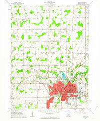 1962 Adrian1963 Print · USGSAdrian was a bustling rail and educational center in the early sixties, defined by its river crossings and expanding industrial footprint. Genealogists and historians can trace the campuses of Adrian College and Siena Heights College or locate family plots in Oakwood Cemetery and St Johns Cem.4 unique versions available
 - 1965 Map of Detroit
 1965 Detroit1965 Print · USGSThe industrial corridor between Michigan and Ontario is captured here at mid-century, showing the dense rail and river networks of the Great Lakes. Local historians can trace the paths of the Grand Trunk Western RR and locate key landmarks like Selfridge Air Force Base and Grosse Ile.
 - 1967 Map of Tecumseh North, 1969 Print
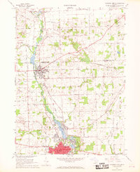 1967 Tecumseh North1969 Print · USGSThe River Raisin valley comes into sharp focus during the late sixties, capturing the expansion of Tecumseh and Clinton. Family historians can trace local roots through Brookside Cemetery, schools like Patterson Sch, and the tracks of the Penn Central railroad.2 unique versions available
End of results
Showing maps 1-7 of 7
Top cities near Tecumseh Township
- Ann Arbor historical maps
- Pittsfield Charter Township historical maps
- Adrian historical maps
- York Charter Township historical maps
- Saline historical maps
- Tecumseh historical maps
See more
Frequently asked questions
- What are the different types of historical maps available for Tecumseh Township?
- What is the oldest map of Tecumseh Township?
- Where can I purchase historical maps of Tecumseh Township for my home or office?
- Where can I download high-res historical maps of Tecumseh Township?
- Are there historical topographic maps available for Tecumseh Township?
- Is there historical aerial imagery available for Tecumseh Township?
- Where are historical maps of Tecumseh Township sourced from?