1950s Maps of Mackinac County, Michigan
Explore 12 historic maps of Mackinac County from the 1950s. These maps offer a rare glimpse into what life looked like during the 1950s — showing old roads, neighborhoods, homes, and landmarks that have changed or disappeared over time.
Whether you're researching your family's past, planning a metal detecting trip, or studying how Mackinac County's landscape evolved across the 1950s, these high-resolution maps are a powerful tool for exploring the history of this region.
- Focus on a specific era: All maps on this page are from the 1950s, giving you a focused view of this time period.
- See what’s changed: Compare century-old streets, trails, and buildings to today's modern landscape using overlays and satellite layers.
- Research with precision: Use these maps for genealogy, historical research, land use analysis, or educational projects.
- View, download, or print: Maps are fully viewable online in high resolution, and can be downloaded or printed for your own records.
Start exploring Mackinac County's history through authentic maps from the 1950s. This is your window into the past.
Mackinac County, MI maps
(12)- 1953 Map of Pickford NW, 1955 Print
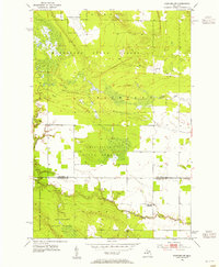 1953 Pickford NW1955 Print · USGSThe Upper Peninsula landscape in the early fifties shows a region defined by cold-war aviation and deep woods. Researchers can find Cottle Cem, the Blair Sch, and the footprint of Kinross Air Force Base.3 unique versions available
 - 1953 Map of Rudyard, 1955 Print
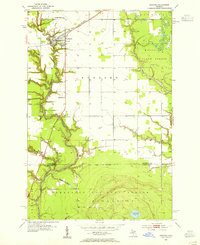 1953 Rudyard1955 Print · USGSNorthern Michigan's Upper Peninsula comes to life in this mid-century survey of the Rudyard area. Genealogists and local historians can trace family-named landmarks like the S Rudyard Cem and Apostolic Ch along the North Fork Pine River.2 unique versions available
 - 1953 Map of Pickford, 1955 Print
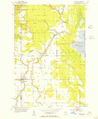 1953 Pickford1955 Print · USGSEastern Upper Peninsula life in the early fifties centers on the rural community of Pickford and the surrounding timberlands. Genealogists and historians can locate family landmarks like Fairview Cem, St Mathias Ch, and the lost hamlet of Stirlingville.4 unique versions available
 - 1953 Map of Fibre, 1955 Print
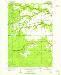 1953 Fibre1955 Print · USGSThe rail-and-river landscape of the eastern Upper Peninsula is frozen in time here during the early fifties. Genealogists and historians can trace the rail stops at Fibre and Dryburg or map the forest drainages of Biscuit Creek and Bear Creek.3 unique versions available
 - 1954 Map of Sault Sainte Marie, 1979 Print
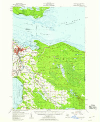
 1954 Sault Sainte Marie1979 Print · USGSThe Eastern Upper Peninsula and Ontario borderlands are captured here at the height of the mid-century era. Family historians can trace settlements like Grand Marais and Stalwart, while mapping the strategic grounds of Kincheloe AFB.3 unique versions available
 - 1955 Map of Cheboygan, 1964 Print
 1955 Cheboygan1964 Print · USGSNorthern Michigan in the mid-fifties is a landscape of dense timber and deep water, showing the region just as the road network began to modernize. Trace family roots in lakeside towns like St Ignace and Petoskey, or follow the historic tracks of the Pennsylvania RR and New York Central RR.5 unique versions available
 - 1956 Map of Sault Sainte Marie, 1964 Print
 1956 Sault Sainte Marie1964 Print · USGSThe Eastern Upper Peninsula and the Canadian border meet in this mid-sixties survey of the bustling Soo Locks region. Genealogists and historians can trace the paths of the Soo Line and locate lakeside communities from Grand Marais to Shelldrake.2 unique versions available
 - 1957 Map of Sault Sainte Marie
 1957 Sault Sainte Marie1957 Print · USGSThe Upper Peninsula and Ontario border come alive in this mid-century portrait of the eastern Lake Superior shoreline and the vital St. Marys River corridor. Genealogists and historians can trace rail-era settlements from Newberry to Detour, while locating military landmarks like Kinross Air Force Base.
 - 1957 Map of Cheboygan, 1958 Print
 1957 Cheboygan1958 Print · USGSThe Straits of Mackinac meet the northern Michigan timberlands in the late fifties, showing a landscape defined by Great Lakes shipping and inland rail. Researchers can locate many local landmarks, from Cheboygan harbor to rural sites like School No 2 and Pine Hill Cem.3 unique versions available
 - 1957 Map of Mullett Lake, 1959 Print
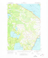 1957 Mullett Lake1959 Print · USGSThe tip of Michigan's Lower Peninsula is defined by its massive inland waters and coastal reaches along the Straits in the late fifties. Genealogists and researchers can locate several rural schools and parish churches like Sacred Heart Ch and Hebron Cem.2 unique versions available
 - 1958 Map of Cheboygan
 1958 Cheboygan1958 Print · USGSThe tip of Michigan's Lower Peninsula and the surrounding Great Lakes islands are shown here in the late fifties, during the peak of the rail-and-ferry era. Trace the paths of the Pennsylvania RR and explore lakeside settlements like St James, Petoskey, and Indian River.2 unique versions available
 - 1958 Map of Sault Sainte Marie
 1958 Sault Sainte Marie1958 Print · USGSThe eastern Upper Peninsula and the Canadian borderland appear here during the late fifties, a time of military growth and forest management. Researchers can locate vanished rail stops along the Soo Line, early sites like the Fiborn Quarry, and the sprawling Kinross Air Force Base.
End of results
Showing maps 1-12 of 12
Top cities of Mackinac County
Frequently asked questions
- What are the different types of historical maps available for Mackinac County?
- What is the oldest map of Mackinac County?
- Where can I purchase historical maps of Mackinac County for my home or office?
- Where can I download high-res historical maps of Mackinac County?
- Are there historical topographic maps available for Mackinac County?
- Is there historical aerial imagery available for Mackinac County?
- Where are historical maps of Mackinac County sourced from?