1960s Maps of Bois Blanc Township, Michigan
Explore 2 historic maps of Bois Blanc Township from the 1960s. These maps offer a rare glimpse into what life looked like during the 1960s — showing old roads, neighborhoods, homes, and landmarks that have changed or disappeared over time.
Whether you're researching your family's past, planning a metal detecting trip, or studying how Bois Blanc Township's landscape evolved across the 1960s, these high-resolution maps are a powerful tool for exploring the history of this region.
- Focus on a specific era: All maps on this page are from the 1960s, giving you a focused view of this time period.
- See what’s changed: Compare century-old streets, trails, and buildings to today's modern landscape using overlays and satellite layers.
- Research with precision: Use these maps for genealogy, historical research, land use analysis, or educational projects.
- View, download, or print: Maps are fully viewable online in high resolution, and can be downloaded or printed for your own records.
Start exploring Bois Blanc Township's history through authentic maps from the 1960s. This is your window into the past.
Bois Blanc Township, MI maps
(2)- 1964 Map of Round Island, 1966 Print
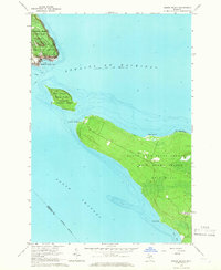 1964 Round Island1966 Print · USGSThe mid-1960s Straits of Mackinac come alive in this survey, showcasing the unique island geography and historical landmarks of northern Michigan. Researchers can trace the layout of Fort Mackinac, explore the bounds of Mackinac Island State Park, and locate coastal features like Zela Point and Round Island.2 unique versions available
 - 1964 Map of McRae Bay, 1966 Print
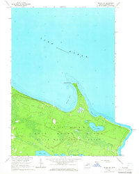 1964 McRae Bay1966 Print · USGSBois Blanc Island in the mid-1960s shows a remote landscape of state forest and secluded Great Lakes shoreline. Researchers can trace early landmarks like the McRae Cem and Lighthouse Point or locate the old Bois Blanc Landing Field.2 unique versions available
End of results
Showing maps 1-2 of 2
Top cities near Bois Blanc Township
Top neighborhoods of Bois Blanc Township
Frequently asked questions
- What are the different types of historical maps available for Bois Blanc Township?
- What is the oldest map of Bois Blanc Township?
- Where can I purchase historical maps of Bois Blanc Township for my home or office?
- Where can I download high-res historical maps of Bois Blanc Township?
- Are there historical topographic maps available for Bois Blanc Township?
- Is there historical aerial imagery available for Bois Blanc Township?
- Where are historical maps of Bois Blanc Township sourced from?