
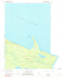
1964 Map of McRae Bay
USGS Topo · Published 1966About this map
Bois Blanc Island is revealed in detail during the mid-1960s, showing a landscape defined by its position in Lake Huron and the extensive coverage of the Black Lake State Forest. The interior of the island is dotted with numerous small bodies of water, including Lake Mary, Evans Lake, and Lost Lake, suggesting a low-lying and moisture-rich environment. Human presence is clustered near the shorelines and specific clearings, with the Bois Blanc Landing Field and a series of unimproved roads providing the primary access to the island's timber and natural resources. Notable landmarks like Lighthouse Point and the McRae Cem offer specific points of interest for genealogists and local historians tracking early maritime and settlement history. The presence of a Gravel Pit and the designated state forest lands reflect the island's reliance on natural resource management and local infrastructure maintenance during this era.
Find a feature on this map
20 named features on this map. Tap any name to fly to it.
Don’t see what you’re looking for? This feature index may not catch every label — zoom into the map to look around manually.
Map Details
Editions of this 1964 McRae Bay Map
2 editions found
Other maps of this area

1932 · St Ignace NE
USGS Topo · 1:31,680

1955 · Cheboygan
USGS Topo · 1:250,000

1957 · Cheboygan
USGS Topo · 1:62,500

1957 · Mullett Lake
USGS Topo · 1:62,500

1958 · Cheboygan
USGS Topo · 1:250,000

1964 · Round Island
USGS Topo · 1:24,000
1964 · Goose Island
USGS Topo · 1:24,000
1964 · St. Martin Island
USGS Topo · 1:24,000
1964 · Cedarville
USGS Topo · 1:24,000

1982 · Cordwood Point
USGS Topo · 1:25,000