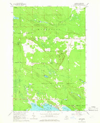
1960s Maps of Marquette Township, Michigan
Explore 5 historic maps of Marquette Township from the 1960s. These maps offer a rare glimpse into what life looked like during the 1960s — showing old roads, neighborhoods, homes, and landmarks that have changed or disappeared over time.
Whether you're researching your family's past, planning a metal detecting trip, or studying how Marquette Township's landscape evolved across the 1960s, these high-resolution maps are a powerful tool for exploring the history of this region.
- Focus on a specific era: All maps on this page are from the 1960s, giving you a focused view of this time period.
- See what’s changed: Compare century-old streets, trails, and buildings to today's modern landscape using overlays and satellite layers.
- Research with precision: Use these maps for genealogy, historical research, land use analysis, or educational projects.
- View, download, or print: Maps are fully viewable online in high resolution, and can be downloaded or printed for your own records.
Start exploring Marquette Township's history through authentic maps from the 1960s. This is your window into the past.
Marquette Township, MI maps
(5)- 1964 Map of Pickford SE, 1966 Print
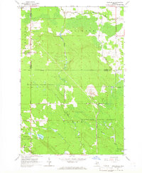 1964 Pickford SE1966 Print · USGSUpper Peninsula timber and quarrying operations are detailed in this mid-sixties survey of the Mackinac County interior. Genealogists and researchers can locate family sites at Cedarville, the Bethel Ch, and the isolated Hannah Cem along the Industrial Railroad.2 unique versions available
 - 1964 Map of Pontchartrain Shores, 1966 Print
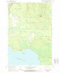 1964 Pontchartrain Shores1966 Print · USGSMackinac County's shoreline and timberlands are captured here in the mid-1960s, showing the intersection of the national forest and Lake Huron's coast. Researchers can locate the Simmons Cem, the Indian Village Cem, and the Daggett Lookout Tower among the pine barrens.2 unique versions available
 - 1964 Map of Goose Island, 1966 Print
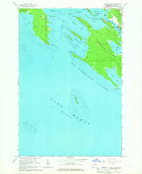 1964 Goose Island1966 Print · USGSThe Les Cheneaux archipelago comes alive in this mid-century survey of the Michigan coastline near Hessel. Researchers can trace waterfront property near Patrick Landing, locate Edgewood Cem, or explore the many inlets of Marquette Island.2 unique versions available
 - 1964 Map of St. Martin Island, 1966 Print
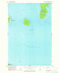 1964 St. Martin Island1966 Print · USGSLake Huron’s northern waters and the islands of Mackinac County are captured here in the mid-sixties. Researchers can trace landforms like St Martin Island, locate the Indian Burial Ground on the big island, and see early forest boundaries in the Hiawatha National Forest.2 unique versions available
 - 1964 Map of Hessel, 1966 Print
 1964 Hessel1966 Print · USGSUpper Peninsula shoreline life and forest management meet in this mid-sixties survey of Mackinac County. Researchers can trace family history through Italian Hill Cemetery, find the old Hessel Landing Field, and locate small settlements like Fenlons.2 unique versions available
End of results
Showing maps 1-5 of 5
Top cities near Marquette Township
- Pickford historical maps
- Saint Ignace historical maps
- Cedarville historical maps
- Rudyard historical maps
- Mackinac Island historical maps
Top neighborhoods of Marquette Township
Frequently asked questions
- What are the different types of historical maps available for Marquette Township?
- What is the oldest map of Marquette Township?
- Where can I purchase historical maps of Marquette Township for my home or office?
- Where can I download high-res historical maps of Marquette Township?
- Are there historical topographic maps available for Marquette Township?
- Is there historical aerial imagery available for Marquette Township?
- Where are historical maps of Marquette Township sourced from?