Old Maps of Lenox Township, Michigan for Genealogy
Trace your family roots with 46 historic maps of Lenox Township. These high-res maps reveal old neighborhoods, homesites, landmarks, and streets — helping you uncover where your ancestors lived and how the area evolved over time.
- Explore historic neighborhoods: Identify where your relatives may have lived in the 1800s or 1900s.
- Compare maps over time: Trace the changes in streets, buildings, and landmarks for multi-generational research.
- Perfect for genealogy & ancestry research: Used by family historians and researchers to map out lineage and migration.
These maps are an incredible resource for exploring your personal connection to Lenox Township's past.
Lenox Township, MI maps
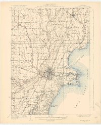
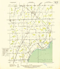
(46)- 1912 Map of Mt Clemens
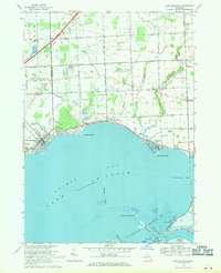
 1912 Mt Clemens1912 Print · USGSMacomb County at the dawn of the aviation age shows a landscape shaped by the winding Clinton River and the arrival of Selfridge Aviation Field. Genealogists and historians can locate legacy settlements like Waldenburg and early industrial sites like the Macomb Sugar Factory.
 - 1914 Map of Armada
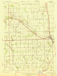
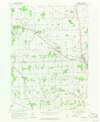
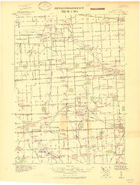 1914 Armada1914 Print · USGSMacomb and St. Clair Counties are seen here in the years before the Great War as a productive agricultural landscape tied together by rail. Researchers can trace historic farmstead locations and early rural infrastructure, from Wolcotts Mill Pond to the busy Grand Trunk R. R. junctions at Armada and Richmond.
 - 1914 Map of Algonac
 1914 Algonac1914 Print · USGSThe St. Clair River delta and Harsens Island are captured here before the mid-century shoreline changes. Genealogists can locate family holdings near Starrville or trace the early waterfront developments of Sans Souci P.O. and Tashmoo Park.
 - 1928 Map of Armada
 1928 Armada1928 Print · USGSMacomb and St. Clair counties are shown here in the early twentieth century as agriculture and rail travel dominated the landscape. Genealogists can trace family roots through specific locales like Doyle P.O., Sullicks Corners, and the mill at Wolcots Mill Pond.
 - 1928 Map of Hicky
 1928 Hicky1928 Print · USGSSt. Clair County's rural townships and railway hubs are captured here in the years following the Great War. Researchers can locate vanished landmarks and post offices like Lambs P.O. or trace the early paths of the Fort Gratiot Turnpike and Grand Trunk R. R.
 - 1929 Map of Mt Clemens
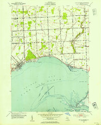
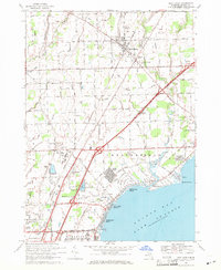
 1929 Mt Clemens1929 Print · USGSMacomb County at the end of the twenties shows a landscape of growing towns and early aviation history along the Lake Saint Clair shoreline. Genealogists and historians can trace local landmarks like Selfridge Field, the Grand Trunk Railroad, and numerous parish schools from Fraser to New Haven.4 unique versions available
 - 1936 Map of New Haven
 1936 New Haven1936 Print · USGSCoastal Macomb County and the shores of Lake St Clair are captured here during the mid-1930s, showing a landscape defined by drainage districts and rail transport. Researchers can locate vanished landmarks like Chesterfield Sta, rural schoolhouses such as Bates Sch, and the Grand Trunk railroad line.
 - 1936 Map of New Baltimore
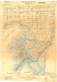
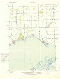 1936 New Baltimore1936 Print · USGSAnchor Bay and the coastal settlements of Macomb and St. Clair Counties come alive in the mid-1930s just as aerial mapping was perfecting local detail. Genealogists and historians can trace family locations near New Baltimore, St Pauls Ch, and rural schools like Poplar Grove Sch.
 - 1939 Map of New Baltimore
 1939 New Baltimore1939 Print · USGSThe Lake St. Clair shoreline at the end of the thirties was a region of marshy deltas and small lakefront villages. You can trace early parish roots and rural life at Sacred Heart Cem, Big Stone Sch, and the unique waterways around Dickinson Island.
 - 1939 Map of Adair
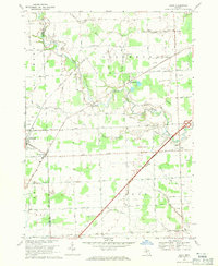
 1939 Adair1939 Print · USGSSt. Clair County in the late 1930s shows a landscape of established farmsteads and a remarkably high density of rural schools and churches. Genealogists can trace family footprints through sites like Pink Sch, Columbus Cem, and the village of Adair.
 - 1945 Map of Richmond
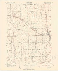
 1945 Richmond1945 Print · USGSDuring the mid-1940s, Macomb County was a landscape of rail-connected towns and rural townships. Trace family roots through local anchors like Bates Cem, the Zion Ch, and numerous schoolhouses including Hunt Sch and Richards Sch.2 unique versions available
 - 1952 Map of Adair, 1954 Print
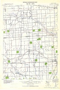
 1952 Adair1954 Print · USGSEastern Michigan’s rural townships are captured here in the early fifties, showing the transition from traditional farming communities to a modernizing road network. Genealogists can locate family landmarks like Columbus Cem, Pink Sch, and the community of Adair.2 unique versions available
 - 1952 Map of New Baltimore, 1954 Print
 1952 New Baltimore1954 Print · USGSThe Macomb and St. Clair County shoreline comes alive in this mid-century survey of the Anchor Bay waterfront. Researchers can trace family roots through numerous local landmarks, including Fair Haven Sch, St Marys Cem, and the old settlement of Peters.2 unique versions available
 - 1952 Map of New Haven, 1954 Print
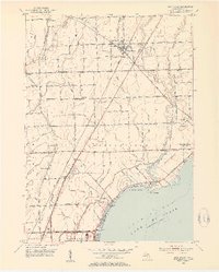 1952 New Haven1954 Print · USGSMacomb County's shoreline and rural interior are captured here in the early fifties, from the bustling rail corridor at New Haven to the Anchor Bay coast. Genealogists and local historians can locate several family-named landmarks and institutions, including Harris Sch, Hart Cem, and the Selfridge Air Force Base.2 unique versions available
 - 1952 Map of Richmond, 1954 Print
 1952 Richmond1954 Print · USGSThe rural borderlands of Macomb and St. Clair counties come to life in the early fifties, showing a landscape of specialized drainage and local school districts. Genealogists can trace family roots at Richmond Cem or find vanished landmarks like the Clay Road Sch and Howe Sch.2 unique versions available
 - 1952 Map of Mt Clemens, 1959 Print
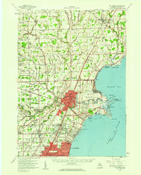 1952 Mt Clemens1959 Print · USGSIn the early fifties, Macomb County saw rapid suburban growth around the massive Selfridge Air Force Base and Lake St. Clair. Genealogists can trace early neighborhood roots and family landmarks like McKinley Airport, Moravian Sch, and St Paul Cem.
 - 1954 Map of Detroit
 1954 Detroit1954 Print · USGSThe Detroit metro and its Ontario neighbors are shown at the height of the mid-century industrial era, just as the suburbs were rapidly expanding. Researchers can trace the massive rail networks of the Wabash Railroad or locate landmarks like Grosse Ile and Selfridge Air Force Base.
 - 1961 Map of Detroit, 1973 Print
 1961 Detroit1973 Print · USGSThe international border between Michigan and Ontario was a bustling industrial corridor in the early sixties. Researchers can trace the transit networks and riverfront infrastructure connecting Detroit to Windsor via the Detroit-Windsor Tunnel and major air hubs like Willow Run Airport.2 unique versions available
 - 1965 Map of Detroit
 1965 Detroit1965 Print · USGSThe industrial corridor between Michigan and Ontario is captured here at mid-century, showing the dense rail and river networks of the Great Lakes. Local historians can trace the paths of the Grand Trunk Western RR and locate key landmarks like Selfridge Air Force Base and Grosse Ile.
 - 1968 Map of New Baltimore, 1971 Print
 1968 New Baltimore1971 Print · USGSNorthern Lake St. Clair coastal life is captured here in the late sixties as residential expansion meets industrial utility. Genealogists and local historians can locate Sacred Heart Cem, the Motor City Drag Strip, and Fair Haven Sch.2 unique versions available
 - 1968 Map of New Haven, 1971 Print
 1968 New Haven1971 Print · USGSNorthern Macomb County is shown in the late sixties as the shoreline of Lake St Clair fills with suburban developments. Genealogists can locate family landmarks like Hart Cem, Fairchild Chapel, and the Lenox Gas Storage Field.3 unique versions available
 - 1968 Map of Richmond, 1971 Print
 1968 Richmond1971 Print · USGSMacomb County agriculture and rail life thrive in the late sixties between the hubs of Armada and Richmond. Genealogists can trace family roots at Bates Cem and St Mary Ch, while historians can follow the Grand Trunk Western line.2 unique versions available
 - 1968 Map of Adair, 1971 Print
 1968 Adair1971 Print · USGSThe rural landscapes of St. Clair and Macomb counties come alive in this late-sixties study of the area between the Belle and Puttygut rivers. Genealogists can trace family footprints through numerous cemeteries like Kittridge Cem and vanished landmarks in Muttonville and Snyderville.3 unique versions available
 - 1981 Map of Lake St. Clair North
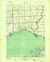
 1981 Lake St. Clair North1981 Print · USGSThe Michigan-Ontario borderlands come alive in the early eighties, showcasing the busy international corridor from the St Clair River down to the delta. Trace the intricate channels around Harsens Island or locate regional hubs like Selfridge Air Force Base and Sarnia.
 - 1991 Map of Adair
 1991 Adair1991 Print · USGSAgricultural life meets the energy industry in St. Clair County during the early nineties, where river valleys are dotted with old family-named drains and oil fields. Genealogists can locate legacy sites like St Michaels Cem, St Peter Sch, and the quiet crossroads of Snyderville.
Showing maps 1-25 of 46
Top cities near Lenox Township
- Sterling Heights historical maps
- Clinton Township historical maps
- Macomb Township historical maps
- Shelby Charter Township historical maps
- Saint Clair Shores historical maps
- Roseville historical maps
See more
Top neighborhoods of Lenox Township
Frequently asked questions
- What are the different types of historical maps available for Lenox Township?
- What is the oldest map of Lenox Township?
- Where can I purchase historical maps of Lenox Township for my home or office?
- Where can I download high-res historical maps of Lenox Township?
- Are there historical topographic maps available for Lenox Township?
- Is there historical aerial imagery available for Lenox Township?
- Where are historical maps of Lenox Township sourced from?