1930s Maps of Mount Clemens, Michigan
Explore 2 historic maps of Mount Clemens from the 1930s. These maps offer a rare glimpse into what life looked like during the 1930s — showing old roads, neighborhoods, homes, and landmarks that have changed or disappeared over time.
Whether you're researching your family's past, planning a metal detecting trip, or studying how Mount Clemens's landscape evolved across the 1930s, these high-resolution maps are a powerful tool for exploring the history of this region.
- Focus on a specific era: All maps on this page are from the 1930s, giving you a focused view of this time period.
- See what’s changed: Compare century-old streets, trails, and buildings to today's modern landscape using overlays and satellite layers.
- Research with precision: Use these maps for genealogy, historical research, land use analysis, or educational projects.
- View, download, or print: Maps are fully viewable online in high resolution, and can be downloaded or printed for your own records.
Start exploring Mount Clemens's history through authentic maps from the 1930s. This is your window into the past.
Mount Clemens, MI maps
(2)- 1936 Map of Selfridge Field
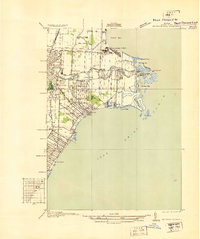 1936 Selfridge Field1936 Print · USGSThe Macomb County shoreline and the early aviation footprint of Selfridge Field are preserved here during the mid-1930s. Researchers can trace the riverfront growth of Lakeside and find local landmarks like School No 3 and Point Rosa.
 - 1936 Map of Mt Clemens
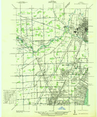 1936 Mt Clemens1936 Print · USGSMacomb County is captured here in the mid-1930s, showing the early suburban development radiating from Mt Clemens along the Clinton River. Researchers can trace old family burial grounds like Sterling Grove Cem and local schoolhouses including Nicke Sch and Garfield Sch.
End of results
Showing maps 1-2 of 2
Top cities near Mount Clemens
- Detroit historical maps
- Sterling Heights historical maps
- Warren historical maps
- Clinton Township historical maps
- Macomb Township historical maps
- Troy historical maps
See more
Top neighborhoods of Mount Clemens
- Canfield Manor historical maps
- Olsen - Southriver historical maps
- Martin Luther King historical maps
- Mount Clemens Downtown Loop historical maps
- Breitmeyer Hills historical maps
- Seminole Hills historical maps
Frequently asked questions
- What are the different types of historical maps available for Mount Clemens?
- What is the oldest map of Mount Clemens?
- Where can I purchase historical maps of Mount Clemens for my home or office?
- Where can I download high-res historical maps of Mount Clemens?
- Are there historical topographic maps available for Mount Clemens?
- Is there historical aerial imagery available for Mount Clemens?
- Where are historical maps of Mount Clemens sourced from?