1960s Maps of Sterling Heights, Michigan
Explore 6 historic maps of Sterling Heights from the 1960s. These maps offer a rare glimpse into what life looked like during the 1960s — showing old roads, neighborhoods, homes, and landmarks that have changed or disappeared over time.
Whether you're researching your family's past, planning a metal detecting trip, or studying how Sterling Heights's landscape evolved across the 1960s, these high-resolution maps are a powerful tool for exploring the history of this region.
- Focus on a specific era: All maps on this page are from the 1960s, giving you a focused view of this time period.
- See what’s changed: Compare century-old streets, trails, and buildings to today's modern landscape using overlays and satellite layers.
- Research with precision: Use these maps for genealogy, historical research, land use analysis, or educational projects.
- View, download, or print: Maps are fully viewable online in high resolution, and can be downloaded or printed for your own records.
Start exploring Sterling Heights's history through authentic maps from the 1960s. This is your window into the past.
Sterling Heights, MI maps
(6)- 1961 Map of Detroit, 1973 Print
 1961 Detroit1973 Print · USGSThe international border between Michigan and Ontario was a bustling industrial corridor in the early sixties. Researchers can trace the transit networks and riverfront infrastructure connecting Detroit to Windsor via the Detroit-Windsor Tunnel and major air hubs like Willow Run Airport.2 unique versions available
 - 1965 Map of Detroit
 1965 Detroit1965 Print · USGSThe industrial corridor between Michigan and Ontario is captured here at mid-century, showing the dense rail and river networks of the Great Lakes. Local historians can trace the paths of the Grand Trunk Western RR and locate key landmarks like Selfridge Air Force Base and Grosse Ile.
 - 1968 Map of Waldenburg, 1970 Print
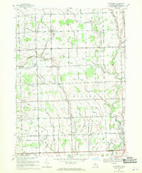 1968 Waldenburg1970 Print · USGSMacomb County is captured in the late sixties as its traditional farming roots met growing suburban interest and private aviation. Genealogists can trace family landmarks like the Macomb Center Cem or local school sites including St Peters Sch and St Isidores Sch.3 unique versions available
 - 1968 Map of Utica, 1970 Print
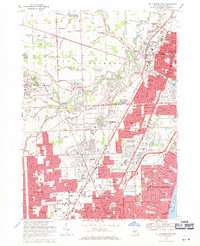
 1968 Utica1970 Print · USGSThe Macomb and Oakland county line comes alive in the late sixties, showing the suburban growth surrounding Rochester and Utica. Genealogists can trace family roots through numerous sites like Stony Creek Cem, Disco, and Washington.4 unique versions available
 - 1968 Map of Warren, 1971 Print
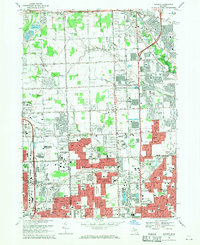 1968 Warren1971 Print · USGSThe Detroit suburbs were in the midst of a massive postwar boom when this survey was conducted. Genealogists and local historians can trace dozens of neighborhood schools and churches, from Holy Trinity Cem to the early days of the Oakland Mall Shopping Center.5 unique versions available
 - 1968 Map of Mt Clemens West, 1971 Print
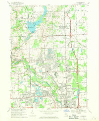
 1968 Mt Clemens West1971 Print · USGSMacomb County enters a period of significant suburban expansion in the late sixties as residential neighborhoods fill the space between historical townships. Researchers can trace the development of Sterling Heights and Roseville through landmarks like Resurrection Cemetery and the Mc Kinley Airport.4 unique versions available
End of results
Showing maps 1-6 of 6
Top cities near Sterling Heights
- Detroit historical maps
- Warren historical maps
- Clinton Township historical maps
- Macomb Township historical maps
- Troy historical maps
- Shelby Charter Township historical maps
See more
Frequently asked questions
- What are the different types of historical maps available for Sterling Heights?
- What is the oldest map of Sterling Heights?
- Where can I purchase historical maps of Sterling Heights for my home or office?
- Where can I download high-res historical maps of Sterling Heights?
- Are there historical topographic maps available for Sterling Heights?
- Is there historical aerial imagery available for Sterling Heights?
- Where are historical maps of Sterling Heights sourced from?