1970s Maps of Norman Township, Michigan
Explore 3 historic maps of Norman Township from the 1970s. These maps offer a rare glimpse into what life looked like during the 1970s — showing old roads, neighborhoods, homes, and landmarks that have changed or disappeared over time.
Whether you're researching your family's past, planning a metal detecting trip, or studying how Norman Township's landscape evolved across the 1970s, these high-resolution maps are a powerful tool for exploring the history of this region.
- Focus on a specific era: All maps on this page are from the 1970s, giving you a focused view of this time period.
- See what’s changed: Compare century-old streets, trails, and buildings to today's modern landscape using overlays and satellite layers.
- Research with precision: Use these maps for genealogy, historical research, land use analysis, or educational projects.
- View, download, or print: Maps are fully viewable online in high resolution, and can be downloaded or printed for your own records.
Start exploring Norman Township's history through authentic maps from the 1970s. This is your window into the past.
Norman Township, MI maps
(3)- 1976 Map of Onekama SE
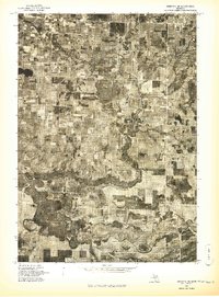 1976 Onekama SE1976 Print · USGSManistee County in the mid-1970s is captured here through detailed aerial imagery, showing the rural landscape and river system. Genealogists and local historians can trace the early footprints of Kaleva, Brethren, and the small settlement at Chief Lake.
 - 1976 Map of Wellston NE
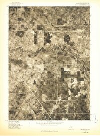 1976 Wellston NE1976 Print · USGSNorthern Michigan's rural landscape is captured during the mid-seventies in this detailed orthophoto study. Researchers can trace the winding course of the Pine River and examine the specific patterns of forest and field clearings across the county.
 - 1976 Map of Wellston NW
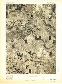 1976 Wellston NW1976 Print · USGSThe Manistee County forest lands and rural settlements come into focus during the mid-seventies in this detailed orthophoto. Local historians can trace the clearings around Wellston and Dublin, or study the wooded banks along Tippy Dam Pond.
End of results
Showing maps 1-3 of 3
Top cities near Norman Township
- Kaleva historical maps
- Mesick historical maps
- Peacock historical maps
- Brethren historical maps
- Marilla historical maps
- Sauble historical maps
See more
Top neighborhoods of Norman Township
Frequently asked questions
- What are the different types of historical maps available for Norman Township?
- What is the oldest map of Norman Township?
- Where can I purchase historical maps of Norman Township for my home or office?
- Where can I download high-res historical maps of Norman Township?
- Are there historical topographic maps available for Norman Township?
- Is there historical aerial imagery available for Norman Township?
- Where are historical maps of Norman Township sourced from?