1950s Maps of Champion Township, Michigan
Explore 8 historic maps of Champion Township from the 1950s. These maps offer a rare glimpse into what life looked like during the 1950s — showing old roads, neighborhoods, homes, and landmarks that have changed or disappeared over time.
Whether you're researching your family's past, planning a metal detecting trip, or studying how Champion Township's landscape evolved across the 1950s, these high-resolution maps are a powerful tool for exploring the history of this region.
- Focus on a specific era: All maps on this page are from the 1950s, giving you a focused view of this time period.
- See what’s changed: Compare century-old streets, trails, and buildings to today's modern landscape using overlays and satellite layers.
- Research with precision: Use these maps for genealogy, historical research, land use analysis, or educational projects.
- View, download, or print: Maps are fully viewable online in high resolution, and can be downloaded or printed for your own records.
Start exploring Champion Township's history through authentic maps from the 1950s. This is your window into the past.
Champion Township, MI maps
(8)- 1954 Map of Negaunee SW, 1955 Print
 1954 Negaunee SW1955 Print · USGSThe iron-rich hills of the Marquette Range are shown in the mid-fifties, when mining and rail operations defined local life. Trace the industrial footprint of Morris Mine and Lloyd Mine alongside the sprawling waters of the Dead River Storage Basin.4 unique versions available
 - 1954 Map of Negaunee, 1955 Print
 1954 Negaunee1955 Print · USGSIron mining and hydroelectric power define the Marquette Range in the mid-fifties. Genealogists and industrial historians can trace the workings of the Mather Mine A, the Eagle Mills settlement, and the Morgan Heights Sanatorium.3 unique versions available
 - 1954 Map of Huron Mountain, 1956 Print
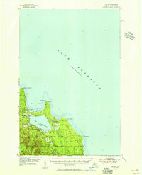
 1954 Huron Mountain1956 Print · USGSThe Lake Superior coast and the interior peaks of the Huron Mountains are captured here in the mid-1950s. Trace the remote northern shoreline from the Lighthouse on Lighthouse Island to the secluded waters of Ives Lake and Gillet Landing.3 unique versions available
 - 1954 Map of Big Bay, 1956 Print
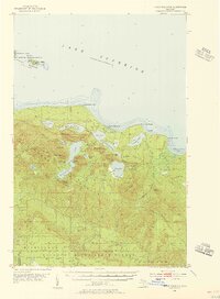
 1954 Big Bay1956 Print · USGSBig Bay and the Marquette County shoreline are documented here in the mid-1950s as a mix of remote state forest and coastal settlement. Genealogists and local historians can trace the community around Big Bay and Lake Independence, finding landmarks like the lighthouse and Alder Cem.3 unique versions available
 - 1955 Map of Champion, 1956 Print
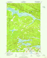
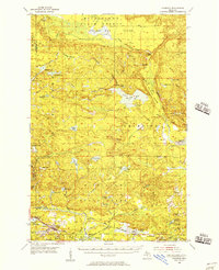
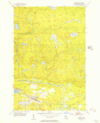 1955 Champion1956 Print · USGSThe northern Michigan landscape near Marquette is captured in the mid-fifties, showing a region defined by dense forests and the iron-hauling railroads. Trace the routes of the Chicago and North Western and locate local sites like Sacred Heart Cem or the settlement of Beacon.3 unique versions available
 - 1955 Map of Diorite, 1956 Print
 1955 Diorite1956 Print · USGSIron mining and forestry dominate this Marquette County landscape in the mid-fifties. Researchers can locate specific industrial sites like the American Mine, the settlement at Diorite, and the tracks of the Chicago and North Western railroad.3 unique versions available
 - 1955 Map of Champion, 1957 Print
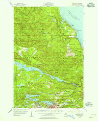
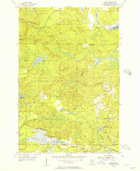
 1955 Champion1957 Print · USGSUpper Peninsula mining and timber culture are in full view in the mid-fifties, centered on the railroad corridor between Baraga and Marquette. Researchers can trace the rail-served settlements of Champion and Beacon or locate industrial sites like the Silver Lead Mine and Dexter Mine.4 unique versions available
 - 1958 Map of Marquette, 1968 Print
 1958 Marquette1968 Print · USGSThe Upper Peninsula’s central corridor is captured here in the mid-twentieth century as mining and timber industries thrived alongside new military installations. Genealogists and historians can trace the rail lines of the Soo Line Railroad through settlements like Gwinn, Turin, and Chatham.2 unique versions available
End of results
Showing maps 1-8 of 8
Top cities near Champion Township
- Ishpeming historical maps
- Negaunee historical maps
- Humboldt historical maps
- Champion historical maps
- Big Bay historical maps
Top neighborhoods of Champion Township
Frequently asked questions
- What are the different types of historical maps available for Champion Township?
- What is the oldest map of Champion Township?
- Where can I purchase historical maps of Champion Township for my home or office?
- Where can I download high-res historical maps of Champion Township?
- Are there historical topographic maps available for Champion Township?
- Is there historical aerial imagery available for Champion Township?
- Where are historical maps of Champion Township sourced from?