1950s Maps of Gillet Landing, Powell Township
Explore 2 historic maps of Gillet Landing from the 1950s. These maps offer a rare glimpse into what life looked like during the 1950s — showing old roads, neighborhoods, homes, and landmarks that have changed or disappeared over time.
Whether you're researching your family's past, planning a metal detecting trip, or studying how Gillet Landing's landscape evolved across the 1950s, these high-resolution maps are a powerful tool for exploring the history of this region.
- Focus on a specific era: All maps on this page are from the 1950s, giving you a focused view of this time period.
- See what’s changed: Compare century-old streets, trails, and buildings to today's modern landscape using overlays and satellite layers.
- Research with precision: Use these maps for genealogy, historical research, land use analysis, or educational projects.
- View, download, or print: Maps are fully viewable online in high resolution, and can be downloaded or printed for your own records.
Start exploring Gillet Landing's history through authentic maps from the 1950s. This is your window into the past.
Gillet Landing, Powell Township maps
(2)- 1954 Map of Huron Mountain, 1956 Print
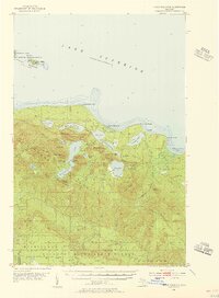 1954 Huron Mountain1956 Print · USGSThe Lake Superior coast and the interior peaks of the Huron Mountains are captured here in the mid-1950s. Trace the remote northern shoreline from the Lighthouse on Lighthouse Island to the secluded waters of Ives Lake and Gillet Landing.3 unique versions available
 - 1958 Map of Marquette, 1968 Print
 1958 Marquette1968 Print · USGSThe Upper Peninsula’s central corridor is captured here in the mid-twentieth century as mining and timber industries thrived alongside new military installations. Genealogists and historians can trace the rail lines of the Soo Line Railroad through settlements like Gwinn, Turin, and Chatham.2 unique versions available
End of results
Showing maps 1-2 of 2
Top cities near Gillet Landing
Frequently asked questions
- What are the different types of historical maps available for Gillet Landing?
- What is the oldest map of Gillet Landing?
- Where can I purchase historical maps of Gillet Landing for my home or office?
- Where can I download high-res historical maps of Gillet Landing?
- Are there historical topographic maps available for Gillet Landing?
- Is there historical aerial imagery available for Gillet Landing?
- Where are historical maps of Gillet Landing sourced from?