1900s (20th Century) Maps of Republic Township, Michigan
Explore 26 historic maps of Republic Township from the 1900s (20th Century). These maps offer a rare glimpse into what life looked like during the 1900s — showing old roads, neighborhoods, homes, and landmarks that have changed or disappeared over time.
Whether you're researching your family's past, planning a metal detecting trip, or studying how Republic Township's landscape evolved across the 1900s, these high-resolution maps are a powerful tool for exploring the history of this region.
- Focus on a specific era: All maps on this page are from the 1900s, giving you a focused view of this time period.
- See what’s changed: Compare century-old streets, trails, and buildings to today's modern landscape using overlays and satellite layers.
- Research with precision: Use these maps for genealogy, historical research, land use analysis, or educational projects.
- View, download, or print: Maps are fully viewable online in high resolution, and can be downloaded or printed for your own records.
Start exploring Republic Township's history through authentic maps from the 1900s. This is your window into the past.
Republic Township, MI maps
(26)- 1955 Map of Champion, 1956 Print
 1955 Champion1956 Print · USGSThe northern Michigan landscape near Marquette is captured in the mid-fifties, showing a region defined by dense forests and the iron-hauling railroads. Trace the routes of the Chicago and North Western and locate local sites like Sacred Heart Cem or the settlement of Beacon.3 unique versions available
 - 1955 Map of Witch Lake, 1956 Print
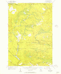
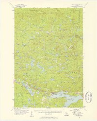
 1955 Witch Lake1956 Print · USGSThe Upper Peninsula wilderness of the mid-fifties is captured here along the Iron and Marquette county line. Genealogists and collectors can trace the rail sidings at Witbeck and explore dozens of named waters like Fence Lake and Sundog Lake.3 unique versions available
 - 1955 Map of Ralph NW, 1956 Print
 1955 Ralph NW1956 Print · USGSUpper Peninsula timberlands and river valleys are captured here in the mid-fifties at the Marquette and Dickinson county line. Trace the route of the Escanaba and Lake Superior railroad through the Sturgeon River State Forest and along the Ford River.3 unique versions available
 - 1955 Map of Witch Lake NE, 1956 Print
 1955 Witch Lake NE1956 Print · USGSUpper Peninsula wilderness at the edge of Marquette County is documented here during the mid-fifties. Researchers can trace the winding Michigamme River and find named landmarks like Trout Falls, Dashwa Lake, and the Iron Range State Forest.2 unique versions available
 - 1955 Map of Republic, 1957 Print
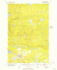
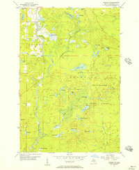
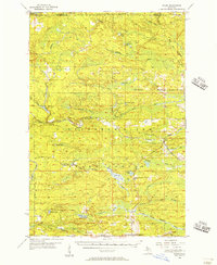
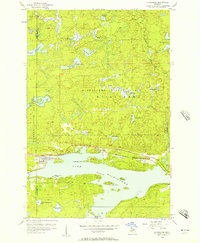
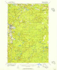 1955 Republic1957 Print · USGSThe iron mining heart of the Upper Peninsula is frozen in time during the mid-fifties, showing the heavy rail and industrial footprint in Marquette County. Researchers can trace the legacy of extractive industry through the Republic Mine, Humboldt Cemetery, and the abandoned Black River School.3 unique versions available
 - 1955 Map of Republic, 1957 Print
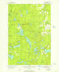
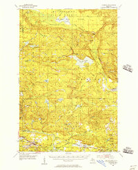
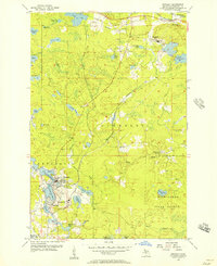 1955 Republic1957 Print · USGSMarquette County iron country is captured here in the mid-1950s, showing the height of the region's industrial rail and mining activity. Researchers can trace the massive Republic Mine site, the old Humboldt Cem, and the path of the Duluth South Shore and Atlantic railroad.2 unique versions available
 - 1955 Map of Witch Lake, 1957 Print
 1955 Witch Lake1957 Print · USGSThe Upper Peninsula timber and rail landscape is captured here in the mid-fifties, showing the intersection of Marquette, Baraga, and Iron counties. You can trace the path of the Chicago and North Western railroad past Witbeck or locate the Lookout Tower and Nilsson Dam deep in the state forests.3 unique versions available
 - 1955 Map of Republic SW, 1957 Print
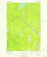
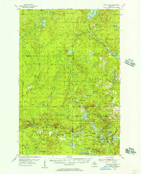
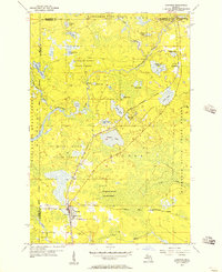
 1955 Republic SW1957 Print · USGSMarquette County's forest and water networks are captured here in the mid-fifties, showing the wild terrain between Republic and Humboldt. Trace the course of the Michigamme River past Big Lick Lake and the isolated waters of the Chain of Lakes.2 unique versions available
 - 1955 Map of Ralph, 1957 Print
 1955 Ralph1957 Print · USGSUpper Peninsula timber and rail life come into focus in the mid-1950s around the Dickinson and Marquette county line. Researchers can trace the Escanaba and Lake Superior line to local hubs like Ralph and Stafford, or locate the Ralph Cem.3 unique versions available
 - 1955 Map of Champion, 1957 Print
 1955 Champion1957 Print · USGSUpper Peninsula mining and timber culture are in full view in the mid-fifties, centered on the railroad corridor between Baraga and Marquette. Researchers can trace the rail-served settlements of Champion and Beacon or locate industrial sites like the Silver Lead Mine and Dexter Mine.4 unique versions available
 - 1955 Map of Channing, 1957 Print
 1955 Channing1957 Print · USGSUpper Peninsula timber and rail country come alive in the mid-1950s at the junction of two major rail lines. Genealogists can locate the Channing Cem and trace small settlements like Floodwood and Golden along the Michigamme River.2 unique versions available
 - 1956 Map of Michigamme, 1957 Print
 1956 Michigamme1957 Print · USGSThe Upper Peninsula's logging and mining heart comes to life in this mid-century portrait of Marquette and Baraga Counties. Traces of industrial history are everywhere, from the Ohio Mine and Railroad Grade to remote camps like Boniface Camp.4 unique versions available
 - 1956 Map of Sagola, 1957 Print
 1956 Sagola1957 Print · USGSUpper Peninsula timber and rail history converge in the mid-fifties at the junction of the Chicago and North Western Railway. Trace the footprints of logging and mining settlements at Channing, Mansfield Location, and the McMillan Camp.
 - 1956 Map of Michigamme, 1957 Print
 1956 Michigamme1957 Print · USGSMarquette and Baraga counties are shown in the mid-fifties, centered on the village of Michigamme and its namesake lake. Trace the Duluth South Shore and Atlantic railway or locate family sites near Lakeview Cem and Presbytery Point.3 unique versions available
 - 1958 Map of Marquette, 1968 Print
 1958 Marquette1968 Print · USGSThe Upper Peninsula’s central corridor is captured here in the mid-twentieth century as mining and timber industries thrived alongside new military installations. Genealogists and historians can trace the rail lines of the Soo Line Railroad through settlements like Gwinn, Turin, and Chatham.2 unique versions available
 - 1958 Map of Iron River, 1968 Print
 1958 Iron River1968 Print · USGSThe Upper Peninsula in the late fifties is captured here as a landscape of timber, iron, and rail. Genealogists and historians can trace rail stops like Mass Station or explore the coastlines of Lake Gogebic and Keweenaw Bay.3 unique versions available
 - 1960 Map of Iron River
 1960 Iron River1960 Print · USGSThe Upper Peninsula’s western reaches are shown in the late fifties, featuring the industrial infrastructure of the Copper Country and the vast Ottawa National Forest. Researchers can trace the rail lines of the Milwaukee Road through settlements like Bruce Crossing and the White Pine Mine.
 - 1960 Map of Marquette
 1960 Marquette1960 Print · USGSUpper Peninsula mining and maritime commerce reach their peak in the late fifties across the Lake Superior shoreline. Genealogists and historians can locate remote settlements like Big Bay and Dukes, while tracing the Cyr Mine and the active rail lines of the Lake Superior and Ishpeming railroad.
 - 1961 Map of Marquette
 1961 Marquette1961 Print · USGSUpper Peninsula life in the early sixties centered on the iron docks and timber stands of the Lake Superior shore. Genealogists and historians can trace rail-to-port connections via the Lake Superior and Ishpeming Railroad and locate active sites like Republic Mine or the K.I. Sawyer Air Force Base.
 - 1961 Map of Iron River
 1961 Iron River1961 Print · USGSThe Upper Peninsula and northern Wisconsin are shown here in the early 1960s, a landscape defined by the iron range and vast timberlands. Researchers can trace the legacy of mining and rail transport through Caspian, the Lac Du Flambeau Indian Reservation, and the Milwaukee Road.
 - 1967 Map of Iron River, 1968 Print
 1967 Iron River1968 Print · USGSThe Upper Peninsula and northern Wisconsin borderlands are shown here in the late sixties, a landscape of deep woods and iron-country rail lines. Genealogists and historians can trace the lakeside settlements of L'Anse and Ontonagon or follow the Soo Line through towns like Michigamme and Nestoria.
 - 1968 Map of Marquette, 1977 Print
 1968 Marquette1977 Print · USGSThe Upper Peninsula iron range and Lake Superior coastline are captured here in the late sixties. Genealogists and historians can trace the rail-to-port infrastructure and the Cold War presence of K I Sawyer Air Force Base alongside towns like Ishpeming and Munising.
 - 1983 Map of Gwinn
 1983 Gwinn1983 Print · USGSThe heart of Michigan's Marquette Iron Range is captured here during the 1980s, when mining and military operations defined the local landscape. Genealogists and industrial historians can trace the tracks of the Chicago and North Western to the National Mine or the airman's life at K I Sawyer Air Force Base.2 unique versions available
 - 1985 Map of Marquette
 1985 Marquette1985 Print · USGSThe iron mining country of Michigan's Upper Peninsula is shown here during the mid-1980s as industrial transport networks connected the interior to the coast. Researchers can trace historic rail lines like the Soo Line and Ls&I or locate local landmarks like Holy Cross Cem and Northern Michigan University.3 unique versions available
 - 1989 Map of Iron River, 1990 Print
 1989 Iron River1990 Print · USGSUpper Peninsula mining and timber lands are documented here in the late 1980s, showcasing the region's industrial and natural interface. Researchers can trace the iron heritage through the Monongahela Mine and local junctions like Kelso Junction and Amasa.
Showing maps 1-25 of 26
Top cities near Republic Township
Top neighborhoods of Republic Township
Frequently asked questions
- What are the different types of historical maps available for Republic Township?
- What is the oldest map of Republic Township?
- Where can I purchase historical maps of Republic Township for my home or office?
- Where can I download high-res historical maps of Republic Township?
- Are there historical topographic maps available for Republic Township?
- Is there historical aerial imagery available for Republic Township?
- Where are historical maps of Republic Township sourced from?