1970s Maps of Mason County, Michigan
Explore 4 historic maps of Mason County from the 1970s. These maps offer a rare glimpse into what life looked like during the 1970s — showing old roads, neighborhoods, homes, and landmarks that have changed or disappeared over time.
Whether you're researching your family's past, planning a metal detecting trip, or studying how Mason County's landscape evolved across the 1970s, these high-resolution maps are a powerful tool for exploring the history of this region.
- Focus on a specific era: All maps on this page are from the 1970s, giving you a focused view of this time period.
- See what’s changed: Compare century-old streets, trails, and buildings to today's modern landscape using overlays and satellite layers.
- Research with precision: Use these maps for genealogy, historical research, land use analysis, or educational projects.
- View, download, or print: Maps are fully viewable online in high resolution, and can be downloaded or printed for your own records.
Start exploring Mason County's history through authentic maps from the 1970s. This is your window into the past.
Mason County, MI maps
(4)- 1976 Map of Custer NE
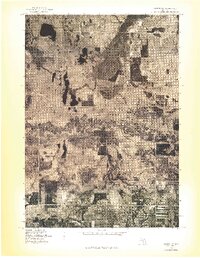 1976 Custer NE1976 Print · USGSMason County forest and farmland appear in striking aerial detail during the mid-1970s. Genealogists and local historians can trace property boundaries and river access points near Tallman, Walhalla, and the winding Pere Marquette River.
 - 1976 Map of Custer NW
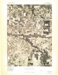 1976 Custer NW1976 Print · USGSThe Mason County countryside is captured in the mid-1970s through this aerial orthophoto, showing the rural landscape around the Custer settlement. You can trace the complex, winding path of the Pere Marquette River as it cuts through local farmsteads.
 - 1976 Map of Custer SW
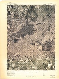 1976 Custer SW1976 Print · USGSOceana County is captured in mid-1970s aerial detail during this transitional era of rural Michigan life. Genealogists and land researchers can trace the exact buildings and farm footprints of Crystal Valley and the surrounding wooded sections.
 - 1976 Map of Custer SE
 1976 Custer SE1976 Print · USGSCovers Mason County, including Carr, Logan Township, and other nearby areas
End of results
Showing maps 1-4 of 4
Top cities of Mason County
Frequently asked questions
- What are the different types of historical maps available for Mason County?
- What is the oldest map of Mason County?
- Where can I purchase historical maps of Mason County for my home or office?
- Where can I download high-res historical maps of Mason County?
- Are there historical topographic maps available for Mason County?
- Is there historical aerial imagery available for Mason County?
- Where are historical maps of Mason County sourced from?