Old Maps of Mason County, Michigan for Hiking & Exploration
Hike through history with 127 historic maps of Mason County. Explore old trails, ghost towns, and forgotten backroads — perfect for outdoor adventurers and local explorers.
- Rediscover forgotten places: Map out old mining camps, roads, and footpaths that no longer exist on modern maps.
- Layer with modern tools: Combine with LiDAR or satellite views to plan hikes through historical terrain.
- Made for exploration: Popular among hikers, overlanders, and local history lovers.
Use these maps to find adventure and explore the hidden past of Mason County.
Mason County, MI maps
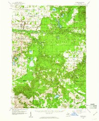
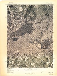
(127)- 1931 Map of Custer NW
 1931 Custer NW1931 Print · USGSMason County’s rural landscape during the early thirties is anchored by the rail-and-road junction at Custer. Genealogists and historians can trace the distribution of early twentieth-century country schools like Weldon Cr Sch and Ressigue Sch along the Pere Marquette River.
 - 1931 Map of Custer SW
 1931 Custer SW1931 Print · USGSThe borderlands of Oceana and Mason County are captured in the early 1930s when rural education and township government anchored the community. Genealogists can locate family homesteads near Crystal and trace the paths to Fern Sch, Kidder Sch, or the Town Hall.
 - 1931 Map of Custer NE
 1931 Custer NE1931 Print · USGSMason County in the early 1930s is a landscape of winding rivers and country schoolhouses. Genealogists and local historians can trace the foundations of Tallman and Walhalla, or locate landmarks like the Dunbar Fire Tower and the Swedish Settlement Sch.
 - 1931 Map of Manistee SE
 1931 Manistee SE1931 Print · USGSMason County townships reveal their rural character in the early 1930s, showing a landscape defined by river forks and a high density of country schools. Genealogists can trace early homesteads near Kings Corner's, Tex, and school sites like Town Hall Sch or Darr Sch.
 - 1931 Map of Freesoil SW
 1931 Freesoil SW1931 Print · USGSMason County’s rural northern townships appear here in the early 1930s as a landscape of small villages and isolated school districts. Genealogists can trace family connections to centers like Freesoil or locate the historic sites of Howell Sch and Bachelor Sch.
 - 1931 Map of Manistee SW
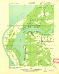 1931 Manistee SW1931 Print · USGSThe Mason County shoreline during the early thirties shows a landscape of bayous and maritime outposts. Genealogists and researchers can locate old landmarks like the Nordhouse Sch, Bridges Resort, and the iconic Big Sable LH.
 - 1931 Map of Custer SE
 1931 Custer SE1931 Print · USGSThe rural borderlands of Mason and Oceana counties are captured here in the early 1930s, showing a landscape of small farmsteads and wetlands. Genealogists can locate family-named landmarks like Carr Sch and Waddell Sch or trace the South Branch Pere Marquette River.
 - 1932 Map of Freesoil SE
 1932 Freesoil SE1932 Print · USGSIn the early 1930s, Mason County’s inland river systems and timbered townships remained largely defined by their water-driven geography. Genealogists and local historians can trace family locations near Millerton, the Round Lake Sch, and the banks of the Big Sable River.2 unique versions available
 - 1932 Map of Ludington NE
 1932 Ludington NE1932 Print · USGSMason County at the start of the 1930s is a landscape of established rural townships and riverside settlements. Genealogists can locate family landmarks like Bethlehem Ch and many local schools including North Amber Sch and Rickey Sch.
 - 1932 Map of Ludington SW
 1932 Ludington SW1932 Print · USGSThe Lake Michigan shoreline of Oceana County is captured here in the early thirties, showing the transition from maritime commerce to recreational use. Genealogists can trace family footprints near Pentwater or find old school sites like Star Valley Sch and Nickerson Sch.
 - 1932 Map of Ludington SE
 1932 Ludington SE1932 Print · USGSThe rural border of Mason and Oceana counties is captured here in the early thirties, showing a landscape of marshy creek bottoms and isolated farmsteads. Local historians can locate vanished community centers at Bucks Corner, Bethel Ch, and Wiley Sch.
 - 1932 Map of Ludington
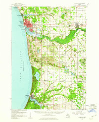
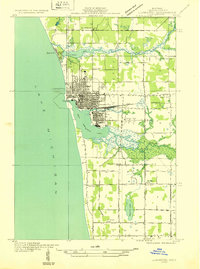 1932 Ludington1932 Print · USGSLudington and the Mason County coast are shown here in the early 1930s as a thriving rail-to-lake transit hub. Researchers can trace the original street grids and find vanished rural landmarks like Eagle Sch, the Grange Hall, and the Ludington & Northern rail line.
 - 1954 Map of Milwaukee, 1967 Print
 1954 Milwaukee1967 Print · USGSCoastal life and maritime commerce across Lake Michigan are seen here during the mid-fifties, bridging Wisconsin's industrial hubs and Michigan's timberlands. Genealogists and historians can trace the rail lines of the Grand Trunk Western and find long-established ports like Ludington, Port Washington, and Muskegon.3 unique versions available
 - 1954 Map of Manitowoc, 1968 Print
 1954 Manitowoc1968 Print · USGSLake Michigan served as a vital transit corridor in the mid-fifties, with car and auto ferries linking the industrial ports of Wisconsin to the Michigan timberlands. Genealogists and maritime historians can trace active ferry routes like the Ann Arbor Railway Car and Auto Ferry and locate early settlements from Brussels to Algoma.2 unique versions available
 - 1957 Map of Freesoil, 1958 Print
 1957 Freesoil1958 Print · USGSNorth of the Mason County line in the late fifties, the landscape is a patchwork of national forest and fading rural school districts. Genealogists can locate family landmarks like Tomaszewski Sch or trace the Chesapeake and Ohio rail line through Freesoil.3 unique versions available
 - 1958 Map of Manitowoc
 1958 Manitowoc1958 Print · USGSLake Michigan and its shorelines are shown in the late fifties when maritime transport defined the region. Researchers can trace the routes of the Ann Arbor Railroad Ferry or locate old settlements like St. Nazianz, Rostock, and Two Creeks.
 - 1958 Map of Milwaukee
 1958 Milwaukee1958 Print · USGSThe shorelines of Lake Michigan in the late fifties reveal a landscape of bustling ferry ports and growing industrial suburbs. Genealogists and historians can trace rail networks like the Chesapeake & Ohio and locate landmarks such as Little Sable Point and Holy Cross Church.
 - 1958 Map of Manistee, 1959 Print
 1958 Manistee1959 Print · USGSThe Lake Michigan shoreline and Manistee River valley appear here in the late fifties, showcasing the region's transition from industrial port to forest recreation. Trace local genealogy and history through landmarks like Stronach, the Old Freesoil Sch, and Sacred Heart Ch.3 unique versions available
 - 1959 Map of Custer, 1960 Print
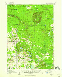
 1959 Custer1960 Print · USGSIn the late fifties, the central Michigan woods around Custer were a landscape of deep national forest and active rail lines. Genealogists and local historians can trace family locations near Crystal Valley, old rural schoolhouses like Elmwood Sch, and several remote Gravel Pits.3 unique versions available
 - 1959 Map of Ludington, 1960 Print
 1959 Ludington1960 Print · USGSMason County and the Lake Michigan shore are captured in the late fifties as a thriving maritime and agricultural region. Researchers can trace the waterfront rail operations of the Chesapeake and Ohio or locate family sites like Smith Corners, Zion Ch, and Lakeview Cem.3 unique versions available
 - 1976 Map of Custer NE
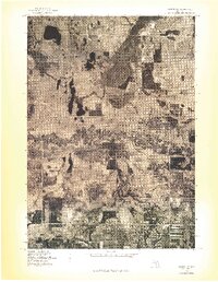 1976 Custer NE1976 Print · USGSMason County forest and farmland appear in striking aerial detail during the mid-1970s. Genealogists and local historians can trace property boundaries and river access points near Tallman, Walhalla, and the winding Pere Marquette River.
 - 1976 Map of Custer NW
 1976 Custer NW1976 Print · USGSThe Mason County countryside is captured in the mid-1970s through this aerial orthophoto, showing the rural landscape around the Custer settlement. You can trace the complex, winding path of the Pere Marquette River as it cuts through local farmsteads.
 - 1976 Map of Custer SW
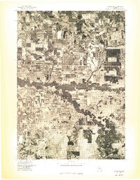
 1976 Custer SW1976 Print · USGSOceana County is captured in mid-1970s aerial detail during this transitional era of rural Michigan life. Genealogists and land researchers can trace the exact buildings and farm footprints of Crystal Valley and the surrounding wooded sections.
 - 1976 Map of Custer SE
 1976 Custer SE1976 Print · USGSCovers Mason County, including Carr, Logan Township, and other nearby areas
 - 1982 Map of Hamlin Lake, 1983 Print
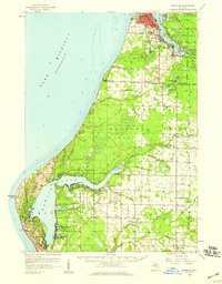
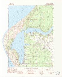 1982 Hamlin Lake1983 Print · USGSThe Mason County shoreline comes to life in this early 1980s survey, showing the intricate bays and peninsulas of the Lake Michigan coast. Genealogists and local historians can locate Hamlin Village, Sacred Heart Ch, and family landmarks like Indian Pete Bayou.2 unique versions available
Showing maps 1-25 of 127
Top cities of Mason County
Frequently asked questions
- What are the different types of historical maps available for Mason County?
- What is the oldest map of Mason County?
- Where can I purchase historical maps of Mason County for my home or office?
- Where can I download high-res historical maps of Mason County?
- Are there historical topographic maps available for Mason County?
- Is there historical aerial imagery available for Mason County?
- Where are historical maps of Mason County sourced from?