1930s Maps of Riverton Township, Michigan
Explore 4 historic maps of Riverton Township from the 1930s. These maps offer a rare glimpse into what life looked like during the 1930s — showing old roads, neighborhoods, homes, and landmarks that have changed or disappeared over time.
Whether you're researching your family's past, planning a metal detecting trip, or studying how Riverton Township's landscape evolved across the 1930s, these high-resolution maps are a powerful tool for exploring the history of this region.
- Focus on a specific era: All maps on this page are from the 1930s, giving you a focused view of this time period.
- See what’s changed: Compare century-old streets, trails, and buildings to today's modern landscape using overlays and satellite layers.
- Research with precision: Use these maps for genealogy, historical research, land use analysis, or educational projects.
- View, download, or print: Maps are fully viewable online in high resolution, and can be downloaded or printed for your own records.
Start exploring Riverton Township's history through authentic maps from the 1930s. This is your window into the past.
Riverton Township, MI maps
(4)- 1932 Map of Ludington NE
 1932 Ludington NE1932 Print · USGSMason County at the start of the 1930s is a landscape of established rural townships and riverside settlements. Genealogists can locate family landmarks like Bethlehem Ch and many local schools including North Amber Sch and Rickey Sch.
 - 1932 Map of Ludington SW
 1932 Ludington SW1932 Print · USGSThe Lake Michigan shoreline of Oceana County is captured here in the early thirties, showing the transition from maritime commerce to recreational use. Genealogists can trace family footprints near Pentwater or find old school sites like Star Valley Sch and Nickerson Sch.
 - 1932 Map of Ludington SE
 1932 Ludington SE1932 Print · USGSThe rural border of Mason and Oceana counties is captured here in the early thirties, showing a landscape of marshy creek bottoms and isolated farmsteads. Local historians can locate vanished community centers at Bucks Corner, Bethel Ch, and Wiley Sch.
 - 1932 Map of Ludington
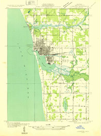 1932 Ludington1932 Print · USGSLudington and the Mason County coast are shown here in the early 1930s as a thriving rail-to-lake transit hub. Researchers can trace the original street grids and find vanished rural landmarks like Eagle Sch, the Grange Hall, and the Ludington & Northern rail line.
End of results
Showing maps 1-4 of 4
Top cities near Riverton Township
- Ludington historical maps
- Amber historical maps
- Hart historical maps
- Weare historical maps
- Scottville historical maps
- Pentwater historical maps
See more
Top neighborhoods of Riverton Township
Frequently asked questions
- What are the different types of historical maps available for Riverton Township?
- What is the oldest map of Riverton Township?
- Where can I purchase historical maps of Riverton Township for my home or office?
- Where can I download high-res historical maps of Riverton Township?
- Are there historical topographic maps available for Riverton Township?
- Is there historical aerial imagery available for Riverton Township?
- Where are historical maps of Riverton Township sourced from?