1980s Maps of Sheridan Township, Michigan
Explore 6 historic maps of Sheridan Township from the 1980s. These maps offer a rare glimpse into what life looked like during the 1980s — showing old roads, neighborhoods, homes, and landmarks that have changed or disappeared over time.
Whether you're researching your family's past, planning a metal detecting trip, or studying how Sheridan Township's landscape evolved across the 1980s, these high-resolution maps are a powerful tool for exploring the history of this region.
- Focus on a specific era: All maps on this page are from the 1980s, giving you a focused view of this time period.
- See what’s changed: Compare century-old streets, trails, and buildings to today's modern landscape using overlays and satellite layers.
- Research with precision: Use these maps for genealogy, historical research, land use analysis, or educational projects.
- View, download, or print: Maps are fully viewable online in high resolution, and can be downloaded or printed for your own records.
Start exploring Sheridan Township's history through authentic maps from the 1980s. This is your window into the past.
Sheridan Township, MI maps
(6)- 1983 Map of Manistee
 1983 Manistee1983 Print · USGSThe Lake Michigan shoreline and the wooded interior of Manistee and Mason Counties are shown here during the early 1980s. Genealogists and historians can trace rail-side towns along the Chesapeake and Ohio or explore old routes like the Old Indian Trail and settlements such as Freesoil and Kaleva.
 - 1983 Map of Ludington, 1984 Print
 1983 Ludington1984 Print · USGSThe Michigan shoreline during the early eighties comes alive in this survey of the dunes and woodlands. Trace the Chesapeake and Ohio rail route through Ludington and Hart, or find family landmarks like Meisenheimer Corners and Wiley.
 - 1987 Map of Millerton, 1988 Print
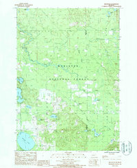 1987 Millerton1988 Print · USGSMason and Lake Counties come alive in the late eighties as a landscape of dense national forest and hidden waterways. Genealogists and historians can trace the paths of several Old RR Grades near Millerton or locate family landmarks around Ford Lake and Round Lake.
 - 1987 Map of Custer, 1988 Print
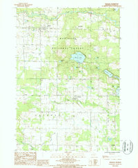
 1987 Custer1988 Print · USGSMason County’s river-carved landscape is shown here in the 1980s, centered on the village of Custer. Researchers can trace old property boundaries and drainage patterns near Whelan Lake, Saunders Lake, and the winding Pere Marquette National Scenic River.
 - 1987 Map of Tallman, 1988 Print
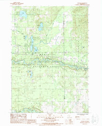 1987 Tallman1988 Print · USGSThe Mason County woodlands during the late 1980s reveal a landscape of secluded glacial lakes and timbered forest. Genealogists and local historians can trace the lakeside settlements of Tallman and Walhalla or follow the path of the Pere Marquette National Scenic River.
 - 1987 Map of Freesoil, 1988 Print
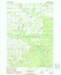
 1987 Freesoil1988 Print · USGSMason County's wooded interior and small village centers are captured in the late eighties, just as the local rail and forest landscapes were evolving. Researchers can trace the C & O RR through Freesoil and Fountain or locate the Camp Sauble State Prison and Gun Lake.
End of results
Showing maps 1-6 of 6
Top cities near Sheridan Township
- Manistee historical maps
- Amber historical maps
- Scottville historical maps
- Oak Hill historical maps
- Eastlake historical maps
- Peacock historical maps
See more
Top neighborhoods of Sheridan Township
Frequently asked questions
- What are the different types of historical maps available for Sheridan Township?
- What is the oldest map of Sheridan Township?
- Where can I purchase historical maps of Sheridan Township for my home or office?
- Where can I download high-res historical maps of Sheridan Township?
- Are there historical topographic maps available for Sheridan Township?
- Is there historical aerial imagery available for Sheridan Township?
- Where are historical maps of Sheridan Township sourced from?