1960s Maps of Daggett Township, Michigan
Explore 4 historic maps of Daggett Township from the 1960s. These maps offer a rare glimpse into what life looked like during the 1960s — showing old roads, neighborhoods, homes, and landmarks that have changed or disappeared over time.
Whether you're researching your family's past, planning a metal detecting trip, or studying how Daggett Township's landscape evolved across the 1960s, these high-resolution maps are a powerful tool for exploring the history of this region.
- Focus on a specific era: All maps on this page are from the 1960s, giving you a focused view of this time period.
- See what’s changed: Compare century-old streets, trails, and buildings to today's modern landscape using overlays and satellite layers.
- Research with precision: Use these maps for genealogy, historical research, land use analysis, or educational projects.
- View, download, or print: Maps are fully viewable online in high resolution, and can be downloaded or printed for your own records.
Start exploring Daggett Township's history through authentic maps from the 1960s. This is your window into the past.
Daggett Township, MI maps
(4)- 1963 Map of Bark River, 1964 Print
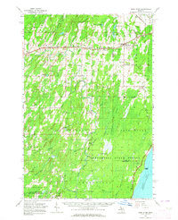 1963 Bark River1964 Print · USGSUpper Peninsula timber and rail communities thrive in the early sixties as the railroad connects the lakeside to the interior. Genealogists can trace family footprints at Hannahville, Indiantown, and the Bark River Cem near Harris.
 - 1963 Map of Powers, 1964 Print
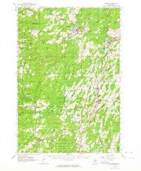 1963 Powers1964 Print · USGSUpper Peninsula timber and rail towns define this mid-century landscape in Menominee County. Genealogists can trace family names through the Swedish Cem and Powers Cem, while the CHICAGO AND NORTH WESTERN line links depots at Nadeau and Carney.
 - 1963 Map of Cedar River, 1964 Print
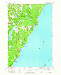 1963 Cedar River1964 Print · USGSThe Menominee County shoreline comes alive in the early 1960s, showing the quiet coastal settlements and timberlands along Green Bay. Researchers can trace family sites from Johnson Landing up to Cedar River, and locate landmarks like the Dominican House of Studies or the Cedar River Cem.3 unique versions available
 - 1963 Map of Stephenson, 1965 Print
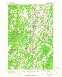 1963 Stephenson1965 Print · USGSThe Menominee River borderlands in the early sixties reveal a network of rail-side timber and farming towns. Genealogists can trace family roots at the Danish Cem, St Marks Ch, or the rural McAllister Sch near the Grand Rapids Dam.
End of results
Showing maps 1-4 of 4
Top cities near Daggett Township
- Spalding historical maps
- Nadeau historical maps
- Stephenson historical maps
- Wagner historical maps
- Powers historical maps
- Gourley historical maps
See more
Top neighborhoods of Daggett Township
Frequently asked questions
- What are the different types of historical maps available for Daggett Township?
- What is the oldest map of Daggett Township?
- Where can I purchase historical maps of Daggett Township for my home or office?
- Where can I download high-res historical maps of Daggett Township?
- Are there historical topographic maps available for Daggett Township?
- Is there historical aerial imagery available for Daggett Township?
- Where are historical maps of Daggett Township sourced from?