1980s Maps of Missaukee County, Michigan
Explore 23 historic maps of Missaukee County from the 1980s. These maps offer a rare glimpse into what life looked like during the 1980s — showing old roads, neighborhoods, homes, and landmarks that have changed or disappeared over time.
Whether you're researching your family's past, planning a metal detecting trip, or studying how Missaukee County's landscape evolved across the 1980s, these high-resolution maps are a powerful tool for exploring the history of this region.
- Focus on a specific era: All maps on this page are from the 1980s, giving you a focused view of this time period.
- See what’s changed: Compare century-old streets, trails, and buildings to today's modern landscape using overlays and satellite layers.
- Research with precision: Use these maps for genealogy, historical research, land use analysis, or educational projects.
- View, download, or print: Maps are fully viewable online in high resolution, and can be downloaded or printed for your own records.
Start exploring Missaukee County's history through authentic maps from the 1980s. This is your window into the past.
Missaukee County, MI maps
(23)- 1983 Map of Cadillac, 1984 Print
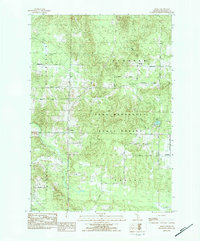
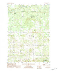
 1983 Cadillac1984 Print · USGSThe Cadillac region in the early eighties was defined by its vast public forests and the prominent dual lakes at its center. Trace the legacies of the timber era along the Old Railroad Grade or locate old rural centers like Vogel Center and Harrietta.
 - 1983 Map of Meads Landing, 1984 Print
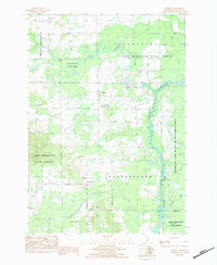
 1983 Meads Landing1984 Print · USGSUpper Michigan's lake country in the early eighties shows a landscape of state forests and sprawling wetlands between the Great Lakes. You can locate family history at Heidemann Cem, trace the oil production at the Enterprise Oil Field, or find old river crossings near the Covered Bridge.
 - 1983 Map of Moddersville, 1984 Print
 1983 Moddersville1984 Print · USGSThe Moddersville area and the upper reaches of the Muskegon River are documented here in the early eighties. Genealogists and local historians can locate the West Moddersville Cem, the Townhall, and the riverside settlement of Leota.2 unique versions available
 - 1983 Map of Stittsville, 1984 Print
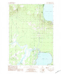
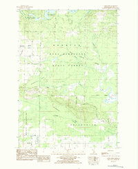
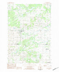
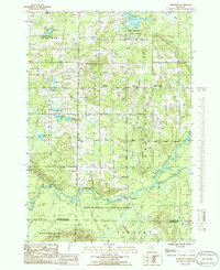
 1983 Stittsville1984 Print · USGSMissaukee County's wooded interior is captured here in the early 1980s, showing a landscape defined by state forest lands and quiet crossroads. Researchers can locate the Pioneer Cem, the historic Townhall, and old settlement sites at Moorestown and Stittsville.
 - 1983 Map of Lake City, 1984 Print
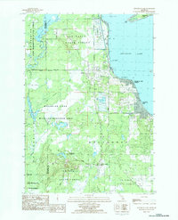
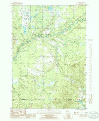
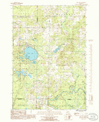
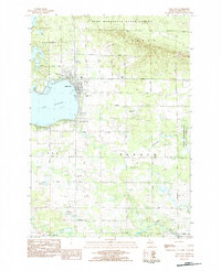 1983 Lake City1984 Print · USGSMissaukee County’s lakeside character is on full display in the early eighties as the town of Lake City expands along Lake Missaukee. Genealogists and local historians can locate community landmarks like St Johns Ch, the Home Acres Airport, and family-named routes such as Walenjus Road.
 - 1983 Map of Addis Creek, 1984 Print
 1983 Addis Creek1984 Print · USGSMissaukee County's forest and swamp lands are captured here in the early 1980s, showcasing a landscape of wildlife management and remote settlements. Researchers can trace family history at Moorestown Cem or locate the old Stratford Dam and Star City.
 - 1983 Map of Dinca, 1984 Print
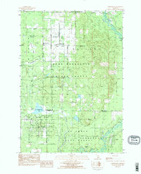
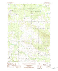 1983 Dinca1984 Print · USGSMissaukee County's rural townships are captured here in the early 1980s, where the state forest meets quiet farming communities. Researchers can locate family sites and civic landmarks like the Reeder and Aetna cemeteries, the Townhall, and Aetna Ch.
 - 1983 Map of Falmouth, 1984 Print
 1983 Falmouth1984 Print · USGSMissaukee and Osceola counties in the early 1980s reveal a landscape of river-bottom farming and emerging energy fields. Genealogists and local historians can trace the rural communities of Falmouth and Vogel Center, locating family landmarks like the Clam Union Cem and Prosper Ch.
 - 1983 Map of Houghton Lake, 1984 Print
 1983 Houghton Lake1984 Print · USGSHoughton Lake and its surrounding wetlands are shown in detail during the early 1980s as the area balanced recreation with state forest management. Researchers can trace local development in Houghton Lake Heights, find the Township Cem, or locate the inland settlement of Nellsville.2 unique versions available
 - 1983 Map of Houghton Lake, 1984 Print
 1983 Houghton Lake1984 Print · USGSIn the early 1980s, the Michigan heartland around Houghton Lake was a patchwork of state forest and growing lakeside resorts. Genealogists and historians can trace the development of communities like West Branch and Rose City alongside landmarks like Roscommon County Airfield.
 - 1983 Map of Traverse City, 1984 Print
 1983 Traverse City1984 Print · USGSTraverse City and the surrounding bay country are captured in the early eighties as the region balanced its timber heritage with growing conservation. Genealogists and local historians can trace the rail lines of the Ann Arbor RR through settlements like Kingsley and Fife Lake.2 unique versions available
 - 1983 Map of Morey, 1984 Print
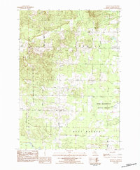
 1983 Morey1984 Print · USGSMissaukee County's wooded interior and small rural settlements are captured here in the early 1980s as the state forest system expanded. Genealogists can locate family landmarks like Morey Ch and trace the original township footprints of Bloomfield and Pioneer.
 - 1983 Map of Jennings, 1984 Print
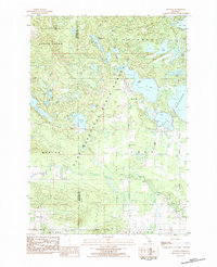 1983 Jennings1984 Print · USGSJennings and the surrounding state forest are captured here in the early eighties, showcasing a region defined by its numerous lakes and timber heritage. Genealogists can locate both the Old Jennings Cem and New Jennings Cem, while history buffs can trace the path of the Lake City Railway.
 - 1983 Map of Cooperton, 1984 Print
 1983 Cooperton1984 Print · USGSThe Muskegon River oxbows through the Michigan timberlands in the early eighties, marking the intersection of the Missaukee, Roscommon, and Clare county lines. Researchers can trace forest development near Cooperton and locate remote sites like Wraco Lodge Lake and the Bear Creek Dam.
 - 1983 Map of Grayling, 1984 Print
 1983 Grayling1984 Print · USGSIn the early eighties, this Northern Michigan interior was a hub for forestry, military training, and river recreation. Researchers can trace the sprawling boundaries of Camp Grayling and locate historic markers like Hartwick Pines and Otsego Lake.2 unique versions available
 - 1983 Map of Lucas, 1984 Print
 1983 Lucas1984 Print · USGSMissaukee and Wexford counties are captured in the early eighties as a network of rural townships centered on the village of Lucas. Genealogists and local historians can trace family roots through sites like Richland Cem, the Lucas-McBain Sch, and the Michigan Northern railroad.2 unique versions available
 - 1983 Map of Arlene, 1984 Print
 1983 Arlene1984 Print · USGSMissaukee and Wexford counties are shown here in the early 1980s, where the state forest meets rural township life. Genealogists and local historians can locate Caldwell Ch, the Bloomfield Cemetery, and the riverfront Whip-Poor-Will Landing Strip.
 - 1983 Map of Merritt, 1984 Print
 1983 Merritt1984 Print · USGSMissaukee County's wooded lowlands and river bends are captured here in the early eighties, showcasing a landscape defined by state forests and small rural settlements. Researchers can trace family history at the Star City Cem or locate the old Prosper Oil Field and the winding Muskegon River.
 - 1983 Map of McBain, 1984 Print
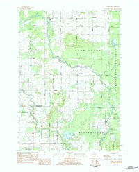
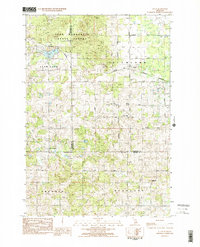
 1983 McBain1984 Print · USGSMcBain and the surrounding townships of Missaukee County appear here in the early eighties as a patchwork of productive farmsteads and managed wetlands. Genealogists can locate family names and burial sites at Mt View Cem, Calvin Ch, and Park Lake Cem.
 - 1985 Map of Sharon, 1986 Print
 1985 Sharon1986 Print · USGSKalkaska County's river valleys and state forest lands are captured in the mid-1980s, showcasing a landscape of timber, gas extraction, and wilderness. Researchers can trace the Old RR Grade and locate the Cannon Creek Gas Field near the settlement of Sharon.
 - 1985 Map of Smithville, 1986 Print
 1985 Smithville1986 Print · USGSThe Manistee River valley in the mid-1980s reveals a quiet landscape of state forest and scattered rural settlements. Researchers can trace the Old RR Grade and locate long-standing landmarks like Smithville, Taffeltown, and the Gem Township Hall.
 - 1985 Map of Fife Lake, 1986 Print
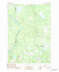
 1985 Fife Lake1986 Print · USGSThe Fife Lake region in the mid-1980s shows a landscape of glacial lakes and extensive timberlands managed by the Pere Marquette State Forest. Genealogists and local historians can trace the shoreline of Fife Lake, locate the community of Houseman, and follow the southern bend of the Manistee River.
 - 1989 Map of Traverse City, 1990 Print
 1989 Traverse City1990 Print · USGSNorthern Michigan’s lake-country and forest lands are captured in the late eighties as seasonal tourism and timber hubs expanded. Genealogists and historians can trace the routes of the Ann Arbor RR, the boundaries of Camp Grayling, and settlements like Elk Rapids and Manton.
End of results
Showing maps 1-23 of 23
Top cities of Missaukee County
Frequently asked questions
- What are the different types of historical maps available for Missaukee County?
- What is the oldest map of Missaukee County?
- Where can I purchase historical maps of Missaukee County for my home or office?
- Where can I download high-res historical maps of Missaukee County?
- Are there historical topographic maps available for Missaukee County?
- Is there historical aerial imagery available for Missaukee County?
- Where are historical maps of Missaukee County sourced from?