1980s Maps of Bridgeton Township, Michigan
Explore 7 historic maps of Bridgeton Township from the 1980s. These maps offer a rare glimpse into what life looked like during the 1980s — showing old roads, neighborhoods, homes, and landmarks that have changed or disappeared over time.
Whether you're researching your family's past, planning a metal detecting trip, or studying how Bridgeton Township's landscape evolved across the 1980s, these high-resolution maps are a powerful tool for exploring the history of this region.
- Focus on a specific era: All maps on this page are from the 1980s, giving you a focused view of this time period.
- See what’s changed: Compare century-old streets, trails, and buildings to today's modern landscape using overlays and satellite layers.
- Research with precision: Use these maps for genealogy, historical research, land use analysis, or educational projects.
- View, download, or print: Maps are fully viewable online in high resolution, and can be downloaded or printed for your own records.
Start exploring Bridgeton Township's history through authentic maps from the 1980s. This is your window into the past.
Bridgeton Township, MI maps
(7)- 1982 Map of Muskegon
 1982 Muskegon1982 Print · USGSThe West Michigan shoreline during the early eighties shows a bustling industrial and maritime landscape centered on Muskegon Lake and Grand Haven. Researchers can trace rail history along the Grand Trunk Western or locate local landmarks like Oakwood Cem and Cloverville.
 - 1985 Map of Fremont
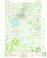 1985 Fremont1985 Print · USGSNewaygo County in the mid-eighties shows a landscape of glacial lakes and small-town growth around Fremont. Genealogists and local historians can trace family locations near Maple Grove Cemetery or the rural settlement of Bishop near the Muskegon River.
 - 1985 Map of Holton
 1985 Holton1985 Print · USGSThe borders of Muskegon, Oceana, and Newaygo counties meet here in the mid-1980s, centered on the settlement of Holton. Researchers can trace local family lineages through St Micheals Ch, Evans Cem, and the rural community at Brunswick.
 - 1985 Map of Cedar Springs
 1985 Cedar Springs1985 Print · USGSThe northern reaches of the Grand Rapids metro area meet the forests of the Manistee during the mid-eighties. Genealogists and historians can trace the paths of the Grand Trunk Western RR through Sparta or locate rural landmarks near Cedar Springs and Rockford.
 - 1985 Map of Wolf Lake
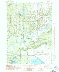 1985 Wolf Lake1985 Print · USGSMuskegon County is shown in the mid-eighties as a region defined by river confluences and large-scale conservation lands. Genealogists and local historians can locate St Anthonys Cem, the John F Kennedy Memorial Park, and the unique Muskegon Wastewater Management System.
 - 1985 Map of Bridgeton
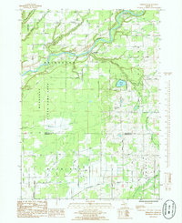 1985 Bridgeton1985 Print · USGSThe Muskegon River valley in the early 1980s reveals a mix of conservation lands and rural township life. Genealogists and local historians can locate the Bridgeton Ch, the village of Trent, and the small Cem tucked near the Muskegon River banks.
 - 1986 Map of Cedar Springs, 1989 Print
 1986 Cedar Springs1989 Print · USGSThe northern suburbs of Grand Rapids meet the Manistee National Forest in the mid-1980s. Genealogists and historians can trace the rail-side growth of Howard City, Rockford, and Greenville along the C & O RR and Flat River.
End of results
Showing maps 1-7 of 7
Top cities near Bridgeton Township
- Muskegon historical maps
- Spring Lake Township historical maps
- Alpine Township historical maps
- Fremont historical maps
- Wolf Lake historical maps
- Wright historical maps
See more
Top neighborhoods of Bridgeton Township
Frequently asked questions
- What are the different types of historical maps available for Bridgeton Township?
- What is the oldest map of Bridgeton Township?
- Where can I purchase historical maps of Bridgeton Township for my home or office?
- Where can I download high-res historical maps of Bridgeton Township?
- Are there historical topographic maps available for Bridgeton Township?
- Is there historical aerial imagery available for Bridgeton Township?
- Where are historical maps of Bridgeton Township sourced from?