Old Maps of Oakland County, Michigan
Explore 269 old maps of Oakland County, spanning from 1902 to today. These high-resolution historic maps reveal how streets, neighborhoods, landmarks, and natural features evolved over time — perfect for genealogy, metal detecting, research, and local history exploration.
What you can do with these maps:
- See how Oakland County changed over time: Compare historical maps to modern-day views to trace roads, homesites, rail lines & more.
- View detailed metadata: Each map includes creators, publishers, year, scale, and archive source.
- Overlay maps with satellite & LiDAR: Visualize the past alongside modern tools to explore terrain & human change.
- Trusted historical sources: Maps sourced from the USGS, Library of Congress, and other archives.
- Access maps your way: View online, download high-res files, or order prints for personal or research use.
Start exploring old maps of Oakland County to uncover forgotten places, hidden landmarks, and the deep history beneath your feet.
Oakland County, MI maps
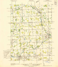
(269)- 1902 Map of South Lyon, 1954 Print
 1902 South Lyon1954 Print · USGSSoutheast Michigan at the turn of the century reveals a landscape of thriving rail junctions and rural townships across Oakland and Washtenaw counties. Trace the early footprints of Ann Arbor and South Lyon alongside historic whistle-stops like Emery and Geddes.
 - 1904 Map of Ann Arbor
 1904 Ann Arbor1904 Print · USGSEarly twentieth-century Washtenaw County comes to life through its dense network of interurban electric lines and steam railroads. Researchers can trace the layout of Ann Arbor, locate the Duck Lake School, or find vanished stops along the Michigan Central R. R. and Ann Arbor R. R..2 unique versions available
 - 1905 Map of Wayne
 1905 Wayne1905 Print · USGSWestern Wayne and southern Oakland counties are seen here at a pivotal moment when electric interurban railways first linked rural townships. Genealogists can trace family footprints in Northville, Plymouth, and Farmington, or locate vanished landmarks like Perrinville and the Wayne County Home.4 unique versions available
 - 1905 Map of Detroit
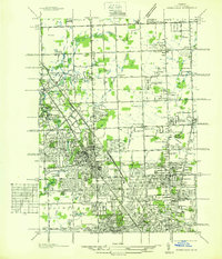
 1905 Detroit1905 Print · USGSDetroit and its surrounding townships are shown at a pivotal moment of expansion during the early 1900s. Genealogists and historians can trace the development of early suburbs like Highland Park and Royal Oak along major transit arteries like Grand River Ave. and the numerous electric railways.2 unique versions available
 - 1906 Map of South Lyon
 1906 South Lyon1906 Print · USGSSoutheast Michigan at the turn of the century shows a landscape defined by an intricate web of steam and electric railways. Researchers can trace the early layouts of Ann Arbor and South Lyon, or locate smaller depots like Whitmore Lake Station and Rushton.5 unique versions available
 - 1907 Map of Pontiac
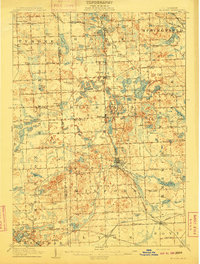
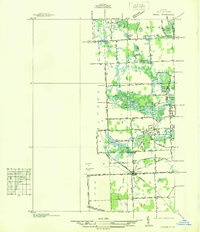
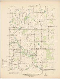
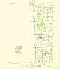
 1907 Pontiac1907 Print · USGSOakland County is captured here at a pivotal moment when early electric railways and the Grand Trunk line first connected these lake communities. Trace historic institutional landmarks like the Asylum and Military Academy alongside the Bigelow Mill.5 unique versions available
 - 1908 Map of Ann Arbor
 1908 Ann Arbor1908 Print · USGSSoutheast Michigan at the turn of the century shows a landscape transitioning through the arrival of electric rail and the growth of the Huron River valley. Genealogists and researchers can trace old family lands near Saline, Ypsilanti, and Whitmore Lake, or follow the path of the Michigan Central RR.
 - 1908 Map of Rochester
 1908 Rochester1908 Print · USGSSoutheast Michigan at the turn of the century shows a bustling landscape of early electric railways and rural township life. Genealogists and local historians can trace the foundations of Rochester, Birmingham, and Utica, alongside vanished landmarks like Snell School and the Stone Shop.3 unique versions available
 - 1909 Map of Milford
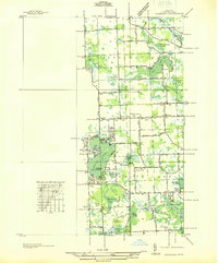
 1909 Milford1909 Print · USGSIn the decade before the automobile era, this area of Oakland County was a patchwork of lakefront settlements and busy rail junctions. Genealogists can trace family footprints near Spring Mills or rural landmarks like the Remington Church and Kenny School.4 unique versions available
 - 1912 Map of Wayne
 1912 Wayne1912 Print · USGSWestern Wayne County in the early twentieth century shows a landscape being reshaped by the first concrete roads and a dense network of electric interurban railways. Trace the early development of Livonia, Redford, and Plymouth, or locate long-standing sites like Eloise and Perrinville.
 - 1918 Map of Detroit
 1918 Detroit1918 Print · USGSDetroit and its surrounding townships appear at the height of the early industrial era, captured just after the close of the Great War. Local researchers can trace the growth of the Ford Motor Co. empire near Navarre P.O. and explore the historic rail corridors of Hamtramck and Royal Oak.
 - 1920 Map of Holly, 1964 Print
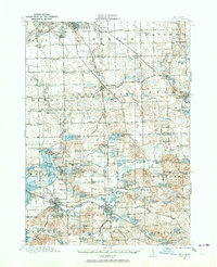 1920 Holly1964 Print · USGSOakland and Genesee counties at the height of the rail era show a landscape of interconnected small towns and lakeside settlements. Trace the legacy of early transit via the United Electric Railway or locate family landmarks like Groveland Mills and Hadley Cemetery.
 - 1922 Map of Holly
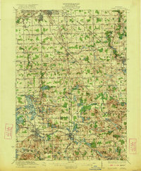 1922 Holly1922 Print · USGSSoutheast of the industrial rise of Flint in the early 1920s, this region reveals a landscape of lakeside settlements and small-town village life. Genealogists can locate family-named sites like Ainsworth Corners, Gravel Lake Cemetery, and dozens of rural schoolhouses including Atherton School and Howe School.3 unique versions available
 - 1924 Map of Detroit
 1924 Detroit1924 Print · USGSDetroit and its industrial satellites thrive during the peak of the automotive era. Genealogists and historians can trace the early factory footprints of Dodge Bros. or locate old neighborhood landmarks like Navarre P. O. and Mt. Olivet Cemetery.
 - 1934 Map of Detroit
 1934 Detroit1934 Print · USGSThe Detroit riverfront and its rising industrial suburbs are captured here during the peak of the automotive boom. Genealogists and historians can trace the early footprints of the Ford Motor Co and local landmarks like Olivet Cemetery or the State Fair Grounds.
 - 1936 Map of Warren
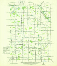 1936 Warren1936 Print · USGSThe Macomb and Oakland county line in the mid-1930s shows a landscape of small townships and early subdivisions. Genealogists can trace family roots through numerous local schools like Berz Sch or find historic burials at Warren Cem and Memorial Park Cem.
 - 1936 Map of Birmingham
 1936 Birmingham1936 Print · USGSOakland County was undergoing a massive suburban transformation in the mid-thirties as the Detroit metropolitan area expanded northward. Trace the early development of Birmingham and Royal Oak, and find vanished landmarks like Charing Cross Sta or the Log Cabin High Sch.
 - 1936 Map of Wixom
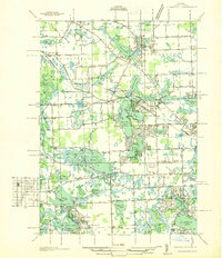
 1936 Wixom1936 Print · USGSOakland County's lake district is documented here in the mid-1930s, showing the intersection of rural agriculture and growing recreation. Trace family history at Wixom Cem or locate former landmarks like Stone Sch and the Pere Marquette rail line.
 - 1936 Map of Highland
 1936 Highland1936 Print · USGSOakland County's lake-rich landscape is captured in the mid-1930s, showing the early residential development around White Lake and the Huron River. Genealogists and local historians can trace the locations of the White Lake Center Sch, Seven Harbors, and the historic White Lake Cem.
 - 1936 Map of Clarkston
 1936 Clarkston1936 Print · USGSOakland County during the mid-1930s shows a landscape of interconnected lakes and early suburban growth near the Clinton River. Genealogists and local historians can trace schoolhouse locations like Dublin Sch and Granger Sch, or explore the rail-era infrastructure of the Grand Trunk Western.
 - 1936 Map of Rochester
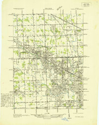
 1936 Rochester1936 Print · USGSOakland County was witnessing a surge in residential planning during the mid-1930s as new subdivisions began to fill the space between established towns. Genealogists and historians can trace numerous rural schoolhouses like Ross Sch and Hamlin Sch, or explore the early footprints of the Dodge Subdivision and Rochester.
 - 1936 Map of Washington
 1936 Washington1936 Print · USGSMacomb County townships were transitioning from rural agriculture to automotive industry in the mid-1930s. Genealogists and historians can trace the Packard Proving Grounds, Ferry Morse Seed Co Farms, and old burial sites like Washington Cem.
 - 1936 Map of Redford
 1936 Redford1936 Print · USGSNorthwestern Detroit suburbs emerge from farm tracts during the mid-1930s, showing early neighborhoods and grid-road expansion. Genealogists can find numerous burial grounds like Grand Lawn Cem and landmarks such as Bell Br Community Ch and the Redford Post Office.
 - 1936 Map of Highland Park
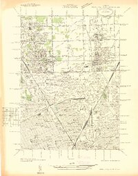 1936 Highland Park1936 Print · USGSGreater Detroit and the enclaves of Highland Park and Hamtramck are captured here in the mid-1930s as urban growth pushes north. Researchers can pinpoint early neighborhoods, local schools like Henry Ford Sch, and the grounds of the Michigan State Fair.
 - 1936 Map of Salem
 1936 Salem1936 Print · USGSNorthwestern Wayne County and southern Oakland County are captured in the mid-1930s before postwar suburbanization. Genealogists and local researchers can trace old family section lines and find landmark institutions like the Maybury Sanitarium and West Novi Sch.
Showing maps 1-25 of 269
Top cities of Oakland County
- Troy historical maps
- Farmington Hills historical maps
- Rochester Hills historical maps
- Southfield historical maps
- Waterford Township historical maps
- Novi historical maps
See more
Frequently asked questions
- What are the different types of historical maps available for Oakland County?
- What is the oldest map of Oakland County?
- Where can I purchase historical maps of Oakland County for my home or office?
- Where can I download high-res historical maps of Oakland County?
- Are there historical topographic maps available for Oakland County?
- Is there historical aerial imagery available for Oakland County?
- Where are historical maps of Oakland County sourced from?