1940s Maps of Brandon Gardens, Brandon Charter Township
Explore 2 historic maps of Brandon Gardens from the 1940s. These maps offer a rare glimpse into what life looked like during the 1940s — showing old roads, neighborhoods, homes, and landmarks that have changed or disappeared over time.
Whether you're researching your family's past, planning a metal detecting trip, or studying how Brandon Gardens's landscape evolved across the 1940s, these high-resolution maps are a powerful tool for exploring the history of this region.
- Focus on a specific era: All maps on this page are from the 1940s, giving you a focused view of this time period.
- See what’s changed: Compare century-old streets, trails, and buildings to today's modern landscape using overlays and satellite layers.
- Research with precision: Use these maps for genealogy, historical research, land use analysis, or educational projects.
- View, download, or print: Maps are fully viewable online in high resolution, and can be downloaded or printed for your own records.
Start exploring Brandon Gardens's history through authentic maps from the 1940s. This is your window into the past.
Brandon Gardens, Brandon Charter Township maps
(2)- 1943 Map of Ortonville, 1959 Print
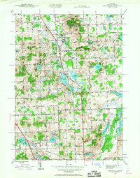 1943 Ortonville1959 Print · USGSDuring the early 1940s, the village of Ortonville and the surrounding townships remained a landscape of country schools and glacial lakes. Genealogists can locate family landmarks like Eaton Cem, Mt Bethel Ch, and the Seymour Lake Sch.
 - 1945 Map of Ortonville
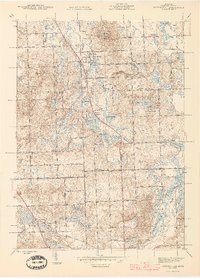 1945 Ortonville1945 Print · USGSNorthwestern Oakland County during the mid-forties reveals a landscape of lakeside communities and rural schools just as post-war growth began. Genealogists can locate family landmarks like Jossman Acres, Mt Bethel Ch, and the Union Brandon Sch.2 unique versions available
End of results
Showing maps 1-2 of 2
Top cities near Brandon Gardens
- Flint historical maps
- Waterford Township historical maps
- West Bloomfield Township historical maps
- Pontiac historical maps
- Commerce Charter Township historical maps
- Orion Charter Township historical maps
See more
Frequently asked questions
- What are the different types of historical maps available for Brandon Gardens?
- What is the oldest map of Brandon Gardens?
- Where can I purchase historical maps of Brandon Gardens for my home or office?
- Where can I download high-res historical maps of Brandon Gardens?
- Are there historical topographic maps available for Brandon Gardens?
- Is there historical aerial imagery available for Brandon Gardens?
- Where are historical maps of Brandon Gardens sourced from?