1950s Maps of Novi, Michigan
Explore 5 historic maps of Novi from the 1950s. These maps offer a rare glimpse into what life looked like during the 1950s — showing old roads, neighborhoods, homes, and landmarks that have changed or disappeared over time.
Whether you're researching your family's past, planning a metal detecting trip, or studying how Novi's landscape evolved across the 1950s, these high-resolution maps are a powerful tool for exploring the history of this region.
- Focus on a specific era: All maps on this page are from the 1950s, giving you a focused view of this time period.
- See what’s changed: Compare century-old streets, trails, and buildings to today's modern landscape using overlays and satellite layers.
- Research with precision: Use these maps for genealogy, historical research, land use analysis, or educational projects.
- View, download, or print: Maps are fully viewable online in high resolution, and can be downloaded or printed for your own records.
Start exploring Novi's history through authentic maps from the 1950s. This is your window into the past.
Novi, MI maps
(5)- 1952 Map of Northville, 1954 Print
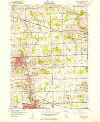 1952 Northville1954 Print · USGSThe settlement of Novi is shown at a pivotal moment in the early fifties before the rapid growth of the Detroit suburbs. Genealogists and local historians can trace the historical layout and early road systems centered around Novi.2 unique versions available
 - 1952 Map of Walled Lake, 1954 Print
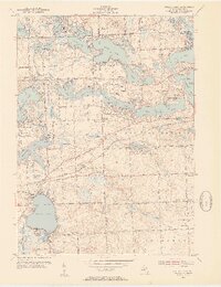 1952 Walled Lake1954 Print · USGSOakland County's lake country is captured here in the early fifties, showing a landscape of burgeoning summer retreats and established farmsteads. Researchers can locate family landmarks such as the Richardson Cem, the North Farmington Cem, and local schools like Bassett Sch.3 unique versions available
 - 1953 Map of Salem, 1955 Print
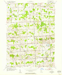 1953 Salem1955 Print · USGSSoutheast Michigan’s rural townships are captured here in the early 1950s as small farming communities began to interface with large county institutions. Researchers can trace family sites near Salem and Brookville, or locate landmarks like Thayer Cem and the Maybury Sanitarium.
 - 1954 Map of Detroit
 1954 Detroit1954 Print · USGSThe Detroit metro and its Ontario neighbors are shown at the height of the mid-century industrial era, just as the suburbs were rapidly expanding. Researchers can trace the massive rail networks of the Wabash Railroad or locate landmarks like Grosse Ile and Selfridge Air Force Base.
 - 1954 Map of Milford, 1955 Print
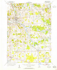 1954 Milford1955 Print · USGSOakland County's lake country is captured here in the mid-fifties, showing the evolution of Milford and New Hudson before modern suburban sprawl. Researchers can trace the Huron River corridor, locate the New Hudson Airport, and find early local landmarks like Glengary and the Hickory Hill Golf Club.
End of results
Showing maps 1-5 of 5
Top cities near Novi
- Detroit historical maps
- Ann Arbor historical maps
- Canton Charter Township historical maps
- Canton Township historical maps
- Livonia historical maps
- Dearborn historical maps
See more
Top neighborhoods of Novi
Frequently asked questions
- What are the different types of historical maps available for Novi?
- What is the oldest map of Novi?
- Where can I purchase historical maps of Novi for my home or office?
- Where can I download high-res historical maps of Novi?
- Are there historical topographic maps available for Novi?
- Is there historical aerial imagery available for Novi?
- Where are historical maps of Novi sourced from?