1980s Maps of Grant Township, Michigan
Explore 6 historic maps of Grant Township from the 1980s. These maps offer a rare glimpse into what life looked like during the 1980s — showing old roads, neighborhoods, homes, and landmarks that have changed or disappeared over time.
Whether you're researching your family's past, planning a metal detecting trip, or studying how Grant Township's landscape evolved across the 1980s, these high-resolution maps are a powerful tool for exploring the history of this region.
- Focus on a specific era: All maps on this page are from the 1980s, giving you a focused view of this time period.
- See what’s changed: Compare century-old streets, trails, and buildings to today's modern landscape using overlays and satellite layers.
- Research with precision: Use these maps for genealogy, historical research, land use analysis, or educational projects.
- View, download, or print: Maps are fully viewable online in high resolution, and can be downloaded or printed for your own records.
Start exploring Grant Township's history through authentic maps from the 1980s. This is your window into the past.
Grant Township, MI maps
(6)- 1982 Map of Muskegon
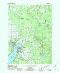
 1982 Muskegon1982 Print · USGSThe West Michigan shoreline during the early eighties shows a bustling industrial and maritime landscape centered on Muskegon Lake and Grand Haven. Researchers can trace rail history along the Grand Trunk Western or locate local landmarks like Oakwood Cem and Cloverville.
 - 1983 Map of Montague
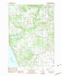
 1983 Montague1983 Print · USGSThe twin cities of Montague and Whitehall sit at the mouth of the White River in the early eighties. Trace local genealogy and landmarks across White Lake, finding St James Ch, Oakwood Cem, and the tracks of the Chesapeake and Ohio.
 - 1983 Map of Town Corners
 1983 Town Corners1983 Print · USGSWestern Oceana County in the early eighties shows a landscape of coastal lakes and active oil production near the Michigan shore. Researchers can trace family sites at Gardner Cem and Cranston Cem, or locate the Stony Lake Oil Field and the rural center at Town Corners.2 unique versions available
 - 1983 Map of Shelby
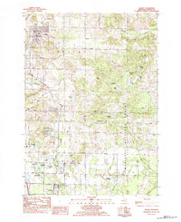 1983 Shelby1983 Print · USGSSouthern Oceana County appears in the early eighties as a corridor of small-town life and timberland. Trace the rail-side growth of Shelby, New Era, and Rothbury, or locate family sites at Mount Hope Cem and Assumption Cem.
 - 1983 Map of Flower Creek
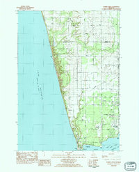 1983 Flower Creek1983 Print · USGSThe Lake Michigan shoreline of Muskegon and Oceana counties is shown here in the early eighties. Genealogists can trace family names through landmarks like Hubbard Cem and Green Sch, or follow the Chesapeake and Ohio rail corridor.
 - 1983 Map of Ludington, 1984 Print
 1983 Ludington1984 Print · USGSThe Michigan shoreline during the early eighties comes alive in this survey of the dunes and woodlands. Trace the Chesapeake and Ohio rail route through Ludington and Hart, or find family landmarks like Meisenheimer Corners and Wiley.
End of results
Showing maps 1-6 of 6
Top cities near Grant Township
- Dalton historical maps
- Whitehall historical maps
- Montague historical maps
- Hart historical maps
- Shelby historical maps
- Twin Lake historical maps
See more
Top neighborhoods of Grant Township
Frequently asked questions
- What are the different types of historical maps available for Grant Township?
- What is the oldest map of Grant Township?
- Where can I purchase historical maps of Grant Township for my home or office?
- Where can I download high-res historical maps of Grant Township?
- Are there historical topographic maps available for Grant Township?
- Is there historical aerial imagery available for Grant Township?
- Where are historical maps of Grant Township sourced from?