1970s Maps of Leavitt Township, Michigan
Explore 2 historic maps of Leavitt Township from the 1970s. These maps offer a rare glimpse into what life looked like during the 1970s — showing old roads, neighborhoods, homes, and landmarks that have changed or disappeared over time.
Whether you're researching your family's past, planning a metal detecting trip, or studying how Leavitt Township's landscape evolved across the 1970s, these high-resolution maps are a powerful tool for exploring the history of this region.
- Focus on a specific era: All maps on this page are from the 1970s, giving you a focused view of this time period.
- See what’s changed: Compare century-old streets, trails, and buildings to today's modern landscape using overlays and satellite layers.
- Research with precision: Use these maps for genealogy, historical research, land use analysis, or educational projects.
- View, download, or print: Maps are fully viewable online in high resolution, and can be downloaded or printed for your own records.
Start exploring Leavitt Township's history through authentic maps from the 1970s. This is your window into the past.
Leavitt Township, MI maps
(2)- 1976 Map of Hersperia NW
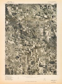 1976 Hersperia NW1976 Print · USGSOceana County’s rural landscape is preserved in striking aerial detail during the mid-seventies. Local historians and land researchers can trace property lines and farmstead locations near Walkerville and the scattered settlement of Elbridge.
 - 1976 Map of Hersperia NE
 1976 Hersperia NE1976 Print · USGSThe rural landscape of Oceana County is captured in the mid-1970s through this detailed aerial survey. Researchers can trace the layout of Walkerville and examine the exact boundaries of farms and woodlots across the township.
End of results
Showing maps 1-2 of 2
Top cities near Leavitt Township
- Fremont historical maps
- Ferry historical maps
- Elbridge historical maps
- Hesperia historical maps
- Colfax historical maps
- Troy historical maps
See more
Top neighborhoods of Leavitt Township
Frequently asked questions
- What are the different types of historical maps available for Leavitt Township?
- What is the oldest map of Leavitt Township?
- Where can I purchase historical maps of Leavitt Township for my home or office?
- Where can I download high-res historical maps of Leavitt Township?
- Are there historical topographic maps available for Leavitt Township?
- Is there historical aerial imagery available for Leavitt Township?
- Where are historical maps of Leavitt Township sourced from?