1970s Maps of Otto Township, Michigan
Explore 4 historic maps of Otto Township from the 1970s. These maps offer a rare glimpse into what life looked like during the 1970s — showing old roads, neighborhoods, homes, and landmarks that have changed or disappeared over time.
Whether you're researching your family's past, planning a metal detecting trip, or studying how Otto Township's landscape evolved across the 1970s, these high-resolution maps are a powerful tool for exploring the history of this region.
- Focus on a specific era: All maps on this page are from the 1970s, giving you a focused view of this time period.
- See what’s changed: Compare century-old streets, trails, and buildings to today's modern landscape using overlays and satellite layers.
- Research with precision: Use these maps for genealogy, historical research, land use analysis, or educational projects.
- View, download, or print: Maps are fully viewable online in high resolution, and can be downloaded or printed for your own records.
Start exploring Otto Township's history through authentic maps from the 1970s. This is your window into the past.
Otto Township, MI maps
(4)- 1976 Map of Hersperia SW
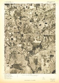 1976 Hersperia SW1976 Print · USGSWestern Michigan’s rural landscape is captured through detailed aerial photography in the mid-seventies. Trace the roads and field patterns surrounding the small settlement of Ferry and examine the natural drainage of the local river systems.
 - 1976 Map of Hart SE
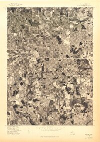 1976 Hart SE1976 Print · USGSOceana County is shown in remarkable aerial detail during the mid-seventies, capturing the agricultural heart of west Michigan. Genealogists and local historians can trace exact farmstead locations and rural boundaries surrounding Shelby, New Era, and Rothbury.
 - 1976 Map of Montague NE, 1979 Print
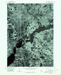 1976 Montague NE1979 Print · USGSSettlements along the Michigan coast are captured from above during the mid-seventies, showing the developed centers of Montague and Whitehall. Genealogists and historians can trace local property layouts and neighborhood growth in Maple Grove and Lakewood.
 - 1976 Map of Twin Lake NW, 1979 Print
 1976 Twin Lake NW1979 Print · USGSMuskegon County's lake-strewn landscape is captured in this mid-seventies aerial survey during a period of steady lakeside development. Genealogists and environmental historians can trace the topography around Lakewood, the Big Blue Lake shoreline, and the winding White River.
End of results
Showing maps 1-4 of 4
Top cities near Otto Township
- Dalton historical maps
- Whitehall historical maps
- Holton historical maps
- Montague historical maps
- Hart historical maps
- Shelby historical maps
See more
Frequently asked questions
- What are the different types of historical maps available for Otto Township?
- What is the oldest map of Otto Township?
- Where can I purchase historical maps of Otto Township for my home or office?
- Where can I download high-res historical maps of Otto Township?
- Are there historical topographic maps available for Otto Township?
- Is there historical aerial imagery available for Otto Township?
- Where are historical maps of Otto Township sourced from?