1960s Maps of Logan Township, Michigan
Explore 4 historic maps of Logan Township from the 1960s. These maps offer a rare glimpse into what life looked like during the 1960s — showing old roads, neighborhoods, homes, and landmarks that have changed or disappeared over time.
Whether you're researching your family's past, planning a metal detecting trip, or studying how Logan Township's landscape evolved across the 1960s, these high-resolution maps are a powerful tool for exploring the history of this region.
- Focus on a specific era: All maps on this page are from the 1960s, giving you a focused view of this time period.
- See what’s changed: Compare century-old streets, trails, and buildings to today's modern landscape using overlays and satellite layers.
- Research with precision: Use these maps for genealogy, historical research, land use analysis, or educational projects.
- View, download, or print: Maps are fully viewable online in high resolution, and can be downloaded or printed for your own records.
Start exploring Logan Township's history through authentic maps from the 1960s. This is your window into the past.
Logan Township, MI maps
(4)- 1965 Map of Selkirk, 1966 Print
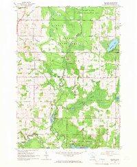 1965 Selkirk1966 Print · USGSIn the mid-1960s, this portion of Ogemaw County was a mix of protected state forests and active rural communities centered on the Rifle River. Researchers can trace the locations of many local institutions, including Selkirk, Churchill Sch, and several Aboriginal Earthworks.2 unique versions available
 - 1968 Map of Prescott, 1971 Print
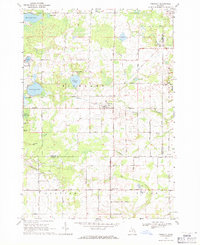 1968 Prescott1971 Print · USGSNorthern Michigan in the late sixties reveals a landscape of rural villages and energy extraction. Trace local family history at Richland Cem or follow the Old Railroad Grade past Prescott and the Oil Wells near Maple Ridge.
 - 1968 Map of Sage Lake, 1971 Print
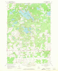 1968 Sage Lake1971 Print · USGSThe Ogemaw and Iosco county line area comes to life in the late 1960s, showing a landscape defined by the expansive Sage Lake and the Ogemaw State Forest. Genealogists and local historians can trace family locations near Logan Corners, Logan Cemetery, and the Church of the Nazarene.
 - 1968 Map of Skidway Lake, 1971 Print
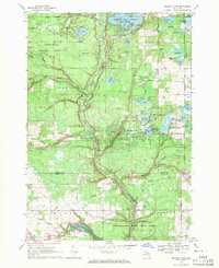 1968 Skidway Lake1971 Print · USGSIn the late sixties, the Ogemaw County lakes region was a burgeoning center for recreation and industry. Researchers can trace the Old Railroad Grade near Alger, locate the Clayton Oil and Gas Field, and find local landmarks like St Stephens Ch.
End of results
Showing maps 1-4 of 4
Top cities near Logan Township
- Skidway Lake historical maps
- Rose City historical maps
- Goodar historical maps
- Whittemore historical maps
- Prescott historical maps
- Twining historical maps
See more
Frequently asked questions
- What are the different types of historical maps available for Logan Township?
- What is the oldest map of Logan Township?
- Where can I purchase historical maps of Logan Township for my home or office?
- Where can I download high-res historical maps of Logan Township?
- Are there historical topographic maps available for Logan Township?
- Is there historical aerial imagery available for Logan Township?
- Where are historical maps of Logan Township sourced from?