1930s Maps of Ottawa County, Michigan
Explore 5 historic maps of Ottawa County from the 1930s. These maps offer a rare glimpse into what life looked like during the 1930s — showing old roads, neighborhoods, homes, and landmarks that have changed or disappeared over time.
Whether you're researching your family's past, planning a metal detecting trip, or studying how Ottawa County's landscape evolved across the 1930s, these high-resolution maps are a powerful tool for exploring the history of this region.
- Focus on a specific era: All maps on this page are from the 1930s, giving you a focused view of this time period.
- See what’s changed: Compare century-old streets, trails, and buildings to today's modern landscape using overlays and satellite layers.
- Research with precision: Use these maps for genealogy, historical research, land use analysis, or educational projects.
- View, download, or print: Maps are fully viewable online in high resolution, and can be downloaded or printed for your own records.
Start exploring Ottawa County's history through authentic maps from the 1930s. This is your window into the past.
Ottawa County, MI maps
(5)- 1930 Map of Lake Harbor
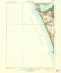
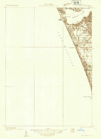 1930 Lake Harbor1930 Print · USGSThe industrial and recreational shoreline of Lake Michigan comes alive in this pre-war survey of the Muskegon region. Genealogists can trace family roots through specific locations like Indian Village, Port Sherman, and the Maple Grove Sch.
 - 1930 Map of Muskegon, 1960 Print
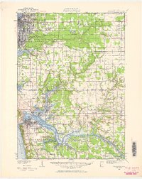 1930 Muskegon1960 Print · USGSThe Lake Michigan shoreline and the winding Grand River valley appear here as they were in the late 1920s. Researchers can locate dozens of country schools like Carr Sch and Jones Sch, or trace the tracks of the Pere Marquette railroad.2 unique versions available
 - 1932 Map of Holland
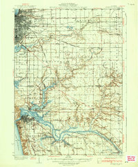
 1932 Holland1932 Print · USGSThe Lake Michigan shoreline and the growing city of Holland are captured here in the early 1930s. Trace the lakefront resorts and rural schoolhouses that once dotted the landscape, from Getz Lakewood Farm to the Harderwyk Sch and Noordeloos.2 unique versions available
 - 1936 Map of Muskegon
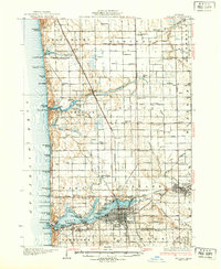
 1936 Muskegon1936 Print · USGSCoastal Muskegon and Ottawa counties thrive in the mid-1930s as vital rail and shipping hubs. Genealogists and historians can trace numerous bayous along the Grand River and locate dozens of rural landmarks like Spoonville Chapel and Bates Sch.2 unique versions available
 - 1936 Map of Lake Harbor
 1936 Lake Harbor1936 Print · USGSCoastal Muskegon and its industrial neighbors are captured in the mid-1930s as the region transitioned into a major Lake Michigan port. Genealogists and historians can trace neighborhood growth through landmarks like Indian Village, Maple Grove Sch, and the rail lines of the P M RY.3 unique versions available
End of results
Showing maps 1-5 of 5
Top cities of Ottawa County
- Spring Lake Township historical maps
- Grand Haven historical maps
- Hudsonville historical maps
- Zeeland historical maps
- Coopersville historical maps
- Ferrysburg historical maps
Frequently asked questions
- What are the different types of historical maps available for Ottawa County?
- What is the oldest map of Ottawa County?
- Where can I purchase historical maps of Ottawa County for my home or office?
- Where can I download high-res historical maps of Ottawa County?
- Are there historical topographic maps available for Ottawa County?
- Is there historical aerial imagery available for Ottawa County?
- Where are historical maps of Ottawa County sourced from?