1970s Maps of Pulawski Township, Michigan
Explore 4 historic maps of Pulawski Township from the 1970s. These maps offer a rare glimpse into what life looked like during the 1970s — showing old roads, neighborhoods, homes, and landmarks that have changed or disappeared over time.
Whether you're researching your family's past, planning a metal detecting trip, or studying how Pulawski Township's landscape evolved across the 1970s, these high-resolution maps are a powerful tool for exploring the history of this region.
- Focus on a specific era: All maps on this page are from the 1970s, giving you a focused view of this time period.
- See what’s changed: Compare century-old streets, trails, and buildings to today's modern landscape using overlays and satellite layers.
- Research with precision: Use these maps for genealogy, historical research, land use analysis, or educational projects.
- View, download, or print: Maps are fully viewable online in high resolution, and can be downloaded or printed for your own records.
Start exploring Pulawski Township's history through authentic maps from the 1970s. This is your window into the past.
Pulawski Township, MI maps
(4)- 1971 Map of Rogers City, 1974 Print
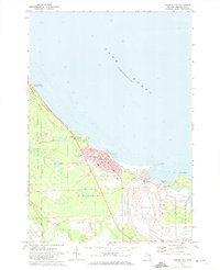 1971 Rogers City1974 Print · USGSPresque Isle County’s industrial and lakeside character comes to life in the early 1970s. Genealogists and researchers can trace the streets of Rogers City, locate parochial schools like St Johns Sch, and see the footprint of the massive Quarry.
 - 1971 Map of Metz, 1974 Print
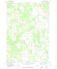 1971 Metz1974 Print · USGSMetz and the surrounding Presque Isle County countryside appear in the early 1970s as a landscape of timber, rail, and rural townships. Genealogists can locate family landmarks like Township Cem and St Johns Ch or trace the Detroit and Mackinac railroad line.
 - 1971 Map of Adams Point, 1974 Print
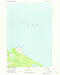 1971 Adams Point1974 Print · USGSThe Lake Huron coastline of northern Michigan comes into focus in the early 1970s, featuring the industrial and natural landscapes of Pulawski. Map collectors can trace the Detroit and Mackinac rail line and locate the massive Quarry at Adams Point.
 - 1971 Map of Posen, 1974 Print
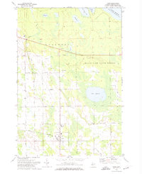 1971 Posen1974 Print · USGSPresque Isle County comes into focus in the 1970s, centered on the village of Posen and its rail connections. Genealogists and local historians can trace the foundations of the community through St Casimir Sch, the Cem, and rural routes like Leer Road.
End of results
Showing maps 1-4 of 4
Top cities near Pulawski Township
- Rogers City historical maps
- Presque Isle historical maps
- Belknap historical maps
- Metz historical maps
- Posen historical maps
Top neighborhoods of Pulawski Township
Frequently asked questions
- What are the different types of historical maps available for Pulawski Township?
- What is the oldest map of Pulawski Township?
- Where can I purchase historical maps of Pulawski Township for my home or office?
- Where can I download high-res historical maps of Pulawski Township?
- Are there historical topographic maps available for Pulawski Township?
- Is there historical aerial imagery available for Pulawski Township?
- Where are historical maps of Pulawski Township sourced from?