1960s Maps of Markey Township, Michigan
Explore 4 historic maps of Markey Township from the 1960s. These maps offer a rare glimpse into what life looked like during the 1960s — showing old roads, neighborhoods, homes, and landmarks that have changed or disappeared over time.
Whether you're researching your family's past, planning a metal detecting trip, or studying how Markey Township's landscape evolved across the 1960s, these high-resolution maps are a powerful tool for exploring the history of this region.
- Focus on a specific era: All maps on this page are from the 1960s, giving you a focused view of this time period.
- See what’s changed: Compare century-old streets, trails, and buildings to today's modern landscape using overlays and satellite layers.
- Research with precision: Use these maps for genealogy, historical research, land use analysis, or educational projects.
- View, download, or print: Maps are fully viewable online in high resolution, and can be downloaded or printed for your own records.
Start exploring Markey Township's history through authentic maps from the 1960s. This is your window into the past.
Markey Township, MI maps
(4)- 1963 Map of Roscommon South, 1964 Print
 1963 Roscommon South1964 Print · USGSRoscommon and the surrounding state forest are seen here in the early sixties as a center for transport and forestry. Trace local roots at the Township Cem, follow the New York Central tracks, or locate the Robinson Creek Dam and Bambi Lake.2 unique versions available
 - 1963 Map of Backus Lake, 1964 Print
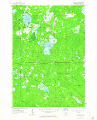 1963 Backus Lake1964 Print · USGSRoscommon County was a landscape of managed wetlands and state forests during the early 1960s. Outdoorsmen and local historians can trace the development of flooding areas like Backus Lake Flooding and find landmarks such as the Kingdom Hall and Ninemile Hill Swamp.3 unique versions available
 - 1963 Map of Prudenville, 1964 Print
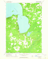
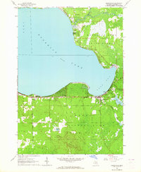 1963 Prudenville1964 Print · USGSPrudenville and the southeastern shores of Houghton Lake are captured here during the mid-1960s, showing a landscape of lakeside growth and forest preserves. Genealogists and researchers can locate family sites near Prudenville Cem, Lake James, and the North Shore Sch.2 unique versions available
 - 1963 Map of Lyon Manor, 1964 Print
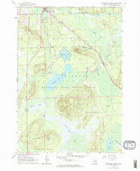
 1963 Lyon Manor1964 Print · USGSHiggins Lake and the surrounding Roscommon County woodlands are captured here in the early 1960s. Genealogists and local historians can trace the growth of Lyon Manor or locate historic landmarks like the Township Cem, Markey Ch, and Sharps Corners.3 unique versions available
End of results
Showing maps 1-4 of 4
Top cities near Markey Township
Top neighborhoods of Markey Township
Frequently asked questions
- What are the different types of historical maps available for Markey Township?
- What is the oldest map of Markey Township?
- Where can I purchase historical maps of Markey Township for my home or office?
- Where can I download high-res historical maps of Markey Township?
- Are there historical topographic maps available for Markey Township?
- Is there historical aerial imagery available for Markey Township?
- Where are historical maps of Markey Township sourced from?