
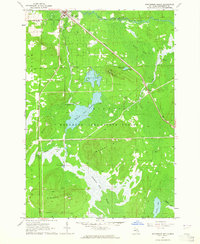
1963 Map of Roscommon South
USGS Topo · Published 1964About this map
The Roscommon village center and the surrounding woodlands of the Houghton Lake State Forest define this 1963 landscape. The northern portion of the map is anchored by the infrastructure of the New York Central railroad and the Roscommon Airfield, showing the area's development as a regional hub. Local landmarks include the Gerrish-Higgins Sch and the Township Cem, while an Experiment Station suggests the scientific management of the forest and agricultural land.
Find a feature on this map
30 named features on this map. Tap any name to fly to it.
Don’t see what you’re looking for? This feature index may not catch every label — zoom into the map to look around manually.
Map Details
Editions of this 1963 Roscommon South Map
2 editions found
Other maps of this area

1949 · Grayling
USGS Topo · 1:62,500

1950 · Roscommon North
USGS Topo · 1:24,000

1951 · Roscommon North
USGS Topo · 1:24,000

1951 · Pere Cheney
USGS Topo · 1:24,000

1954 · Traverse City
USGS Topo · 1:250,000

1958 · Traverse City
USGS Topo · 1:250,000

1963 · Backus Lake
USGS Topo · 1:24,000

1963 · Eldorado
USGS Topo · 1:24,000

1963 · Prudenville
USGS Topo · 1:24,000
1963 · Lyon Manor
USGS Topo · 1:24,000