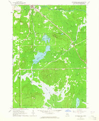
1963 Map of Roscommon South
USGS Topo · Published 1964About this map
Roscommon serves as the focal point for this mid-century survey, situated at the intersection of the New York Central railroad and regional roadways. The landscape is dominated by the extensive Houghton Lake State Forest, characterized by its complex network of wetlands and prominent elevations like Murray Hill and Ninemile Hill. Significant water management is evident at the Robinson Creek Dam, which created the large Robinson Creek Flooding area. Local infrastructure includes the Gerrish-Higgins Sch, the Township Cem, and the Roscommon Airfield. The map also captures the natural drainage of the region via the South Branch Au Sable River and Hudson Creek, which weave through Crossway Swamp and the Ninemile Swamp, illustrating the delicate balance between the area's timber resources and its hydraulic environment.
Find a feature on this map
34 named features on this map. Tap any name to fly to it.
Don’t see what you’re looking for? This feature index may not catch every label — zoom into the map to look around manually.
Map Details
Editions of this 1963 Roscommon South Map
2 editions found
Other maps of this area

1949 · Grayling
USGS Topo · 1:62,500

1950 · Roscommon North
USGS Topo · 1:24,000

1951 · Roscommon North
USGS Topo · 1:24,000

1951 · Pere Cheney
USGS Topo · 1:24,000

1954 · Traverse City
USGS Topo · 1:250,000

1958 · Traverse City
USGS Topo · 1:250,000

1963 · Roscommon South
USGS Topo · 1:24,000

1963 · Backus Lake
USGS Topo · 1:24,000

1963 · Eldorado
USGS Topo · 1:24,000

1963 · Prudenville
USGS Topo · 1:24,000