1970s Maps of Saginaw County, Michigan
Explore 9 historic maps of Saginaw County from the 1970s. These maps offer a rare glimpse into what life looked like during the 1970s — showing old roads, neighborhoods, homes, and landmarks that have changed or disappeared over time.
Whether you're researching your family's past, planning a metal detecting trip, or studying how Saginaw County's landscape evolved across the 1970s, these high-resolution maps are a powerful tool for exploring the history of this region.
- Focus on a specific era: All maps on this page are from the 1970s, giving you a focused view of this time period.
- See what’s changed: Compare century-old streets, trails, and buildings to today's modern landscape using overlays and satellite layers.
- Research with precision: Use these maps for genealogy, historical research, land use analysis, or educational projects.
- View, download, or print: Maps are fully viewable online in high resolution, and can be downloaded or printed for your own records.
Start exploring Saginaw County's history through authentic maps from the 1970s. This is your window into the past.
Saginaw County, MI maps
(9)- 1973 Map of Merrill, 1977 Print
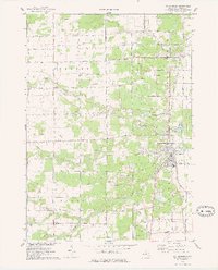
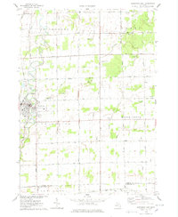
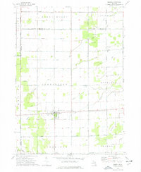 1973 Merrill1977 Print · USGSMerrill and its surrounding townships are shown in the early seventies as a thriving agricultural and industrial landscape. Genealogists and historians can trace family locations along O'Hara Road, locate the Merrill Ch, or find industrial sites like the Brine Well.
 - 1973 Map of Lakefield, 1977 Print
 1973 Lakefield1977 Print · USGSSaginaw County's rural townships are captured in the early seventies, showing a landscape defined by its river systems and agricultural grid. Genealogists and local historians can trace family roots near Lakefield and Galloway or locate the Sacred Heart Cem.
 - 1974 Map of Chapin, 1978 Print
 1974 Chapin1978 Print · USGSCentral Michigan farmland and managed game areas meet in the mid-1970s. Local researchers can locate family burial plots at St Theresa Cem, trace the rural community at Marion Springs, or find old school sites like Johns Sch.
 - 1974 Map of Chesaning West, 1978 Print
 1974 Chesaning West1978 Print · USGSSaginaw County farmland and river valleys are captured here in the mid-1970s. Trace local family history through old burial sites like Ridge Road Cem or explore the riverfront settlements of Oakley and Parshallburg (Havana).
 - 1975 Map of St. Charles, 1978 Print
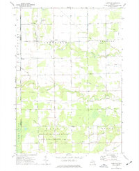
 1975 St. Charles1978 Print · USGSMid-1970s Saginaw County comes into focus as the Shiawassee River meets the Bad River at St Charles. Trace local family roots through country landmarks like Guardian Angels Ch and the Brant Cems, or follow the path of the CONRAIL line.
 - 1975 Map of Shields, 1978 Print
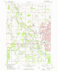 1975 Shields1978 Print · USGSSaginaw County’s western suburbs were expanding rapidly in the mid-seventies, balancing residential growth with large institutional and recreational spaces. Genealogists and historians can trace local landmarks like Oakwood Cem, the Apple Mountain Ski Area, and the Drive-in Theater.
 - 1975 Map of Alicia, 1978 Print
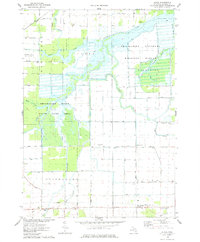 1975 Alicia1978 Print · USGSSaginaw County's river-rich lowlands are mapped here in the mid-1970s at the confluence of several major waterways. Researchers can trace the drainage and settlement patterns around Alicia, Prairie Farm, and the Shiawassee National Wildlife Refuge.
 - 1975 Map of Hemlock, 1978 Print
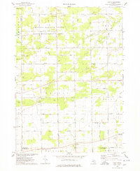
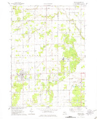 1975 Hemlock1978 Print · USGSSaginaw County's agricultural and industrial landscape is captured here in the mid-seventies, centered on the village of Hemlock. Genealogists and historians can trace numerous family-named roads, several Brine Wells, and local landmarks like St Johns Cem and the Sonefeld Landing Strip.
 - 1975 Map of Chesaning East, 1978 Print
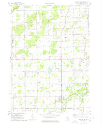
 1975 Chesaning East1978 Print · USGSSaginaw County's agricultural heartland is documented here in the mid-seventies, centered on the riverfront village of Chesaning. Genealogists and local historians can trace family locations near St Mary Cem, the Conrail line, and numerous rural crossroads like Amman Road.
End of results
Showing maps 1-9 of 9
Top cities of Saginaw County
Frequently asked questions
- What are the different types of historical maps available for Saginaw County?
- What is the oldest map of Saginaw County?
- Where can I purchase historical maps of Saginaw County for my home or office?
- Where can I download high-res historical maps of Saginaw County?
- Are there historical topographic maps available for Saginaw County?
- Is there historical aerial imagery available for Saginaw County?
- Where are historical maps of Saginaw County sourced from?