1910s Maps of Saginaw County, Michigan
Explore 7 historic maps of Saginaw County from the 1910s. These maps offer a rare glimpse into what life looked like during the 1910s — showing old roads, neighborhoods, homes, and landmarks that have changed or disappeared over time.
Whether you're researching your family's past, planning a metal detecting trip, or studying how Saginaw County's landscape evolved across the 1910s, these high-resolution maps are a powerful tool for exploring the history of this region.
- Focus on a specific era: All maps on this page are from the 1910s, giving you a focused view of this time period.
- See what’s changed: Compare century-old streets, trails, and buildings to today's modern landscape using overlays and satellite layers.
- Research with precision: Use these maps for genealogy, historical research, land use analysis, or educational projects.
- View, download, or print: Maps are fully viewable online in high resolution, and can be downloaded or printed for your own records.
Start exploring Saginaw County's history through authentic maps from the 1910s. This is your window into the past.
Saginaw County, MI maps
(7)- 1916 Map of Bay City
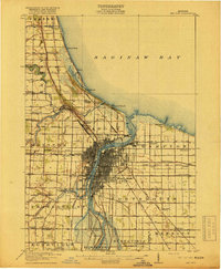 1916 Bay City1916 Print · USGSThe industrial waterfront of Saginaw Bay comes to life in this survey from the years preceding the Great Depression. Genealogists and historians can trace the early footprints of Bay City, locate rural schools like Sugar School, and follow the old Pere Marquette rail lines.
 - 1917 Map of Chesaning
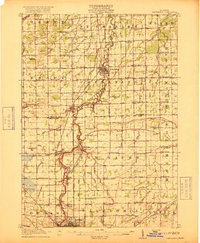 1917 Chesaning1917 Print · USGSSaginaw and Shiawassee Counties were thriving agricultural and rail hubs when this survey was completed in the mid-1910s. Genealogists and local historians can trace family roots through numerous country schoolhouses like Ziegler School and landmarks like the Sixmile Mine.4 unique versions available
 - 1917 Map of St. Charles
 1917 St. Charles1917 Print · USGSThe Saginaw Valley coal and rail corridor comes into focus here during the early twentieth century. Genealogists and researchers can trace family lands near dozens of local landmarks like No 3 Mine, Oakwood Cemetery, and the Prairie Farm.4 unique versions available
 - 1918 Map of Elsie
 1918 Elsie1918 Print · USGSCentral Michigan farmland and river valleys are captured here at the end of the Great War. Genealogists can trace family roots through numerous schoolhouses like Elba Center School and early rail stops at Carland, Bannister, and Munson Crossing.3 unique versions available
 - 1919 Map of Bay City
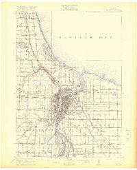 1919 Bay City1919 Print · USGSBay County at the height of its industrial and rail era shows a landscape defined by the Saginaw River and the bay. Local historians can trace the paths of the Hecla Belt Line and locate landmarks like Amelith, Sugar School, and Wenona Beach.2 unique versions available
 - 1919 Map of Saginaw
 1919 Saginaw1919 Print · USGSSaginaw and its river-based industrial corridor are captured here at a peak of rail and water transport just after the Great War. Genealogists and researchers can locate dozens of country schools like Jewett School, the Whatcheer Mine, and local stops such as Frankenmuth Junction.3 unique versions available
 - 1919 Map of Burt, 1959 Print
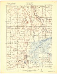
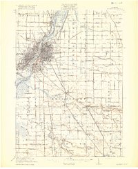
 1919 Burt1959 Print · USGSThe rural landscape between Saginaw and Flint is captured here in the years following the Great War. Genealogists can locate dozens of country schoolhouses like Marr School and Deneen School, or trace the path of the Michigan United Electric Railway.
End of results
Showing maps 1-7 of 7
Top cities of Saginaw County
Frequently asked questions
- What are the different types of historical maps available for Saginaw County?
- What is the oldest map of Saginaw County?
- Where can I purchase historical maps of Saginaw County for my home or office?
- Where can I download high-res historical maps of Saginaw County?
- Are there historical topographic maps available for Saginaw County?
- Is there historical aerial imagery available for Saginaw County?
- Where are historical maps of Saginaw County sourced from?