1960s Maps of Bridgeport Charter Township, Michigan
Explore 4 historic maps of Bridgeport Charter Township from the 1960s. These maps offer a rare glimpse into what life looked like during the 1960s — showing old roads, neighborhoods, homes, and landmarks that have changed or disappeared over time.
Whether you're researching your family's past, planning a metal detecting trip, or studying how Bridgeport Charter Township's landscape evolved across the 1960s, these high-resolution maps are a powerful tool for exploring the history of this region.
- Focus on a specific era: All maps on this page are from the 1960s, giving you a focused view of this time period.
- See what’s changed: Compare century-old streets, trails, and buildings to today's modern landscape using overlays and satellite layers.
- Research with precision: Use these maps for genealogy, historical research, land use analysis, or educational projects.
- View, download, or print: Maps are fully viewable online in high resolution, and can be downloaded or printed for your own records.
Start exploring Bridgeport Charter Township's history through authentic maps from the 1960s. This is your window into the past.
Bridgeport Charter Township, MI maps
(4)- 1967 Map of Birch Run North, 1968 Print
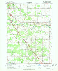 1967 Birch Run North1968 Print · USGSSaginaw County during the late sixties shows a landscape defined by the Cass River and the rise of the motor age. Genealogists can trace family names along Roedel Road while finding landmarks like St Lorenz Ch and the Dixie Highway Racetrack.2 unique versions available
 - 1967 Map of Saginaw NE, 1969 Print
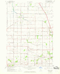 1967 Saginaw NE1969 Print · USGSThe Saginaw Valley in the late sixties shows a landscape defined by industrial growth and deep-rooted farming communities. Genealogists and researchers can trace local roots through landmarks like St Matthew Ch, the settlement of Frankentrost, and the Buena Vista Cem.2 unique versions available
 - 1967 Map of Bridgeport, 1969 Print
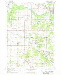 1967 Bridgeport1969 Print · USGSSaginaw County’s river-bound lowlands are captured here in the late sixties, showing the transition from rural farming to mid-century development. Researchers can trace family roots at Taymouth Cem or locate local landmarks like White Sch and the Radio Towers (WKNX).2 unique versions available
 - 1967 Map of Saginaw, 1969 Print
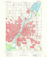 1967 Saginaw1969 Print · USGSSaginaw and its surrounding townships are shown here in the late sixties as a bustling hub of river commerce and rail transport. Researchers can locate dozens of neighborhood landmarks, from Forest Lawn Cemetery to the Grand Trunk Western RR yards.2 unique versions available
End of results
Showing maps 1-4 of 4
Top cities near Bridgeport Charter Township
- Saginaw historical maps
- Bay City historical maps
- City of Frankenmuth historical maps
- Frankenmuth historical maps
- Taymouth historical maps
- Kochville historical maps
See more
Top neighborhoods of Bridgeport Charter Township
Frequently asked questions
- What are the different types of historical maps available for Bridgeport Charter Township?
- What is the oldest map of Bridgeport Charter Township?
- Where can I purchase historical maps of Bridgeport Charter Township for my home or office?
- Where can I download high-res historical maps of Bridgeport Charter Township?
- Are there historical topographic maps available for Bridgeport Charter Township?
- Is there historical aerial imagery available for Bridgeport Charter Township?
- Where are historical maps of Bridgeport Charter Township sourced from?