1900s (20th Century) Maps of Grant Township, Michigan
Explore 7 historic maps of Grant Township from the 1900s (20th Century). These maps offer a rare glimpse into what life looked like during the 1900s — showing old roads, neighborhoods, homes, and landmarks that have changed or disappeared over time.
Whether you're researching your family's past, planning a metal detecting trip, or studying how Grant Township's landscape evolved across the 1900s, these high-resolution maps are a powerful tool for exploring the history of this region.
- Focus on a specific era: All maps on this page are from the 1900s, giving you a focused view of this time period.
- See what’s changed: Compare century-old streets, trails, and buildings to today's modern landscape using overlays and satellite layers.
- Research with precision: Use these maps for genealogy, historical research, land use analysis, or educational projects.
- View, download, or print: Maps are fully viewable online in high resolution, and can be downloaded or printed for your own records.
Start exploring Grant Township's history through authentic maps from the 1900s. This is your window into the past.
Grant Township, MI maps
(7)- 1954 Map of Flint, 1968 Print
 1954 Flint1968 Print · USGSThe industrial corridor and fertile Thumb region of Michigan come alive in this mid-century survey. Genealogists and historians can trace the rail networks of the Grand Trunk, locate established settlements like Bad Axe and Sandusky, or explore the 1950s shoreline along Saginaw Bay.4 unique versions available
 - 1958 Map of Flint
 1958 Flint1958 Print · USGSThe Michigan Thumb and the Saginaw Valley are captured here during the height of the post-war industrial era. Researchers can trace the complex rail networks of the Grand Trunk Western or locate mid-century landmarks like Lakeport State Park and the port at Bay City.2 unique versions available
 - 1961 Map of Ruby, 1963 Print
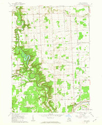 1961 Ruby1963 Print · USGSSt. Clair County in the early sixties shows a landscape of winding river valleys and rural rail corridors. Genealogists and historians can trace family locations near Ruby and Blaine, or locate old landmarks like Central Ch and the Kinney Cem.3 unique versions available
 - 1961 Map of Roseburg, 1963 Print
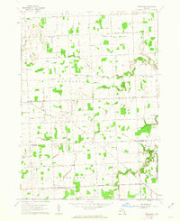 1961 Roseburg1963 Print · USGSSanilac and St. Clair counties are shown in the early sixties, featuring a landscape defined by traditional township grids and rural schoolhouses. Researchers can locate family landmarks like Fremont Cem, the Roseburg Sch, and the quiet crossroads of Livergood.2 unique versions available
 - 1961 Map of Avoca, 1963 Print
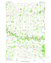 1961 Avoca1963 Print · USGSIn the early 1960s, this pocket of St. Clair County was a landscape of rail-fed hamlets and winding waterways. Researchers can trace the lineage of rural communities at Avoca, Fargo, and Abbottsford, alongside country landmarks like Emanuel Ch and Allen Sch.2 unique versions available
 - 1961 Map of Jeddo, 1963 Print
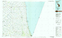
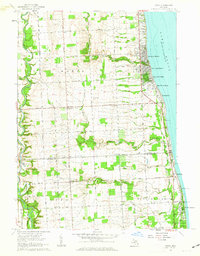 1961 Jeddo1963 Print · USGSThe Lake Huron shoreline and the rural interior of Sanilac and St. Clair counties are captured here in the early sixties. Genealogists and local historians can locate early schools and churches like Cook School and Bethel Church, or trace the Chesapeake and Ohio rail line.2 unique versions available
 - 1984 Map of Croswell, 1985 Print
 1984 Croswell1985 Print · USGSThe Michigan Thumb region and the Lake Huron shoreline appear here in the mid-1980s, showcasing a landscape of drainage-fed farmland and coastal retreats. Researchers can trace the Chesapeake rail route and explore shoreline communities from Lexington Heights to Keewahdin.2 unique versions available
End of results
Showing maps 1-7 of 7
Top cities near Grant Township
- Port Huron historical maps
- Marysville historical maps
- Kimball historical maps
- West Tappan historical maps
- Columbus Township historical maps
- Croswell historical maps
See more
Top neighborhoods of Grant Township
Frequently asked questions
- What are the different types of historical maps available for Grant Township?
- What is the oldest map of Grant Township?
- Where can I purchase historical maps of Grant Township for my home or office?
- Where can I download high-res historical maps of Grant Township?
- Are there historical topographic maps available for Grant Township?
- Is there historical aerial imagery available for Grant Township?
- Where are historical maps of Grant Township sourced from?