2020s Maps of Brown City, Michigan
Explore 2 historic maps of Brown City from the 2020s. These maps offer a rare glimpse into what life looked like during the 2020s — showing old roads, neighborhoods, homes, and landmarks that have changed or disappeared over time.
Whether you're researching your family's past, planning a metal detecting trip, or studying how Brown City's landscape evolved across the 2020s, these high-resolution maps are a powerful tool for exploring the history of this region.
- Focus on a specific era: All maps on this page are from the 2020s, giving you a focused view of this time period.
- See what’s changed: Compare century-old streets, trails, and buildings to today's modern landscape using overlays and satellite layers.
- Research with precision: Use these maps for genealogy, historical research, land use analysis, or educational projects.
- View, download, or print: Maps are fully viewable online in high resolution, and can be downloaded or printed for your own records.
Start exploring Brown City's history through authentic maps from the 2020s. This is your window into the past.
Brown City, MI maps
(2)- 2023 Map of Burnside, 2023 Print
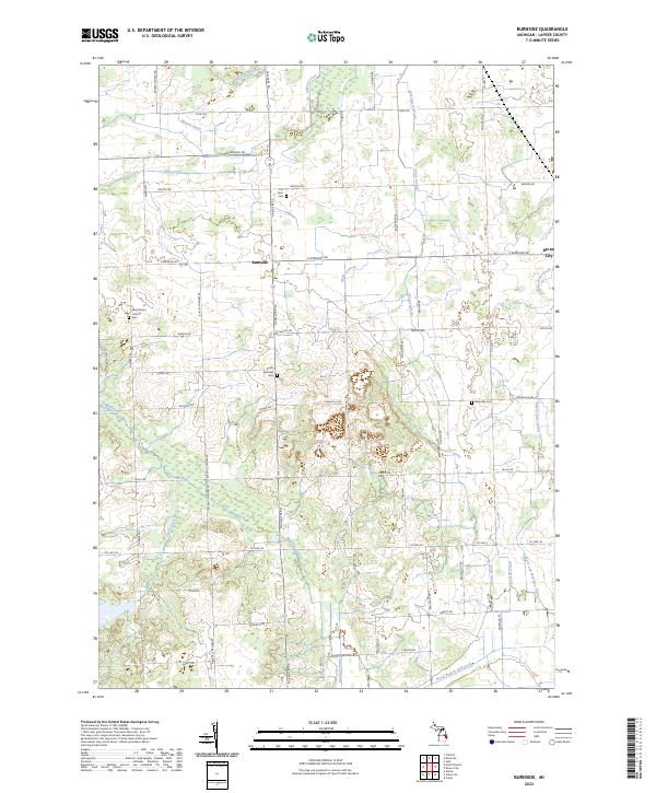 2023 Burnside2023 Print · USGSLapeer County's agricultural heartland is documented here in the early twenty-first century, showing the enduring rural layout around Burnside. Researchers can trace local lineage through several burial sites like Saint Mary's Catholic Cem and Deanville Cem.
 - 2023 Map of Brown City, 2023 Print
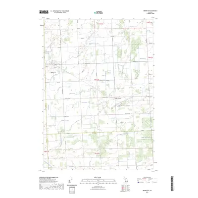 2023 Brown City2023 Print · USGSThe borderlands of Sanilac and St. Clair counties are shown here in the 2020s, dominated by a vast agricultural drainage network. Researchers can pinpoint Evergreen Cem, Valley Center Cem, and the small community of Valley Center.
End of results
Showing maps 1-2 of 2
Top cities near Brown City
- Attica historical maps
- Imlay City historical maps
- Sandusky historical maps
- Burnside historical maps
- Capac historical maps
- Brockway historical maps
See more
Frequently asked questions
- What are the different types of historical maps available for Brown City?
- What is the oldest map of Brown City?
- Where can I purchase historical maps of Brown City for my home or office?
- Where can I download high-res historical maps of Brown City?
- Are there historical topographic maps available for Brown City?
- Is there historical aerial imagery available for Brown City?
- Where are historical maps of Brown City sourced from?