1980s Maps of Keeler Township, Michigan
Explore 4 historic maps of Keeler Township from the 1980s. These maps offer a rare glimpse into what life looked like during the 1980s — showing old roads, neighborhoods, homes, and landmarks that have changed or disappeared over time.
Whether you're researching your family's past, planning a metal detecting trip, or studying how Keeler Township's landscape evolved across the 1980s, these high-resolution maps are a powerful tool for exploring the history of this region.
- Focus on a specific era: All maps on this page are from the 1980s, giving you a focused view of this time period.
- See what’s changed: Compare century-old streets, trails, and buildings to today's modern landscape using overlays and satellite layers.
- Research with precision: Use these maps for genealogy, historical research, land use analysis, or educational projects.
- View, download, or print: Maps are fully viewable online in high resolution, and can be downloaded or printed for your own records.
Start exploring Keeler Township's history through authentic maps from the 1980s. This is your window into the past.
Keeler Township, MI maps
(4)- 1981 Map of Twin Lakes, 1982 Print
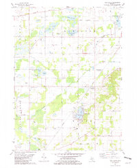 1981 Twin Lakes1982 Print · USGSSouthwestern Michigan’s lake country and the Dowagiac River valley are shown in detail during the early eighties. Researchers can locate family burial sites at North Wayne Cem and Gage Cem or trace the Amtrak line through Glenwood.
 - 1981 Map of Sister Lakes, 1982 Print
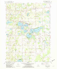 1981 Sister Lakes1982 Print · USGSThe lake country of Southwest Michigan is captured here in the early eighties, showcasing a dense network of resort communities and rural parish life. Genealogists and local historians can locate early burial sites like Keeler Cemetery, the historic Red Mill, and schools such as Indian Lake School.
 - 1981 Map of Hartford, 1982 Print
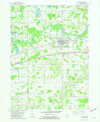 1981 Hartford1982 Print · USGSHartford and its surrounding rural townships are documented here in the early eighties as the rail and highway corridor thrived. Genealogists can locate family sites at Maple Hill Cem and Fairview Memorial Cem or trace community life at Woodside Sch and Stoughton Corners.
 - 1981 Map of Lawrence, 1982 Print
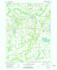 1981 Lawrence1982 Print · USGSThe village of Lawrence and its surrounding townships are shown here in the early eighties as a hub of river-and-rail activity. Genealogists can trace family sites at Hill Cem and Prospect Lake Cem, or locate the small community of Fritzburg.
End of results
Showing maps 1-4 of 4
Top cities near Keeler Township
- Dowagiac historical maps
- Covert historical maps
- Keeler historical maps
- Hartford historical maps
- Pokagon historical maps
- Sodus historical maps
See more
Top neighborhoods of Keeler Township
Frequently asked questions
- What are the different types of historical maps available for Keeler Township?
- What is the oldest map of Keeler Township?
- Where can I purchase historical maps of Keeler Township for my home or office?
- Where can I download high-res historical maps of Keeler Township?
- Are there historical topographic maps available for Keeler Township?
- Is there historical aerial imagery available for Keeler Township?
- Where are historical maps of Keeler Township sourced from?