1930s Maps of Van Buren Charter Township, Michigan
Explore 4 historic maps of Van Buren Charter Township from the 1930s. These maps offer a rare glimpse into what life looked like during the 1930s — showing old roads, neighborhoods, homes, and landmarks that have changed or disappeared over time.
Whether you're researching your family's past, planning a metal detecting trip, or studying how Van Buren Charter Township's landscape evolved across the 1930s, these high-resolution maps are a powerful tool for exploring the history of this region.
- Focus on a specific era: All maps on this page are from the 1930s, giving you a focused view of this time period.
- See what’s changed: Compare century-old streets, trails, and buildings to today's modern landscape using overlays and satellite layers.
- Research with precision: Use these maps for genealogy, historical research, land use analysis, or educational projects.
- View, download, or print: Maps are fully viewable online in high resolution, and can be downloaded or printed for your own records.
Start exploring Van Buren Charter Township's history through authentic maps from the 1930s. This is your window into the past.
Van Buren Charter Township, MI maps
(4)- 1936 Map of Wayne
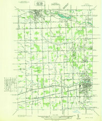 1936 Wayne1936 Print · USGSWestern Wayne County is seen here during the mid-1930s, showing the early suburban development between Plymouth and Wayne. Researchers can trace old property contexts and local landmarks like the Triangle Airport, Cadillac Mem Park Cem, and numerous country schools including Washington Sch.
 - 1936 Map of Belleville
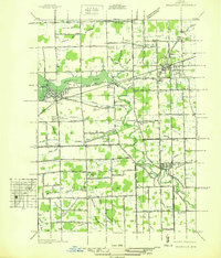 1936 Belleville1936 Print · USGSWestern Wayne County is seen here in the mid-1930s, showing a landscape defined by the Huron River and a burgeoning network of roads and rail. Researchers can locate old family plots and rural institutions like Martinsville Cem, Mt Pleasant Sch, and the Tyler Rd Community Hall.
 - 1936 Map of Denton
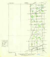 1936 Denton1936 Print · USGSThe borderlands of Washtenaw and Wayne counties come into focus during the mid-1930s, showing a landscape of small schools and intricate creek systems. Genealogists can locate family landmarks like Kinyon Cem and trace the paths of the Michigan Central Railroad through Denton.
 - 1936 Map of Ypsilanti East
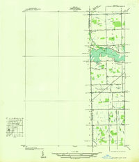 1936 Ypsilanti East1936 Print · USGSThe Washtenaw and Wayne County line in the mid-1930s is defined by the winding waters of Belleville Lake and a complex system of agricultural drains. Genealogists and local historians can locate early landmarks like Soop Cem, Willow Run Sch, and the settlement at Rawsonville.
End of results
Showing maps 1-4 of 4
Top cities near Van Buren Charter Township
- Detroit historical maps
- Ann Arbor historical maps
- Canton Charter Township historical maps
- Canton Township historical maps
- Livonia historical maps
- Dearborn historical maps
See more
Top neighborhoods of Van Buren Charter Township
- Denton historical maps
- Edgewater Heights historical maps
- Roulo historical maps
- Belleville North historical maps
- French Landing historical maps
Frequently asked questions
- What are the different types of historical maps available for Van Buren Charter Township?
- What is the oldest map of Van Buren Charter Township?
- Where can I purchase historical maps of Van Buren Charter Township for my home or office?
- Where can I download high-res historical maps of Van Buren Charter Township?
- Are there historical topographic maps available for Van Buren Charter Township?
- Is there historical aerial imagery available for Van Buren Charter Township?
- Where are historical maps of Van Buren Charter Township sourced from?