1980s Maps of Wexford County, Michigan
Explore 23 historic maps of Wexford County from the 1980s. These maps offer a rare glimpse into what life looked like during the 1980s — showing old roads, neighborhoods, homes, and landmarks that have changed or disappeared over time.
Whether you're researching your family's past, planning a metal detecting trip, or studying how Wexford County's landscape evolved across the 1980s, these high-resolution maps are a powerful tool for exploring the history of this region.
- Focus on a specific era: All maps on this page are from the 1980s, giving you a focused view of this time period.
- See what’s changed: Compare century-old streets, trails, and buildings to today's modern landscape using overlays and satellite layers.
- Research with precision: Use these maps for genealogy, historical research, land use analysis, or educational projects.
- View, download, or print: Maps are fully viewable online in high resolution, and can be downloaded or printed for your own records.
Start exploring Wexford County's history through authentic maps from the 1980s. This is your window into the past.
Wexford County, MI maps
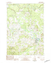
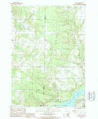
(23)- 1983 Map of Cadillac, 1984 Print
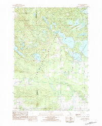
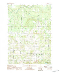
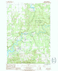
 1983 Cadillac1984 Print · USGSThe Cadillac region in the early eighties was defined by its vast public forests and the prominent dual lakes at its center. Trace the legacies of the timber era along the Old Railroad Grade or locate old rural centers like Vogel Center and Harrietta.
 - 1983 Map of Manton, 1984 Print
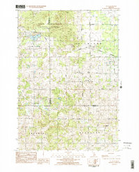
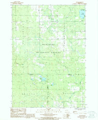
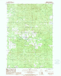
 1983 Manton1984 Print · USGSManton and its surrounding forests are captured here in the early 1980s, revealing a landscape defined by timberlands and small-town Michigan life. Researchers can locate family landmarks like Liberty Cem, trace the Michigan Northern rail line, or find old rural schoolhouses such as Carpenter Sch.
 - 1983 Map of Buckley, 1984 Print
 1983 Buckley1984 Print · USGSWexford and Grand Traverse counties meet in this early 1980s landscape of timber and small-town settlements. Genealogists and local historians can trace the rural layout of Buckley and Monroe Center, or locate family sites near St Marys Cem and the Red School.
 - 1983 Map of Cadillac North, 1984 Print
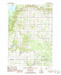
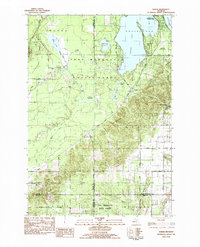
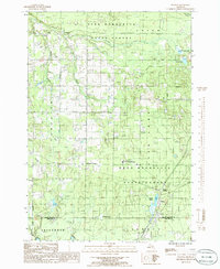
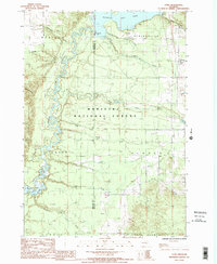
 1983 Cadillac North1984 Print · USGSWexford County in the early eighties shows the northward expansion of Cadillac between Lake Mitchell and the Pere Marquette State Forest. Trace the path of the Michigan Northern rail and find local landmarks like Missaukee Junction and the Fairground.
 - 1983 Map of Cadillac South, 1984 Print
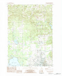
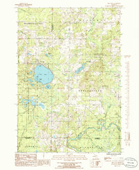
 1983 Cadillac South1984 Print · USGSCadillac and its southern lakefront are captured in the early 1980s as the city and forest lands meet. Genealogists can locate family names at Mt Carmel Cem and Hobart Cem or trace the early paths of the Northern railroad and Pine River.
 - 1983 Map of Traverse City, 1984 Print
 1983 Traverse City1984 Print · USGSTraverse City and the surrounding bay country are captured in the early eighties as the region balanced its timber heritage with growing conservation. Genealogists and local historians can trace the rail lines of the Ann Arbor RR through settlements like Kingsley and Fife Lake.2 unique versions available
 - 1983 Map of Jennings, 1984 Print
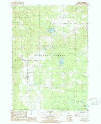
 1983 Jennings1984 Print · USGSJennings and the surrounding state forest are captured here in the early eighties, showcasing a region defined by its numerous lakes and timber heritage. Genealogists can locate both the Old Jennings Cem and New Jennings Cem, while history buffs can trace the path of the Lake City Railway.
 - 1983 Map of Lucas, 1984 Print
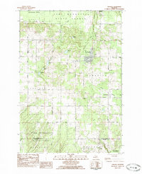
 1983 Lucas1984 Print · USGSMissaukee and Wexford counties are captured in the early eighties as a network of rural townships centered on the village of Lucas. Genealogists and local historians can trace family roots through sites like Richland Cem, the Lucas-McBain Sch, and the Michigan Northern railroad.2 unique versions available
 - 1983 Map of Karlin, 1984 Print
 1983 Karlin1984 Print · USGSNorthern Michigan’s forest and lake country is captured here during the early eighties, showcasing the intersection of four counties. You can trace family history at Karlin or locate rural landmarks like the De Lorme Cem, Grant Ch, and Pavlovic Corner.2 unique versions available
 - 1983 Map of Kingsley, 1984 Print
 1983 Kingsley1984 Print · USGSGrand Traverse County in the early eighties shows a landscape of rural townships and state forest land. Genealogists can locate family sites near Evergreen Cem, trace the Michigan Northern Railroad, or find the local Gleaner Hall.
 - 1983 Map of Arlene, 1984 Print
 1983 Arlene1984 Print · USGSMissaukee and Wexford counties are shown here in the early 1980s, where the state forest meets rural township life. Genealogists and local historians can locate Caldwell Ch, the Bloomfield Cemetery, and the riverfront Whip-Poor-Will Landing Strip.
 - 1985 Map of Walton, 1986 Print
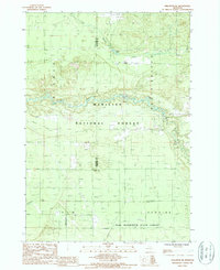
 1985 Walton1986 Print · USGSNorthern Michigan forest lands and river valleys are captured here in the mid-eighties. Researchers can trace the Old RR Grade and locate local landmarks like Mc Manus Corner and the Walton Junction settlement.
 - 1985 Map of Fife Lake, 1986 Print
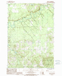
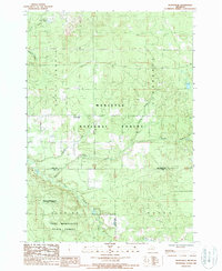
 1985 Fife Lake1986 Print · USGSThe Fife Lake region in the mid-1980s shows a landscape of glacial lakes and extensive timberlands managed by the Pere Marquette State Forest. Genealogists and local historians can trace the shoreline of Fife Lake, locate the community of Houseman, and follow the southern bend of the Manistee River.
 - 1987 Map of Axin, 1988 Print
 1987 Axin1988 Print · USGSWexford and Lake Counties are shown in the 1980s as a haven of managed timberland and lakefront recreation. Researchers can locate small communities like Mitchell and Axin, or trace the course of the North Branch Pine River through the Manistee National Forest.
 - 1987 Map of Mesick, 1988 Print
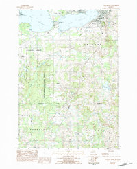
 1987 Mesick1988 Print · USGSWexford County's river valleys and state forests are captured here in the late eighties, just as the landscape of the Manistee River basin was being remapped. Genealogists and local historians can locate the streets of Mesick, the settlement at Sherman, and rural Cem locations.
 - 1987 Map of Mesick NE, 1988 Print
 1987 Mesick NE1988 Print · USGSWexford County in the mid-1980s is defined by its deep forests and the winding path of the Manistee River. Outdoorsmen and local historians can trace the creek networks and forest boundaries surrounding Grassy Lakes, Twin Lakes, and Ferguson Lake.
 - 1987 Map of Yuma, 1988 Print
 1987 Yuma1988 Print · USGSWexford and Manistee counties appear here in the mid-1980s, dominated by the winding river and the vast acreage of the Manistee National Forest. Local history researchers can trace old crossroads at Seaton and Yuma or locate the rural Cem and the historic Hodenpyl Dam.
 - 1987 Map of Harrietta, 1988 Print
 1987 Harrietta1988 Print · USGSHarrietta and the surrounding Manistee National Forest are captured here in the late eighties, showing a landscape defined by timber and cold-water streams. Researchers can locate the State Fish Hatchery and trace the paths of Slagle Creek and Perkins Creek.
 - 1987 Map of Harlan, 1988 Print
 1987 Harlan1988 Print · USGSThe border of Manistee and Wexford counties comes into focus in the late eighties as the region balanced forestry with recreational growth. Trace local history through the settlement at Harlan, the Cem, and the traces of an Old Railroad Grade.
 - 1987 Map of Wellston NE, 1988 Print
 1987 Wellston NE1988 Print · USGSThe northern Michigan forestlands of Wexford and Manistee counties are captured here in the late eighties, showing the convergence of two major state and national forests. Genealogists and historians can trace an Old Railroad Grade, a secluded Cem, and remote water bodies like Garlett Pond.
 - 1987 Map of Boon, 1988 Print
 1987 Boon1988 Print · USGSWexford County’s forest lands and glacial lakes are shown here in the late eighties, centered on the Manistee National Forest. Genealogists and local historians can trace the rural communities of Boon and Meauwataka and locate several country cemeteries.
 - 1987 Map of Hoxeyville, 1988 Print
 1987 Hoxeyville1988 Print · USGSWexford and Lake Counties in the late 1980s show a landscape shaped by vast state and national forests. Researchers can locate the settlement of Hoxeyville, trace the Pine River through Newkirk, and find local landmarks like the Cem and Ski Lifts.
 - 1989 Map of Traverse City, 1990 Print
 1989 Traverse City1990 Print · USGSNorthern Michigan’s lake-country and forest lands are captured in the late eighties as seasonal tourism and timber hubs expanded. Genealogists and historians can trace the routes of the Ann Arbor RR, the boundaries of Camp Grayling, and settlements like Elk Rapids and Manton.
End of results
Showing maps 1-23 of 23
Top cities of Wexford County
- Cadillac historical maps
- Haring Township historical maps
- Manton historical maps
- Harrietta historical maps
Frequently asked questions
- What are the different types of historical maps available for Wexford County?
- What is the oldest map of Wexford County?
- Where can I purchase historical maps of Wexford County for my home or office?
- Where can I download high-res historical maps of Wexford County?
- Are there historical topographic maps available for Wexford County?
- Is there historical aerial imagery available for Wexford County?
- Where are historical maps of Wexford County sourced from?